Country:
 Ukraine
Region:
City:
Latitude and Longitude:
Time Zone:
Postal Code:
IP information under different IP Channel
ip-api
Country
Region
City
ASN
Time Zone
ISP
Blacklist
Proxy
Latitude
Longitude
Postal
Route
IPinfo
Country
Region
City
ASN
Time Zone
ISP
Blacklist
Proxy
Latitude
Longitude
Postal
Route
MaxMind
Country
Region
City
ASN
Time Zone
ISP
Blacklist
Proxy
Latitude
Longitude
Postal
Route
Luminati
Country
UARegion
61
City
ternopil
ASN
Time Zone
Europe/Kyiv
ISP
Maxnet Telecom, Ltd
Latitude
Longitude
Postal
db-ip
Country
Region
City
ASN
Time Zone
ISP
Blacklist
Proxy
Latitude
Longitude
Postal
Route
ipdata
Country
Region
City
ASN
Time Zone
ISP
Blacklist
Proxy
Latitude
Longitude
Postal
Route
Popular places and events near this IP address
Tarnopol Voivodeship
Former voivodeship of Poland
Distance: Approx. 456 meters
Latitude and longitude: 49.550298,25.598627
Tarnopol Voivodeship (Polish: Województwo tarnopolskie; Ukrainian: Тернопільське воєводство, romanized: Ternopilske voievodstvo) was an administrative region of interwar Poland (1918–1939), created on 23 December 1920, with an area of 16,500 km2 and provincial capital in Tarnopol (now Ternopil, Ukraine). The voivodeship was divided into 17 districts (powiaty). At the end of World War II, at the insistence of Joseph Stalin during the Tehran Conference of 1943 without official Polish representation whatsoever, the borders of Poland were redrawn by the Allies.

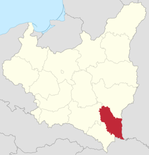
Ternopil Oblast
Region of Ukraine
Distance: Approx. 304 meters
Latitude and longitude: 49.55583333,25.5925
Ternopil Oblast (Ukrainian: Тернопільська область, romanized: Ternopiľśka oblasť), also referred to as Ternopilshchyna (Ukrainian: Тернопільщина, romanized: Ternopiľščyna) or Ternopillia (Ukrainian: Тернопілля, romanized: Ternopilľa), is an oblast (province) of Ukraine. Its administrative center is Ternopil, through which flows the Seret, a tributary of the Dniester. Population: 1,021,713 (2022 estimate).

Ternopil
City and administrative center of Ternopil Oblast, Ukraine
Distance: Approx. 1515 meters
Latitude and longitude: 49.56666667,25.6
Ternopil, known until 1944 mostly as Tarnopol, is a city in western Ukraine, located on the banks of the Seret. Administratively, it serves as the administrative centre of Ternopil Oblast. Ternopil is one of the major cities of Western Ukraine and the historical regions of Galicia and Podolia.
Roman Shukhevych Ternopil city stadium
Sports venue in Ternopil, Ukraine
Distance: Approx. 1046 meters
Latitude and longitude: 49.55305556,25.60916667
Roman Shukhevych Ternopil City Stadium (Ukrainian: Тернопільський міський стадіон імені Романа Шухевича) is a multi-use stadium in Ternopil, Ukraine. It is currently used mostly for football matches, and is the home of clubs FC Ternopil and FC Nyva Ternopil.
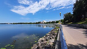
Ternopil Pond
Reservoir (Pond) in Ternopil, Ternopil Oblast
Distance: Approx. 1577 meters
Latitude and longitude: 49.56444444,25.58083333
Ternopil Lake (Ukrainian: Тернопільський став, known as Komsomol Lake before 1992, non-official Ternopil Lake) is a large artificial pond, a reservoir set in the center of Ternopil created in the place of swamps on the river Seret. Today Ternopil pond is surrounded by a park. It is a favorite walking place of residents and visitors of the city.

Ukrainian Catholic Archeparchy of Ternopil–Zboriv
Ukrainian Greek Catholic archeparchy in Ukraine
Distance: Approx. 1518 meters
Latitude and longitude: 49.5667,25.6
The Archeparchy of Ternopil - Zboriv is an ecclesiastical territory or ecclesiastical province of the Ukrainian Greek Catholic Church — a particular Eastern Catholic Church, that is located in Ukraine. It was erected in 1993. As a metropolitan see, it has two suffragan sees — Buchach and Kamyanets-Podilskyi.
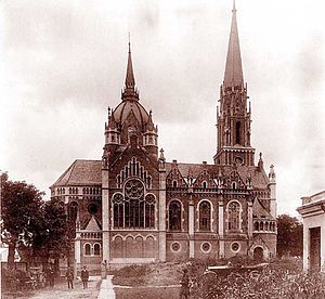
Church of St. Mary of the Perpetual Assistance, Ternopil
Destroyed Roman Catholic church in Ternopil, Ukraine
Distance: Approx. 22 meters
Latitude and longitude: 49.5533,25.5947
The Church of St. Mary of the Perpetual Assistance located in Tarnopol, Eastern Galicia (now Ternopil, Ukraine), was a church located in the city's centre which functioned as the parish church of Ternopil's Roman Catholic community. The church was built by the Latin Deacon of Ternopil and local rector, prelate Bolesław Twardowski, in the years 1903–1908, as a parish church for the city.

Ternopil National Medical University
Public medical university in the Ukraine
Distance: Approx. 362 meters
Latitude and longitude: 49.551667,25.590556
Ivan Horbachevsky Ternopil National Medical University or simply Ternopil National Medical University (Ukrainian: Тернопільський національний медичний університет імені І. Я. Горбачевського) is a government university run by the Ministry of Health as well as a medical university located in the city of Ternopil in Ukraine.
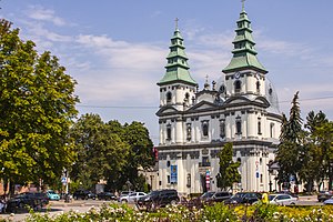
Cathedral of the Immaculate Conception of the Blessed Virgin Mary, Ternopil
Distance: Approx. 238 meters
Latitude and longitude: 49.553,25.5915
Cathedral of the Immaculate Conception of the Blessed Virgin Mary, formerly Dominican Church, is a Ukrainian Greek Catholic Cathedral in Ternopil, Ukraine overseen by the Ternopil–Zboriv Archdiocese. Built in the middle of the 18th century in a Late-Baroque-style, the cathedral is one of the defining sights of the city of Ternopil.

Church of the Exaltation of the Cross, Ternopil
Distance: Approx. 890 meters
Latitude and longitude: 49.551,25.583
Church of the Holy Cross (Vozdvizhenskaya, Zdvyzhenska, Nadstavna) is the oldest church in Ternopil in western Ukraine. It is an architectural monument of national importance which was built at the end of the 16th century. It is located on a hill overlooking Ternopil Pond and was built by Polish Crown Hetman Jan Tarnovsky on the site of an ancient wooden cathedral which dated back to Kyivan Rus times.
Ukrainian Catholic Eparchy of Zboriv
Former Ukrainian Catholic Eparchy in Ukraine (1993-2000)
Distance: Approx. 1518 meters
Latitude and longitude: 49.5667,25.6
The Eparchy of Zboriv was an eparchy of the Ukrainian Greek Catholic Church, in the ecclesiastical province of Lviv. It was established in 1993 and disestablished in 2000.
Ternopil urban hromada
Hromada in Ternopil Oblast, Ukraine
Distance: Approx. 1515 meters
Latitude and longitude: 49.56666667,25.6
Ternopil urban hromada (Ukrainian: Тернопільська міська громада, romanized: Ternopilska miska hromada) is a hromada of Ukraine, in Ternopil Raion of Ternopil Oblast. Its administrative center is Ternopil.
Weather in this IP's area
overcast clouds
14 Celsius
13 Celsius
14 Celsius
14 Celsius
1018 hPa
58 %
1018 hPa
980 hPa
10000 meters
3.46 m/s
7.64 m/s
91 degree
100 %
06:57:04
19:27:12