Country:
 Great Britain
Region:
City:
Latitude and Longitude:
Time Zone:
Postal Code:
IP information under different IP Channel
ip-api
Country
Region
City
ASN
Time Zone
ISP
Blacklist
Proxy
Latitude
Longitude
Postal
Route
IPinfo
Country
Region
City
ASN
Time Zone
ISP
Blacklist
Proxy
Latitude
Longitude
Postal
Route
MaxMind
Country
Region
City
ASN
Time Zone
ISP
Blacklist
Proxy
Latitude
Longitude
Postal
Route
Luminati
Country
 AE
AEASN
Time Zone
Asia/Dubai
ISP
INNETRA PC
Latitude
Longitude
Postal
db-ip
Country
Region
City
ASN
Time Zone
ISP
Blacklist
Proxy
Latitude
Longitude
Postal
Route
ipdata
Country
Region
City
ASN
Time Zone
ISP
Blacklist
Proxy
Latitude
Longitude
Postal
Route
Popular places and events near this IP address

Cardiff Queen Street railway station
Railway station in Cardiff, Wales
Distance: Approx. 185 meters
Latitude and longitude: 51.4819,-3.1703
Cardiff Queen Street railway station (Welsh: Caerdydd Heol y Frenhines) is a railway station serving the north and east of Central Cardiff, Wales. It is the fourth busiest railway station in Wales. It is located near the major thoroughfare of Queen Street and is one of 20 stations in the city.

Cardiff city centre
Central Business District in Wales
Distance: Approx. 270 meters
Latitude and longitude: 51.48,-3.17
Cardiff city centre (Welsh: Canol Dinas Caerdydd) is the city centre and central business district of Cardiff, Wales. The area is tightly bound by the River Taff to the west, the Civic Centre to the north and railway lines and two railway stations – Central and Queen Street – to the south and east respectively. Cardiff became a city in 1905.

Queens Arcade
Shopping mall in Cardiff, Wales
Distance: Approx. 290 meters
Latitude and longitude: 51.481,-3.177
The Queens Arcade (Welsh: Arcêd y Frenhines) is a shopping centre in Cardiff city centre. It opened on 28 April 1994.

St David's, Cardiff
Shopping centre in Cardiff, Wales
Distance: Approx. 201 meters
Latitude and longitude: 51.48083333,-3.17555556
St David's (Welsh: Dewi Sant), previously known as St David's Shopping Centre, is one of the principal shopping centres in the city centre of Cardiff, Wales. It is in The Hayes area of the southern city centre. Following the extension of St David's 2 in 2009, St David's is the third busiest shopping centre in the United Kingdom.

Capitol Centre, Cardiff
Shopping mall in Cardiff, Wales
Distance: Approx. 85 meters
Latitude and longitude: 51.48222222,-3.17222222
Capitol Centre (Welsh: Canolfan Capitol) (previously: Capitol Exchange Centre (Welsh: Canolfan cyfnewid Capitol)) is an indoor shopping centre in the city of Cardiff, Wales. Functioning as one of the city's retail malls, The building is built on the site of the former Capitol Theatre, and is situated at the eastern end of Queen Street near the Dumfries Place bus terminus and Cardiff Queen Street railway station. It was anchored by a large H&M store, with the front of the centre being dominated by Tesco since Virgin Megastores and Zavvi ceased operations in 2009.
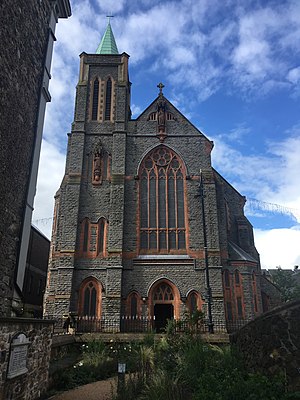
Cardiff Metropolitan Cathedral
Church in Cardiff, Wales
Distance: Approx. 108 meters
Latitude and longitude: 51.4809,-3.174
The Metropolitan Cathedral Church of St David (Welsh: Eglwys Gadeiriol Fetropolitan Dewi Sant), also known as St David's Cathedral, Cardiff, is a Catholic cathedral in the city centre of Cardiff, Wales, and is the centre of the Archdiocese of Cardiff. Located in Charles Street, the cathedral remains the focal point for Catholic life in Cardiff, and the country as a whole. It is one of only three Catholic cathedrals in the United Kingdom that is associated with a choir school.

Helmont House
Hotel and office building in Cardiff, Wales
Distance: Approx. 150 meters
Latitude and longitude: 51.481,-3.171
Helmont House is a high-rise hotel and office building in Cardiff, Wales. Completed in 1984, the 58-metre-high (190 ft) building has 12 floors and is the 15th-tallest building in Cardiff. The building was renovated in 2009 into a 200-room Premier Inn hotel.

Castle Quarter (Cardiff)
Area of Cardiff, Wales
Distance: Approx. 229 meters
Latitude and longitude: 51.48,-3.175
Castle Quarter (Welsh: Cwr y Castell) is an independent retail destination area in the north of the city centre of Cardiff, Wales. Castle is also a community (parish) of Cardiff. The listed Castle Quarter includes some of Cardiff's Victorian and Edwardian arcades: Castle Arcade, High Street Arcade and Duke Street Arcade, and principal shopping streets: St Mary Street, High Street, Castle Street and Duke Street.
Capitol Theatre, Cardiff
Former venue in Cardiff, Wales
Distance: Approx. 126 meters
Latitude and longitude: 51.4827,-3.1725
Capitol Theatre was a cinema and concert venue located in Cardiff, Wales, which featured a 3,158-seat auditorium was purpose built entertainment venue, which closed on 21 January 1978. It held an auditorium, a ballroom, three restaurants, a bar, a banqueting hall and a games hall.

City United Reformed Church
Church in Cardiff, Wales
Distance: Approx. 256 meters
Latitude and longitude: 51.4839,-3.1729
City United Reformed Church is a Grade II*-listed building located in Windsor Place, Cardiff. Originally constructed in 1866, it was listed in 1975. The church was designed in a Neogothic style by the Scottish architect Frederick Thomas Pilkington, and originally belonged to the Presbyterian denomination.
Guildford Crescent Baths
Former swimming building in Cardiff, UK
Distance: Approx. 257 meters
Latitude and longitude: 51.4798,-3.1706
The Guildford Crescent Baths, originally known as the Corporation Baths, was a public swimming pool building in the centre of Cardiff, Wales. It was demolished in 1985.

Bridge Street Exchange
High-rise building in Cardiff, Wales
Distance: Approx. 170 meters
Latitude and longitude: 51.4801,-3.1725
Bridge Street Exchange is a 26-storey high-rise building in Cardiff, Wales, with conjoining 11 and 5-storey blocks. At 85 m (279 ft) in height, it is the tallest building in Cardiff, and is a mixed-use development accommodating approximately 477 students with retail units on the ground floor. It is located on the eastern corner of the junction between Bridge Street and Charles Street.
Weather in this IP's area
overcast clouds
15 Celsius
15 Celsius
14 Celsius
16 Celsius
1022 hPa
84 %
1022 hPa
1021 hPa
10000 meters
4.12 m/s
50 degree
100 %
06:56:05
19:16:03