5.43.246.23 - IP Lookup: Free IP Address Lookup, Postal Code Lookup, IP Location Lookup, IP ASN, Public IP
Country:
Region:
City:
Location:
Time Zone:
Postal Code:
ISP:
ASN:
language:
User-Agent:
Proxy IP:
Blacklist:
IP information under different IP Channel
ip-api
Country
Region
City
ASN
Time Zone
ISP
Blacklist
Proxy
Latitude
Longitude
Postal
Route
db-ip
Country
Region
City
ASN
Time Zone
ISP
Blacklist
Proxy
Latitude
Longitude
Postal
Route
IPinfo
Country
Region
City
ASN
Time Zone
ISP
Blacklist
Proxy
Latitude
Longitude
Postal
Route
IP2Location
5.43.246.23Country
Region
komi, respublika
City
syktyvkar
Time Zone
Europe/Moscow
ISP
Language
User-Agent
Latitude
Longitude
Postal
ipdata
Country
Region
City
ASN
Time Zone
ISP
Blacklist
Proxy
Latitude
Longitude
Postal
Route
Popular places and events near this IP address
Syktyvkar
City in the Komi Republic, Russia
Distance: Approx. 1155 meters
Latitude and longitude: 61.66666667,50.81666667
Syktyvkar (, Russian: Сыктывка́р, IPA: [sɨktɨfˈkar]; Komi: Сыктывкар, IPA: [sɨktɨvˈkar]) is the capital city of the Komi Republic in Russia, as well as its largest city. It is also the administrative center of the Syktyvkar Urban Okrug. Until 1930, it was known as Ust-Sysolsk after the Sysola River.
Sysola
River in Russia
Distance: Approx. 2141 meters
Latitude and longitude: 61.6875,50.84222222
The Sysola (Russian: Сысола; Komi: Сыктыв, romanized: Syktyv) is located mainly in the Komi Republic in northwest Russia, although its two branches have their sources in Kirov Oblast and Perm Oblast. It is 487 kilometres (303 mi) long, and has a drainage basin of 17,200 square kilometres (6,600 sq mi). The Sysola is a tributary of the larger Vychegda, which it meets in Syktyvkar.
Syktyvkar Airport
Domestic airport in Syktyvkar, Komi Republic, Russia
Distance: Approx. 3187 meters
Latitude and longitude: 61.65722222,50.85388889
Syktyvkar Airport (IATA: SCW, ICAO: UUYY) is an airport in the Komi Republic, Russia located just within the city of Syktyvkar. It services medium-sized aircraft. The terminal is on the northwest side of the aerodrome with 10 large parking spaces and 9 small ones.

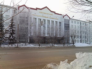
Syktyvkar State University
Building
Distance: Approx. 1466 meters
Latitude and longitude: 61.6645,50.821
Pitirim Sorokin Syktyvkar State University (Russian: Сыктывкарский государственный университет имени Питирима Сорокина; Komi: Сыктывкарса канму университет) is a public university in the city of Syktyvkar, the capital of the Komi Republic (Russia). With over 9,000 full-time students and more than 600 faculty members, it is the largest institution of higher education in the Komi Republic.
Syktyvdinsky District
District in Komi Republic, Russia
Distance: Approx. 7347 meters
Latitude and longitude: 61.61666667,50.75
Syktyvdinsky District (Russian: Сыктывдинский райо́н; Komi: Сыктывдін район, Syktyvdïn rajon) is an administrative district (raion), one of the twelve in the Komi Republic, Russia. It is located in the south of the republic. The area of the district is 7,405 square kilometers (2,859 sq mi).

Krasnozatonsky
Urban-type settlement in Komi Republic, Russia
Distance: Approx. 9234 meters
Latitude and longitude: 61.68333333,50.98333333
Krasnozatonsky (Russian: Краснозатонский; Komi: Гӧрд Затон, Görd Zaton) is an urban locality (an urban-type settlement) under the administrative jurisdiction of the city of republic significance of Syktyvkar in the Komi Republic, Russia. As of the 2010 Census, its population was 8,603.
Verkhnyaya Maksakovka
Urban-type settlement in Komi Republic, Russia
Distance: Approx. 9609 meters
Latitude and longitude: 61.63333333,50.96666667
Verkhnyaya Maksakovka (Russian: Верхняя Максаковка; Komi: Вылыс Максаковка, Vylys Maksakovka) is an urban locality (an urban-type settlement) under the administrative jurisdiction of the city of republic significance of Syktyvkar in the Komi Republic, Russia. As of the 2010 Census, its population was 4,198.

Vylgort, Syktyvdinsky District, Komi Republic
Rural locality in the Komi Republic, Russia
Distance: Approx. 5876 meters
Latitude and longitude: 61.6275,50.76722222
Vylgort (Russian: Выльгорт, Komi: Выльгорт, Vyľgort) is a rural locality (a selo) and the administrative center of Syktyvdinsky District of the Komi Republic, Russia. Population: 10,289 (2010 Census); 10,211 (2002 Census); 8,965 (1989 Soviet census).
Weather in this IP's area
overcast clouds
-5 Celsius
-10 Celsius
-5 Celsius
-5 Celsius
992 hPa
93 %
992 hPa
976 hPa
1665 meters
3.59 m/s
8.34 m/s
313 degree
100 %


