5.34.190.176 - IP Lookup: Free IP Address Lookup, Postal Code Lookup, IP Location Lookup, IP ASN, Public IP
Country:
Region:
City:
Location:
Time Zone:
Postal Code:
IP information under different IP Channel
ip-api
Country
Region
City
ASN
Time Zone
ISP
Blacklist
Proxy
Latitude
Longitude
Postal
Route
Luminati
Country
Region
25
City
brescia
ASN
Time Zone
Europe/Rome
ISP
Packet Loss s.r.l.
Latitude
Longitude
Postal
IPinfo
Country
Region
City
ASN
Time Zone
ISP
Blacklist
Proxy
Latitude
Longitude
Postal
Route
IP2Location
5.34.190.176Country
Region
lombardia
City
chiari
Time Zone
Europe/Rome
ISP
Language
User-Agent
Latitude
Longitude
Postal
db-ip
Country
Region
City
ASN
Time Zone
ISP
Blacklist
Proxy
Latitude
Longitude
Postal
Route
ipdata
Country
Region
City
ASN
Time Zone
ISP
Blacklist
Proxy
Latitude
Longitude
Postal
Route
Popular places and events near this IP address

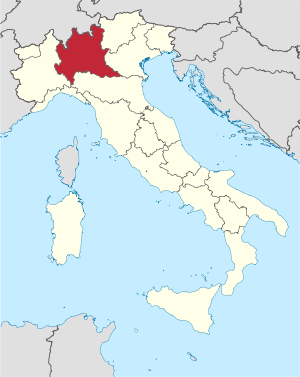
Lombardy
Region of Italy
Distance: Approx. 5388 meters
Latitude and longitude: 45.58333333,9.91666667
Lombardy (Italian: Lombardia; Lombard: Lombardia) is an administrative region of Italy that covers 23,844 km2 (9,206 sq mi); it is located in northern Italy and has a population of about 10 million people, constituting more than one-sixth of Italy's population. Lombardy is located between the Alps mountain range and tributaries of the river Po, and includes Milan, its capital, the largest metropolitan area in the country, and among the largest in the EU. Its territory is divided into 1,502 comuni (region with the largest number of comuni in the entire national territory), distributed in twelve administrative subdivisions (eleven provinces plus the Metropolitan City of Milan). The region ranks first in Italy in terms of population, population density, and number of local authorities, while it is fourth in terms of surface area, after Sicily, Piedmont, and Sardinia.
Castelcovati
Comune in Lombardy, Italy
Distance: Approx. 4279 meters
Latitude and longitude: 45.5,9.95
Castelcovati (Brescian: Castelcuàt) is a comune in the province of Brescia, in Lombardy.

Castrezzato
Comune in Lombardy, Italy
Distance: Approx. 4650 meters
Latitude and longitude: 45.51666667,9.98333333
Castrezzato (Brescian: Castrezàt) is a comune in the province of Brescia, in Lombardy, northern Italy. It is located in the plain between the rivers Oglio and Mella, The Autodromo di Franciacorta is nearby.

Chiari, Lombardy
Comune in Lombardy, Italy
Distance: Approx. 111 meters
Latitude and longitude: 45.53638889,9.92916667
Chiari (Lombard: Ciare) is a comune in the province of Brescia, in Lombardy, Italy. The 1701 Battle of Chiari was fought here during the War of the Spanish Succession. The town is the birthplace of Isidoro Chiari and Stefano Antonio Morcelli.
Coccaglio
Comune in Lombardy, Italy
Distance: Approx. 5363 meters
Latitude and longitude: 45.56666667,9.98333333
Coccaglio (Brescian: Cocài) is a town and comune in the province of Brescia, in Lombardy, Italy. It is approximately 32 kilometres (20 mi) west of Brescia and 35 kilometres (22 mi) southeast of Bergamo. The town is situated under the Monte Orfano, a lone hill in the midst of the Pianura Padana.

Cologne, Lombardy
Comune in Lombardy, Italy
Distance: Approx. 5285 meters
Latitude and longitude: 45.58333333,9.93333333
Cologne (Brescian: Culogne) is a town and commune in the province of Brescia, in Lombardy. Cologne is located in Franciacorta at the foot of Monte Orfano. Neighbouring communes are Coccaglio, Erbusco, Palazzolo sull'Oglio and Chiari.

Rovato
Comune in Lombardy, Italy
Distance: Approx. 5363 meters
Latitude and longitude: 45.56666667,9.98333333
Rovato (Brescian: Ruàt) is a comune in the province of Brescia, in Lombardy, northern Italy. Neighbouring towns are Coccaglio, Erbusco and Cazzago San Martino. It is located in the Franciacorta hills, 11 km south of Lake Iseo and 18 km west of Brescia.
Urago d'Oglio
Comune in Lombardy, Italy
Distance: Approx. 5412 meters
Latitude and longitude: 45.51666667,9.86666667
Urago d'Oglio (Brescian: Öràc d'Òi) is a comune in the province of Brescia, in Lombardy. It is situated on the left bank of the river Oglio, opposite the comune of Calcio. Its coat of arms shows on the left side a black half eagle on silver, and on the right side a half castle.

Battle of Chiari
1701 battle in Italy
Distance: Approx. 366 meters
Latitude and longitude: 45.53333333,9.93333333
The Battle of Chiari was fought on 1 September 1701 during the War of the Spanish Succession. The engagement was part of Prince Eugene of Savoy's campaign to seize the Spanish controlled Duchy of Milan in the Italian peninsula, and had followed his victory over Marshal Catinat at the Battle of Carpi in July. Marshal Villeroi replaced Catinat as commander of the Franco–Spanish–Savoyard forces in the theatre, carrying with him orders from King Louis XIV to push the Imperialists out of Italy.

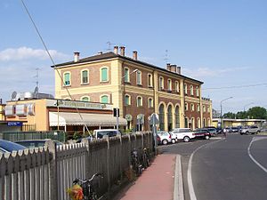
Chiari railway station
Railway station in Italy
Distance: Approx. 555 meters
Latitude and longitude: 45.53972222,9.92583333
Chiari (Italian: Stazione di Chiari) is a railway station serving the town of Chiari, in the region of Lombardy, northern Italy. The station opened in 1878 and is located on the Milan–Venice railway. The train services are operated by Trenord.

Rovato railway station
Railway station in Italy
Distance: Approx. 5805 meters
Latitude and longitude: 45.55222222,10.00111111
Rovato (Italian: Stazione di Rovato) is a railway station serving the town of Rovato, in the region of Lombardy, northern Italy. The station opened on 5 March 1878 and is located on the Milan–Venice railway and Bergamo–Brescia railway. The train services are operated by Trenord.

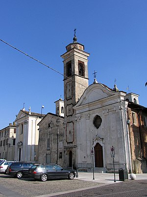
Santi Faustino e Giovita, Chiari
Distance: Approx. 95 meters
Latitude and longitude: 45.53642,9.92944
Santi Faustino e Giovita is the main Roman Catholic church or Duomo, and serves as cathedral for the town of Chiari, region of Lombardy, Italy. It is located on Piazza Zanardelli. Initially built in the 16th century, it underwent a number of reconstructions.
Weather in this IP's area
clear sky
-2 Celsius
-2 Celsius
-2 Celsius
-1 Celsius
1030 hPa
84 %
1030 hPa
1014 hPa
10000 meters
1.29 m/s
1.45 m/s
342 degree