Country:
Region:
City:
Latitude and Longitude:
Time Zone:
Postal Code:
IP information under different IP Channel
ip-api
Country
Region
City
ASN
Time Zone
ISP
Blacklist
Proxy
Latitude
Longitude
Postal
Route
Luminati
Country
ASN
Time Zone
Europe/Moscow
ISP
Gau No cit
Latitude
Longitude
Postal
IPinfo
Country
Region
City
ASN
Time Zone
ISP
Blacklist
Proxy
Latitude
Longitude
Postal
Route
db-ip
Country
Region
City
ASN
Time Zone
ISP
Blacklist
Proxy
Latitude
Longitude
Postal
Route
ipdata
Country
Region
City
ASN
Time Zone
ISP
Blacklist
Proxy
Latitude
Longitude
Postal
Route
Popular places and events near this IP address

Nizhny Novgorod
City in Nizhny Novgorod Oblast, Russia
Distance: Approx. 1559 meters
Latitude and longitude: 56.32694444,44.0075
Nizhny Novgorod ( NIZH-nee NOV-gə-rod; Russian: Нижний Новгород, IPA: [ˈnʲiʐnʲɪj ˈnovɡərət] , lit. 'Lower Newtown'; colloquially shortened to Nizhny) is the administrative centre of Nizhny Novgorod Oblast and the Volga Federal District in Russia. The city is located at the confluence of the Oka and the Volga rivers in Central Russia, with a population of over 1.2 million residents, up to roughly 1.7 million residents in the urban agglomeration.

Kuzma Minin
Russian military leader (1570s–1616)
Distance: Approx. 1534 meters
Latitude and longitude: 56.328309,44.001899
Kuzma Minin (Russian: Кузьма́ Ми́нин), full name Kuzma Minich Zakhariev-Sukhoruky (Russian: Кузьма́ Ми́нич Заха́рьев Сухору́кий; c. 1570s – May 21, 1616), was a Russian merchant who, together with Prince Dmitry Pozharsky, formed the popular uprising in Nizhny Novgorod against the Polish–Lithuanian Commonwealth's occupation of Russia during the Polish intervention in Russia (1605-1618) coinciding with the Time of Troubles. The popular uprising ultimately led to Russian victory at the Battle of Moscow and the end of Polish occupation in 1612. Minin and Pozharsky become national heroes in Russian culture and were honored in the Monument to Minin and Pozharsky in Moscow's Red Square.
Nizhny Novgorod Kremlin
Fortress in Nizhny Novgorod
Distance: Approx. 1569 meters
Latitude and longitude: 56.32850278,44.00256389
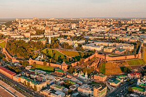
The Nizhny Novgorod Kremlin (Russian: Нижегородский кремль, romanized: Nizhegorodskiy kreml') is a fortress (kremlin) in the historic city center of Nizhny Novgorod, Russia.
Gorkovskaya (Nizhny Novgorod Metro)
Nizhny Novgorod Metro Station
Distance: Approx. 202 meters
Latitude and longitude: 56.31388889,43.995
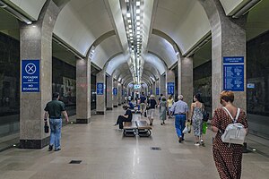
Gorkovskaya (Russian: Горьковская) is a station on the Nizhny Novgorod Metro and is the northern terminus on the Avtozavodskaya line. It opened on November 4, 2012. It is also the only station on the right bank of the Oka River in the historic Upper City section of Nizhny Novgorod.

Nizhny Novgorod Governorate
1714–1929 unit of Russia
Distance: Approx. 1555 meters
Latitude and longitude: 56.3269,44.0075
Nizhny Novgorod Governorate was an administrative-territorial unit (guberniya) of the Russian Empire, Russian Republic, and the Russian SFSR, roughly corresponding to the Upper and Middle Volga region and what is now most of the Nizhny Novgorod Oblast. In the early 20th Century, Nizhny Novgorod Governorate bordered Kostroma and Vyatka governorates to the north, Vladimir Governorate to the west, Kazan and Simbirsk governorates to the east, and Penza with Tambov governorates to the south. In the early 18th Century, Nizhny Novgorod Governorate was included in Kazan Governorate, from 1708–1714, and 1717–1719.

Bolshaya Pokrovskaya Street
Main street of Nizhny Novgorod
Distance: Approx. 885 meters
Latitude and longitude: 56.32222222,44.00055556
Bolshaya Pokrovskaya Street (Russian: Большая Покровская улица, lit. 'Greater Intercession Street'; short-name — Pokrovka, Russian: Покровка) is the high street in the historical centre of Nizhny Novgorod and one of its oldest streets. Until 1917 it was considered a street for noblemen. Formed the main street of the city by the end of the 18th century.

Rozhdestvenskaya Street
Street in Nizhny Novgorod, Russia
Distance: Approx. 1482 meters
Latitude and longitude: 56.32833333,43.9875
Rozhdestvenskaya Street (Russian: Рождественская улица, lit. 'Nativity Street') is a historic street in Nizhny Novgorod. Is a unique open-air museum, there are only stone houses, the history of the oldest of which dates back to the middle of the 18th century. Officially there are 35 monuments of architecture.

Stroganov Church
Church building in Nizhny Novgorod
Distance: Approx. 1339 meters
Latitude and longitude: 56.32688,43.98672
Church of the Nativity of the Blessed Virgin Mary (Russian: Церковь Собора Пресвятой Богородицы), better known as Nativity or Stroganov is a Russian Orthodox church, located at the Rozhdestvenskaya Street in Nizhny Novgorod. It was built in 1696–1719 on the means of the merchant Grigory Stroganov.
Nizhny Novgorod Synagogue
Synagogue in Nizhny Novgorod, Russia
Distance: Approx. 553 meters
Latitude and longitude: 56.32032017,43.99445836
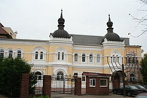
The Nizhny Novgorod Synagogue, also known as the Choral Synagogue in Nizhnii Novgorod, is a Jewish congregation and synagogue, located at 5 Gruzinskaia Street, in Nizhny Novgorod, in the Nizhny Novgorod Oblast of Russia. As of April 2018, the Jewish community of Nizhny Novgorod comprised more than 10,000 people. The synagogue was completed in 1884 in an eclectic style.

Boldino Museum
Historic site in Nizhny Novgorod Oblast, Russia
Distance: Approx. 1604 meters
Latitude and longitude: 56.32738528,44.0076365
Museum-reserve of Alexander Sergeevich Pushkin "Boldino" is a large Russian literary museum reserve, located in the complex of buildings of the family estate of Pushkin in the village of Bolshoye Boldino of the Nizhny Novgorod region, which is associated with one of the most fruitful periods of the poet's work, the "Boldino autumn" (September–November 1830).
Dmitrievskaya Tower
Building in Nizhny Novgorod, Russia
Distance: Approx. 1510 meters
Latitude and longitude: 56.327064,44.005697
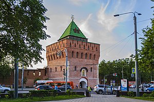
The Dmitrievskaya Tower (Russian: Дмитриевская башня, romanized: Dmitrievskaya bashnya) is the main tower on the southern wall of the Nizhny Novgorod Kremlin which overlooks the Minin and Pozharsky Square. The tower named after a powerful Prince of Suzdal and Nizhny Novgorod Dmitry of Suzdal. Another version claims that the name gave a church which was sanctified of the name of Saint Demetrius of Thessaloniki.
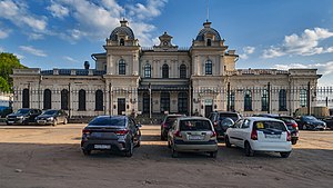
Romodanovsky railway station
Former station of the Nizhny Novgorod Moscow-Kazan railway
Distance: Approx. 1395 meters
Latitude and longitude: 56.3165,43.9707
Romodanovsky railway station (Kazansky railway station) is a former railway station in Nizhny Novgorod. Construction of this station started in 1900 and was completed in 1904. The station was functional until 1974.
Weather in this IP's area
broken clouds
4 Celsius
1 Celsius
4 Celsius
4 Celsius
1020 hPa
87 %
1020 hPa
999 hPa
10000 meters
4 m/s
310 degree
75 %
07:31:53
16:04:10