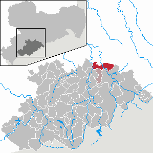
Country:
 Germany
Region:
City:
Latitude and Longitude:
Time Zone:
Postal Code:
IP information under different IP Channel
ip-api
Country
Region
City
ASN
Time Zone
ISP
Blacklist
Proxy
Latitude
Longitude
Postal
Route
IPinfo
Country
Region
City
ASN
Time Zone
ISP
Blacklist
Proxy
Latitude
Longitude
Postal
Route
MaxMind
Country
Region
City
ASN
Time Zone
ISP
Blacklist
Proxy
Latitude
Longitude
Postal
Route
Luminati
Country
DERegion
sn
City
reifland
ASN
Time Zone
Europe/Berlin
ISP
Tube-Hosting
Latitude
Longitude
Postal
db-ip
Country
Region
City
ASN
Time Zone
ISP
Blacklist
Proxy
Latitude
Longitude
Postal
Route
ipdata
Country
Region
City
ASN
Time Zone
ISP
Blacklist
Proxy
Latitude
Longitude
Postal
Route
Popular places and events near this IP address
Pockau
Ortsteil of Pockau-Lengefeld in Saxony, Germany
Distance: Approx. 3036 meters
Latitude and longitude: 50.7,13.21666667
Pockau is a village and a former municipality in the district of Erzgebirgskreis in Saxony, Germany. On 1 January 2014 it was merged with the town Lengefeld to form the town Pockau-Lengefeld. Pockau is on the Silver Road (Silberstraße).
Lengefeld
Ortsteil of Pockau-Lengefeld in Saxony, Germany
Distance: Approx. 1522 meters
Latitude and longitude: 50.71666667,13.18333333
Lengefeld is a town and a former municipality in the district Erzgebirgskreis, in the Free State of Saxony, Germany. It is situated in the Ore Mountains, 23 km southeast of Chemnitz. On 1 January 2014 it was merged with the municipality Pockau to form the town Pockau-Lengefeld.

Börnichen
Municipality in Saxony, Germany
Distance: Approx. 4945 meters
Latitude and longitude: 50.74944444,13.14138889
Börnichen is a municipality in the district Erzgebirgskreis, in Saxony, Germany.
Borstendorf
Ortsteil of Grünhainichen in Saxony, Germany
Distance: Approx. 5462 meters
Latitude and longitude: 50.77222222,13.17805556
Borstendorf is a village and a former municipality in the district Erzgebirgskreis, in Saxony, Germany. Since 1 January 2015 it is part of the municipality Grünhainichen.
Grünhainichen
Municipality in Saxony, Germany
Distance: Approx. 5728 meters
Latitude and longitude: 50.7675,13.15388889
Grünhainichen is a municipality in the district Erzgebirgskreis, in Saxony, Germany. On 1 March 2009, Grünhainichen and the neighboring municipality Waldkirchen were merged. On 1 January 2015, the former municipality Borstendorf became part of Grünhainichen.

Adlerstein
Distance: Approx. 3916 meters
Latitude and longitude: 50.69889,13.16333
The Adlerstein is a 676-metre-high summit in the Saxon Ore Mountains near Lengefeld. At the top there is a historic triangulation station which was part of the Royal Saxon triangulation network.

Lauterbacher Knochen
Distance: Approx. 4494 meters
Latitude and longitude: 50.690862,13.166682
The Lauterbacher Knochen is a 683-metre-high (2,241 ft) peak about one kilometre north of the village of Lauterbach in the municipality of Marienberg in the Ore Mountains. At the summit there is a historic station which was part of the Royal Saxon Triangulation Network.

Saidenbach Dam
Dam in Erzgebirgskreis
Distance: Approx. 2670 meters
Latitude and longitude: 50.73583,13.23417
The Saidenbach Dam (German: Talsperre Saidenbach) is a dam in the German state of Saxony. Its reservoir supplies drinking water to Chemnitz and, in conjunction with the Central Ore Mountain Dam System (Talsperrensystem Mittleres Erzgebirge) and its other dams - Neunzehnhain I und II and Einsiedel - contributes to the supply of the region covered by the South Saxony Long Distance Water Association (Zweckverbandes Fernwasser Südsachsen). To a lesser extent the dam is also used to generate electricity and for flood protection.

Rauenstein Castle
Castle in Pockau-Lengefeld, Erzgebirge, Saxony, Germany
Distance: Approx. 430 meters
Latitude and longitude: 50.72902778,13.20097222
Rauenstein Castle (German: Schloss Rauenstein) is a castle in the village of Rauenstein in the town of Pockau-Lengefeld in the Ore Mountains of Central Europe. The castle guarded the crossing over the River Flöha along the road from Freiberg to Annaberg.

Lengefeld Lime Works
German underground limestone quarry
Distance: Approx. 3462 meters
Latitude and longitude: 50.70035833,13.17065556
The Lengefeld Lime Works (German: Kalkwerk Lengefeld) was a limestone mine southwest of Lengefeld in the Saxon town of Pockau-Lengefeld in the Ore Mountains. In 2016, the mine was closed.

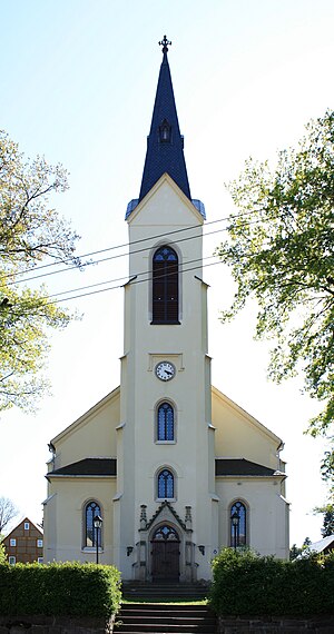
Pockau-Lengefeld
Place in town in Erzgebirgskreis, Saxony, Germany
Distance: Approx. 1522 meters
Latitude and longitude: 50.71666667,13.18333333
Pockau-Lengefeld is a town in the district Erzgebirgskreis, in Saxony, Germany. It is situated in the Ore Mountains, 23 km southeast of Chemnitz. It was formed by the merger of the municipality Pockau and the town Lengefeld on 1 January 2014.
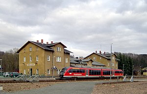
Pockau-Lengefeld station
Railway station in Pockau-Lengefeld, Germany
Distance: Approx. 2799 meters
Latitude and longitude: 50.7067,13.2271
Pockau–Lengefeld station is a local railway junction in Pockau-Lengefeld in the German state of Saxony. The Pockau-Lengefeld–Neuhausen railway branches off the Reitzenhain–Flöha railway here. The station and lines were opened in 1875.
Weather in this IP's area
overcast clouds
16 Celsius
15 Celsius
14 Celsius
16 Celsius
991 hPa
83 %
991 hPa
940 hPa
10000 meters
6.35 m/s
15.24 m/s
150 degree
100 %
07:22:07
18:25:48