5.226.149.179 - IP Lookup: Free IP Address Lookup, Postal Code Lookup, IP Location Lookup, IP ASN, Public IP
Country:
Region:
City:
Location:
Time Zone:
Postal Code:
IP information under different IP Channel
ip-api
Country
Region
City
ASN
Time Zone
ISP
Blacklist
Proxy
Latitude
Longitude
Postal
Route
Luminati
Country
Region
tg
City
frauenfeld
ASN
Time Zone
Europe/Zurich
ISP
Openfactory GmbH
Latitude
Longitude
Postal
IPinfo
Country
Region
City
ASN
Time Zone
ISP
Blacklist
Proxy
Latitude
Longitude
Postal
Route
IP2Location
5.226.149.179Country
Region
zurich
City
glattfelden
Time Zone
Europe/Zurich
ISP
Language
User-Agent
Latitude
Longitude
Postal
db-ip
Country
Region
City
ASN
Time Zone
ISP
Blacklist
Proxy
Latitude
Longitude
Postal
Route
ipdata
Country
Region
City
ASN
Time Zone
ISP
Blacklist
Proxy
Latitude
Longitude
Postal
Route
Popular places and events near this IP address
Töss (river)
River in Switzerland
Distance: Approx. 4001 meters
Latitude and longitude: 47.55211111,8.55405556
The Töss is a river in the Swiss canton of Zürich and a tributary of the High Rhine (Hochrhein). It starts at Tössscheidi, the confluence of the Vordertöss and Hindertöss (whose sources are in the canton of St. Gallen), passes through Winterthur's Töss and Wülflingen districts and ends at Tössegg near Freienstein-Teufen.
Stadel bei Niederglatt
Municipality in Zurich, Switzerland
Distance: Approx. 3861 meters
Latitude and longitude: 47.53333333,8.46666667
Stadel is a municipality in the district of Dielsdorf in the canton of Zürich in Switzerland.
Buchberg, Schaffhausen
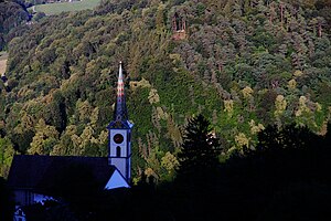
Municipality in Schaffhausen, Switzerland
Distance: Approx. 3735 meters
Latitude and longitude: 47.56666667,8.55
Buchberg is a municipality in the canton of Schaffhausen in Switzerland. With Rüdlingen, Buchberg forms one of the two exclaves of the Canton of Schaffhausen on the Rhine, bordered by the Canton of Zürich and Baden-Württemberg.

Eglisau
Municipality in Zürich, Switzerland
Distance: Approx. 2964 meters
Latitude and longitude: 47.58333333,8.51666667
Eglisau is a municipality in the district of Bülach in the canton of Zürich in Switzerland.

Glattfelden
Municipality in Zurich, Switzerland
Distance: Approx. 896 meters
Latitude and longitude: 47.56666667,8.5
Glattfelden is a municipality in the district of Bülach in the canton of Zürich in Switzerland, and belongs to the Glatt Valley (German: Glattal).
Wasterkingen
Municipality in Zurich, Switzerland
Distance: Approx. 3800 meters
Latitude and longitude: 47.58333333,8.46666667
Wasterkingen is a municipality in the district of Bülach in the canton of Zürich in Switzerland.
Glatt (Rhine)
River in Switzerland
Distance: Approx. 2873 meters
Latitude and longitude: 47.574,8.4709
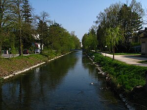
Glatt (German pronunciation: [ˈɡlat]) is the name of a lesser affluent to the High Rhine in the Unterland of the canton of Zurich, Switzerland. It is 35.7 kilometres (22.2 mi) long and flows out from the Greifensee through the Glatt Valley, discharging into the Rhine by Glattfelden. Whereas the upper reaches are only gently inclined, the stream gets steeper beneath, forming banks of bed load.
Zweidlen railway station
Railway station in Switzerland
Distance: Approx. 2854 meters
Latitude and longitude: 47.57038889,8.46788889
Zweidlen railway station (German: Bahnhof Zweidlen) is a railway station in the Swiss canton of Zürich and municipality of Glattfelden. It is located on the Winterthur to Koblenz line, and is served by Zürich S-Bahn line S36.

Glattfelden railway station
Railway station in Switzerland
Distance: Approx. 2024 meters
Latitude and longitude: 47.54861111,8.52411111
Glattfelden railway station (German: Bahnhof Glattfelden) is a railway station in the Swiss canton of Zurich. The station is actually situated in the municipality of Bülach but takes its name from the immediately adjacent municipality of Glattfelden. It is located on the Winterthur to Koblenz line of Swiss Federal Railways, and is served by Zurich S-Bahn line S9 between Zurich and Schaffhausen.
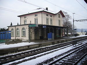
Eglisau railway station
Railway station in the canton of Zürich, Switzerland
Distance: Approx. 1891 meters
Latitude and longitude: 47.57238889,8.51661111
Eglisau railway station (German: Bahnhof Eglisau) is a railway station in the Swiss canton of Zurich and municipality of Eglisau. The station is located on the Winterthur to Koblenz line, at that line's junction with the Eglisau to Neuhausen line. Both lines are owned by Swiss Federal Railways.

Hüntwangen-Wil railway station
Railway station in Switzerland
Distance: Approx. 2630 meters
Latitude and longitude: 47.581114,8.512784
Hüntwangen-Wil is a railway station in the Swiss canton of Zurich. The station location straddles the municipalities of Eglisau and Hüntwangen, but takes its name from Hüntwangen and the adjoining municipality of Wil. In terms of railway geography, the station is on the Eglisau to Neuhausen line of the Swiss Federal Railway (SBB), which crosses the international border twice, travelling through German territory, on its route between the Swiss cantons of Zurich and Schaffhausen.

Eglisau railway bridge
Railway bridge in Eglisau, Switzerland
Distance: Approx. 2170 meters
Latitude and longitude: 47.57738,8.509941
The Eglisau railway bridge, or Eisenbahnbrücke Eglisau, is a single-track railway bridge which carries the Eglisau to Neuhausen line across the Rhine in Switzerland. Both ends of the bridge lie within the municipality of Eglisau and the canton of Zurich.
Weather in this IP's area
broken clouds
4 Celsius
0 Celsius
2 Celsius
4 Celsius
1026 hPa
86 %
1026 hPa
967 hPa
10000 meters
3.6 m/s
250 degree
75 %

