Country:
Region:
City:
Latitude and Longitude:
Time Zone:
Postal Code:
IP information under different IP Channel
ip-api
Country
Region
City
ASN
Time Zone
ISP
Blacklist
Proxy
Latitude
Longitude
Postal
Route
Luminati
Country
Region
14
City
minskmazowiecki
ASN
Time Zone
Europe/Warsaw
ISP
Ghelamco Poland Sp. z o.o.
Latitude
Longitude
Postal
IPinfo
Country
Region
City
ASN
Time Zone
ISP
Blacklist
Proxy
Latitude
Longitude
Postal
Route
db-ip
Country
Region
City
ASN
Time Zone
ISP
Blacklist
Proxy
Latitude
Longitude
Postal
Route
ipdata
Country
Region
City
ASN
Time Zone
ISP
Blacklist
Proxy
Latitude
Longitude
Postal
Route
Popular places and events near this IP address

Mińsk Mazowiecki
Place in Masovian Voivodeship, Poland
Distance: Approx. 306 meters
Latitude and longitude: 52.18333333,21.56666667
Mińsk Mazowiecki (Polish pronunciation: [ˈmij̃sk mazɔˈvjɛtskʲi] "Masovian Minsk") is a town in eastern Poland with 40,999 inhabitants (2020). It is situated in the Masovian Voivodeship and is a part of the Warsaw metropolitan area. It is the capital of Mińsk County.

Mińsk County
County in Masovian Voivodeship, Poland
Distance: Approx. 306 meters
Latitude and longitude: 52.18333333,21.56666667
Mińsk County (Polish: powiat miński) is a unit of territorial administration and local government (powiat) in Masovian Voivodeship, east-central Poland. It was (re)created on January 1, 1999, as a result of the Polish local government reforms passed in 1998. Its administrative seat and largest town is Mińsk Mazowiecki, which lies 39 kilometres (24 mi) east of Warsaw.

Gmina Mińsk Mazowiecki
Gmina in Masovian Voivodeship, Poland
Distance: Approx. 306 meters
Latitude and longitude: 52.18333333,21.56666667
Gmina Mińsk Mazowiecki is a rural gmina (administrative district) in Mińsk County, Masovian Voivodeship, in east-central Poland. Its seat is the town of Mińsk Mazowiecki, although the town is not part of the territory of the gmina. The gmina covers an area of 112.28 square kilometres (43.4 sq mi), and as of 2013, its total population is 14,628.
Gliniak
Village in Masovian Voivodeship, Poland
Distance: Approx. 2798 meters
Latitude and longitude: 52.15638889,21.55861111
Gliniak [ˈɡliɲak] is a village in the administrative district of Gmina Mińsk Mazowiecki, within Mińsk County, Masovian Voivodeship, in east-central Poland. It lies approximately 4 kilometres (2 mi) south of Mińsk Mazowiecki and 39 km (24 mi) east of Warsaw.

Huta Mińska
Village in Masovian Voivodeship, Poland
Distance: Approx. 2935 meters
Latitude and longitude: 52.15444444,21.56722222
Huta Mińska [ˈxuta ˈmiɲska] is a village in the administrative district of Gmina Mińsk Mazowiecki, within Mińsk County, Masovian Voivodeship, in east-central Poland.
Karolina, Mińsk County
Village in Masovian Voivodeship, Poland
Distance: Approx. 2368 meters
Latitude and longitude: 52.2,21.58333333
Karolina [karɔˈlina] is a village in the administrative district of Gmina Mińsk Mazowiecki, within Mińsk County, Masovian Voivodeship, in east-central Poland. It lies approximately 3 kilometres (2 mi) north-east of Mińsk Mazowiecki and 40 km (25 mi) east of Warsaw.
Karolina-Kolonia
Village in Masovian Voivodeship, Poland
Distance: Approx. 1527 meters
Latitude and longitude: 52.19333333,21.5775
Karolina-Kolonia [karɔˈlina kɔˈlɔɲa] is a village in the administrative district of Gmina Mińsk Mazowiecki, within Mińsk County, Masovian Voivodeship, in east-central Poland.

Stojadła
Village in Masovian Voivodeship, Poland
Distance: Approx. 2410 meters
Latitude and longitude: 52.18333333,21.53333333
Stojadła [stɔˈjadwa] is a village in the administrative district of Gmina Mińsk Mazowiecki, within Mińsk County, Masovian Voivodeship, in east-central Poland. It lies approximately 3 kilometres (2 mi) west of Mińsk Mazowiecki and 37 km (23 mi) east of Warsaw.
Targówka, Masovian Voivodeship
Village in Masovian Voivodeship, Poland
Distance: Approx. 2670 meters
Latitude and longitude: 52.16666667,21.6
Targówka [tarˈɡufka] is a village in the administrative district of Gmina Mińsk Mazowiecki, within Mińsk County, Masovian Voivodeship, in east-central Poland. It lies approximately 3 kilometres (2 mi) south-east of Mińsk Mazowiecki and 42 km (26 mi) east of Warsaw.

Wólka Mińska
Village in Masovian Voivodeship, Poland
Distance: Approx. 2540 meters
Latitude and longitude: 52.20361111,21.56777778
Wólka Mińska [ˈvulka ˈmiɲska] is a village in the administrative district of Gmina Mińsk Mazowiecki, within Mińsk County, Masovian Voivodeship, in east-central Poland.

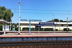
Mińsk Mazowiecki railway station
Railway station in Mińsk Mazowiecki, Poland
Distance: Approx. 1134 meters
Latitude and longitude: 52.17555556,21.55416667
Mińsk Mazowiecki railway station is a railway station serving Mińsk Mazowiecki in Masovian Voivodeship, Poland. It is served by Koleje Mazowieckie (who run services from Warszawa Zachodnia to Łuków) Polregio and PKP Intercity (TLK services). Some international trains also serve the station.
Mińsk Mazowiecki Ghetto
Nazi ghetto in occupied Poland
Distance: Approx. 309 meters
Latitude and longitude: 52.1792,21.5721
The Mińsk Mazowiecki Ghetto or the Mińsk Ghetto (Polish: Getto w Mińsku Mazowieckim, Yiddish: נאוואמינסק, Novominsk) was a World War II ghetto set up by Nazi Germany in occupied Poland. Some 7,000 Polish Jews were imprisoned there from all neighbouring settlements for the purpose of persecution and exploitation. Two years later, beginning 21 August 1942 during the most deadly phase of the Holocaust in occupied Poland, they were rounded up – men, women and children – and deported to Treblinka extermination camp aboard Holocaust trains.
Weather in this IP's area
light rain
5 Celsius
-0 Celsius
4 Celsius
6 Celsius
1004 hPa
96 %
1004 hPa
986 hPa
221 meters
7.76 m/s
13.68 m/s
236 degree
100 %
06:58:19
15:39:27
