Country:
 Great Britain
Region:
City:
Latitude and Longitude:
Time Zone:
Postal Code:
IP information under different IP Channel
ip-api
Country
Region
City
ASN
Time Zone
ISP
Blacklist
Proxy
Latitude
Longitude
Postal
Route
IPinfo
Country
Region
City
ASN
Time Zone
ISP
Blacklist
Proxy
Latitude
Longitude
Postal
Route
MaxMind
Country
Region
City
ASN
Time Zone
ISP
Blacklist
Proxy
Latitude
Longitude
Postal
Route
Luminati
Country
GBRegion
eng
City
barnet
ASN
Time Zone
Europe/London
ISP
Daisy Corporate Services Trading Ltd
Latitude
Longitude
Postal
db-ip
Country
Region
City
ASN
Time Zone
ISP
Blacklist
Proxy
Latitude
Longitude
Postal
Route
ipdata
Country
Region
City
ASN
Time Zone
ISP
Blacklist
Proxy
Latitude
Longitude
Postal
Route
Popular places and events near this IP address

Museum of London Docklands
Museum detailing the history of the River Thames and the London Docklands, in London, England
Distance: Approx. 116 meters
Latitude and longitude: 51.5075,-0.02361111
The London Museum Docklands (formerly known as Museum of London Docklands), based in West India Quay, explains the history of the River Thames, the growth of Port of London and the docks' historical link to the Atlantic slave trade. The museum is part of the Museum of London and is jointly funded by the City of London Corporation and the Greater London Authority. The museum opened in 2003 in grade I listed early-19th century Georgian "low" sugar warehouses built in 1802 on the north side of West India Docks, a short walk from Canary Wharf.
Columbus Tower (London)
Building in London, England
Distance: Approx. 49 meters
Latitude and longitude: 51.50715,-0.02459
Columbus Tower was a planned high-rise development by Commercial Estates Group approved for construction on a site on the Isle of Dogs, London Borough of Tower Hamlets. The 63-storey, 242 m (794 ft) AOD (Above Ordnance Datum) tower would have been located on a 0.36-hectare site at the western end of the north dock at West India Quay. At 2009 projected cost was £450M to build and reaching 237 metres in height, and projected was taller only by 2 m than One Canada Square.
West India Docks railway station
Former railway station in England
Distance: Approx. 162 meters
Latitude and longitude: 51.5086,-0.0242
West India Docks was a railway station in Limehouse, east London, that was opened by the Commercial Railway (later the London and Blackwall Railway) in 1840. It was situated between Limehouse and Millwall Junction stations, 2 miles 35 chains (3.9 km) down-line from Fenchurch Street. As the name implies, the station served the West India Docks, though it was located on the north side of the northernmost of the three docks; the LBR was later extended to a new Millwall Docks station to serve the other two docks.

West India Quay
Human settlement in England
Distance: Approx. 221 meters
Latitude and longitude: 51.50666667,-0.02222222
West India Quay is an area in the London Docklands, London, England. It is immediately to the north of the West India Docks and Canary Wharf. The warehouse at West India Quay was used to store imported goods from the West Indies, such as tea, sugar and rum, and is now a Grade I listed building.

1 Cabot Square
Commercial in London, England
Distance: Approx. 189 meters
Latitude and longitude: 51.50583333,-0.02388889
1 Cabot Square (also known as the Credit Suisse building) is a 21-floor office building in Cabot Square, Canary Wharf, London, England. From its completion in 1991 until 2023, the building's primary tenant was Credit Suisse.

15 Westferry Circus
Building in London, England
Distance: Approx. 242 meters
Latitude and longitude: 51.50513889,-0.02563889
15 Westferry Circus is a 16,250 m2 (174,900 sq ft) building located on the upper level of Westferry Circus, Canary Wharf. Construction began in November 1998. Its finish marked the completion of the Westferry Complex, the westernmost point of Canary Wharf.

11 Westferry Circus
Building
Distance: Approx. 145 meters
Latitude and longitude: 51.506,-0.0254
11 Westferry Circus is an office building located on the upper level of Westferry Circus, Canary Wharf development in London, United Kingdom. Reader's Digest owned and occupied the building until 1999, when the company sold the building and leased space in it from the new owner. The building was designed by a consortium of architectural firms.

Canary Riverside Plaza
Hotel in London, England
Distance: Approx. 239 meters
Latitude and longitude: 51.50609,-0.0281
Canary Riverside Plaza Hotel is a luxury 5-star hotel in London, England. It is located at 46 Westferry Circus in Canary Wharf. The hotel has 142 rooms and suites containing large bay windows overlooking the River Thames.
Charlie Brown's, Limehouse
Pub in London, England, c. 1840 to 1989
Distance: Approx. 171 meters
Latitude and longitude: 51.5088,-0.0247
Charlie Brown's was the common name for the Railway Tavern pub in Limehouse, London. The pub was built c. 1840 on the corner of Garford Street and the West India Dock Road and greatly extended in 1919. The pub was demolished in November 1989 during construction of the Limehouse Link tunnel.

Westferry Circus
Public space in Canary Wharf
Distance: Approx. 208 meters
Latitude and longitude: 51.505725,-0.02686944
Westferry Circus is a road interchange and public space within the Westferry Complex and is part of the Canary Wharf in London, and contains a two-level road interchange. There are two roundabouts, one above the other. It was designed by Laurie Olin.
Spire London
Construction Project
Distance: Approx. 49 meters
Latitude and longitude: 51.50715,-0.02459
Spire London, previously known as Hertsmere House, is a construction project located in West India Quay, near Canary Wharf. Developed by Greenland Group and designed by HOK, construction on the tallest building of 67 stories commenced in 2016, and (at that time) was targeted for completion in 2021. Upon completion, Spire London is due to become western Europe's tallest residential tower.
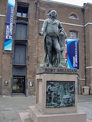
Statue of Robert Milligan
Sculpture by Richard Westmacott
Distance: Approx. 94 meters
Latitude and longitude: 51.50735,-0.02389
A statue of Robert Milligan was installed at the West India Docks in London, in 1813. Milligan was a merchant, and was largely responsible for the construction of the West India Docks. After being put in storage in 1943, it was re-erected by the London Docklands Development Corporation in 1997.
Weather in this IP's area
clear sky
25 Celsius
25 Celsius
23 Celsius
26 Celsius
1023 hPa
53 %
1023 hPa
1022 hPa
10000 meters
6.17 m/s
60 degree
9 %
06:41:53
19:05:48