Country:
 Great Britain
Region:
City:
Latitude and Longitude:
Time Zone:
Postal Code:
IP information under different IP Channel
ip-api
Country
Region
City
ASN
Time Zone
ISP
Blacklist
Proxy
Latitude
Longitude
Postal
Route
IPinfo
Country
Region
City
ASN
Time Zone
ISP
Blacklist
Proxy
Latitude
Longitude
Postal
Route
MaxMind
Country
Region
City
ASN
Time Zone
ISP
Blacklist
Proxy
Latitude
Longitude
Postal
Route
Luminati
Country
GBRegion
eng
City
barnet
ASN
Time Zone
Europe/London
ISP
Daisy Corporate Services Trading Ltd
Latitude
Longitude
Postal
db-ip
Country
Region
City
ASN
Time Zone
ISP
Blacklist
Proxy
Latitude
Longitude
Postal
Route
ipdata
Country
Region
City
ASN
Time Zone
ISP
Blacklist
Proxy
Latitude
Longitude
Postal
Route
Popular places and events near this IP address
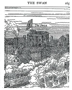
The Swan (theatre)
Former theatre in London, England
Distance: Approx. 82 meters
Latitude and longitude: 51.50694444,-0.10305556
The Swan was a theatre in Southwark, London, England, built in 1595 on top of a previously standing structure, during the first half of William Shakespeare's career. It was the fifth in the series of large public playhouses of London, after James Burbage's The Theatre (1576) and Curtain (1577), the Newington Butts Theatre (between 1575 and 1577) and Philip Henslowe's Rose (1587–88). The Swan Theatre was located in the manor of Paris Gardens, on the west end of the Bankside district of Southwark, across the Thames River from the City of London.

Blackfriars Road
Road in Southwark, London
Distance: Approx. 119 meters
Latitude and longitude: 51.50555556,-0.10444444
Blackfriars Road is a road in Southwark, SE1. It runs between St George's Circus at the southern end and Blackfriars Bridge over the River Thames at the northern end, leading to the City of London. Halfway up on the west side is Southwark Underground station, on the corner with The Cut.

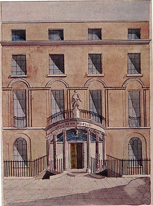
Surrey Institution
Distance: Approx. 153 meters
Latitude and longitude: 51.50791,-0.10476
The Surrey Institution was an organisation devoted to scientific, literary and musical education and research, based in London. It was founded by private subscription in 1807, taking the Royal Institution, founded in 1799, as a model. The Institution lasted only until 1823, when it was dissolved.
XXL (club)
London gay nightclub
Distance: Approx. 59 meters
Latitude and longitude: 51.5071,-0.1038
XXL was a gay nightclub in London and Birmingham which catered to the bear sub-group. The club was founded by Mark Ames and his then partner David Dindol in 2000. They separated in 2005, after which Mark purchased his ex-partner's share of the club.

Sampson House
Distance: Approx. 126 meters
Latitude and longitude: 51.5075,-0.103
Sampson House was a commercial office building in Hopton Street, Southwark, London, United Kingdom. It was sited just west of the Tate Modern art gallery, by the railway lines running onto Blackfriars Bridge and filled a block between the Thames and Southwark Street.
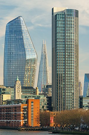
One Blackfriars
Building in London, England
Distance: Approx. 140 meters
Latitude and longitude: 51.5078,-0.1047
One Blackfriars is a mixed-use development at No. 1 Blackfriars Road in Bankside, London. It is informally known as The Vase or The Boomerang due to its shape.

Southwark Christchurch
Historic parish in London
Distance: Approx. 98 meters
Latitude and longitude: 51.50611111,-0.10527778
Christchurch was a civil parish in the metropolitan area of London, England. It was located south of the River Thames straddling either side of Blackfriars Road. It originated as the manor of Paris Garden in the parish of St Margaret, Southwark.

Christ Church, Southwark
Church in England
Distance: Approx. 76 meters
Latitude and longitude: 51.50626,-0.10505
Christ Church, Southwark, is a church of the Anglican denomination situated on the west side of Blackfriars Road, London. At the time of the foundation there was no bridge at Blackfriars and so no major road connecting the area to the south or to the City. The current church was built in 1958, following total destruction of the previous building in 1941, during the London Blitz.
Blackfriars Rotunda
Building in Southwark, London
Distance: Approx. 153 meters
Latitude and longitude: 51.50791,-0.10476
The Blackfriars Rotunda was a building in Southwark, near the southern end of Blackfriars Bridge across the River Thames in London, that existed from 1787 to 1958 in various forms. It initially housed the collection of the Leverian Museum after it had been disposed of by lottery. For a period it was home to the Surrey Institution.
Talkradio
Radio station
Distance: Approx. 186 meters
Latitude and longitude: 51.50611111,-0.10666667
TalkRadio (previously styled as talkRADIO) is a talk radio station broadcasting nationally in the United Kingdom, which was relaunched on 21 March 2016. Based in London and owned by Wireless Group, a subsidiary of News Corp., it is the sister station of national stations Talksport (itself originally known as Talk Radio UK), Talksport 2, Virgin Radio UK and Times Radio. Since the launch of its similarly named television station, TalkTV, in 2022 a large number of broadcasts are simulcast across both radio and television with the TalkTV branding being primarily used.

Hopton's Almshouses
Almshouses in London Borough of Southwark, UK
Distance: Approx. 179 meters
Latitude and longitude: 51.506698,-0.101527
Hopton's Almshouses are almshouses and a committee room in Southwark, London, SE1 at Hopton Gardens, 10–11 Hopton Street, all of which are Grade II* listed. They were built in 1746–49 by Thomas Ellis and William Cooley to the designs of the builder Mr Batterson, trustee of Charles Hopton's will. Originally built as 26 homes for poor men of Southwark of good character, in particular those from the Parish of Christchurch, Southwark, the buildings were extensively reconfigured in the 1980s and now comprise 20 single bedroom homes for older people from Southwark.

Poured Lines
2006 painting by Ian Davenport
Distance: Approx. 47 meters
Latitude and longitude: 51.50673611,-0.10345278
Poured Lines is a 2006 painting by the British painter Ian Davenport. It is the largest painting to be publicly displayed outdoors in the United Kingdom. It is situated under the rail bridge at the western end of Southwark Street in London SE1.
Weather in this IP's area
clear sky
25 Celsius
25 Celsius
23 Celsius
26 Celsius
1023 hPa
53 %
1023 hPa
1022 hPa
10000 meters
6.17 m/s
60 degree
7 %
06:42:12
19:06:07