Country:
 country.xk
Region:
City:
Latitude and Longitude:
Time Zone:
Postal Code:
IP information under different IP Channel
ip-api
Country
Region
City
ASN
Time Zone
ISP
Blacklist
Proxy
Latitude
Longitude
Postal
Route
IPinfo
Country
Region
City
ASN
Time Zone
ISP
Blacklist
Proxy
Latitude
Longitude
Postal
Route
MaxMind
Country
Region
City
ASN
Time Zone
ISP
Blacklist
Proxy
Latitude
Longitude
Postal
Route
Luminati
Country
XKCity
pristina
ASN
Time Zone
Europe/Belgrade
ISP
TelKos L.L.C
Latitude
Longitude
Postal
db-ip
Country
Region
City
ASN
Time Zone
ISP
Blacklist
Proxy
Latitude
Longitude
Postal
Route
ipdata
Country
Region
City
ASN
Time Zone
ISP
Blacklist
Proxy
Latitude
Longitude
Postal
Route
Popular places and events near this IP address
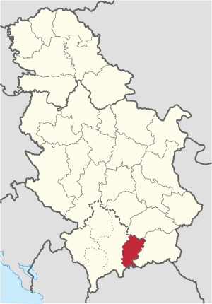
Kosovo-Pomoravlje District
District of Serbia on the territory of Kosovo
Distance: Approx. 6072 meters
Latitude and longitude: 42.5333,21.5667
The Kosovo-Pomoravlje District was a district of Kosovo and Metohija, part of the Republic of Serbia. The region is called Kosovo Pomoravlje. The area now has a population of 184,864.

Kamenica, Kosovo
Town and municipality in Gjilan, Kosovo
Distance: Approx. 427 meters
Latitude and longitude: 42.58388889,21.575
Kamenica or Dardana (Albanian definite form: Kamenicë or Dardanë), or Kosovska Kamenica (Serbian Cyrillic: Косовска Каменица), is a town and municipality located in the Gjilan District of Kosovo. According to the 2011 census, the town of Kamenica has 7,331 inhabitants, while the municipality has 36,085 inhabitants.
Përlepnicë Lake
Lake in Kosovo
Distance: Approx. 8449 meters
Latitude and longitude: 42.52638889,21.51277778
Përlepnicë Lake (Albanian: Liqeni i Përlepnicës; Serbian: Језеро Прилепница / Jezero Prilepnica) is a small lake in eastern Kosovo, surrounded by the Gollak mountains. A stream from the South Morava River flows through the lake, making it the largest lake in eastern Kosovo. The Përlepnicë Lake is just northeast of Gjilan city and provides water for the city.
Ruboc Lake
Lake in Kosovo
Distance: Approx. 3203 meters
Latitude and longitude: 42.5714,21.5414
Ruboc Lake (Albanian: Liqeni i Rubocit, Serbian: Језеро Robovac) is a very small lake in Kosovo. Robovac Lake is completely surrounded by the mountains of Gollak. It is the smallest lake in eastern Kosovo being about the same size as an average mountain lake.

Prilepnica
Village in Gjilan, Kosovo
Distance: Approx. 9453 meters
Latitude and longitude: 42.51278056,21.51916944
Prilepnica (Serbian Cyrillic: Прилепница) or Përlepnica (Albanian: Përlepnicë), is a village in the Kosovo Pomoravlje region of eastern Kosovo. The village is situated by the old mountainous road leading up to Novo Brdo, some 7 km from Gjilan.

Prilepac (fortress)
Serbian fortress
Distance: Approx. 6817 meters
Latitude and longitude: 42.54013889,21.52115556
Prilepac (Serbian Cyrillic: Прилепац), or Prilepnica (Serbian Cyrillic: Прилепница) was a Serbian medieval fortress near Kosovska Kamenica, Kosovo. It is most famous as the birthplace of Prince Lazar, who was born c. 1329.
Koretin
Village in Gjilan, Kosovo
Distance: Approx. 4606 meters
Latitude and longitude: 42.550019,21.597209
Koretin is a village in the Kamenicë municipality, eastern Kosovo.
Rogaçicë
Village in Gjilan, Kosovo
Distance: Approx. 9649 meters
Latitude and longitude: 42.55555556,21.68305556
Rogaçicë is a village in the Kamenicë municipality, eastern Kosovo.
Topanicë
Village in Gjilan, Kosovo
Distance: Approx. 7783 meters
Latitude and longitude: 42.52944444,21.62638889
Topanicë is a village in the Kamenicë municipality, eastern Kosovo.

Dardana Fortress
Archaeological site Kosovo
Distance: Approx. 1252 meters
Latitude and longitude: 42.59333333,21.56055556
The Dardana Fortress (Albanian: Kalaja e Dardanës) is an archaeological site of the Bronze Age, Iron Age and late antiquity in eastern Kosovo. It is located on a hill to the northwest of Kamenica. It was a hilltop settlement and fortress of the Dardani in classical antiquity.
Busavatë (site)
Archaeological site Kosovo
Distance: Approx. 2619 meters
Latitude and longitude: 42.58027778,21.54333333
Busavatë known locally as Guri i Madh and Kërshi i Madh is an archaeological site in Kosovo. The site is an ancient settlement which existed from the Late Bronze Age to late antiquity. The settlement began as a hilltop settlement on the Busavatë hill at an altitude of 725 m.

Ubožac Monastery
Orthodox Monastery
Distance: Approx. 2062 meters
Latitude and longitude: 42.5978,21.5947
Ubožac or Rđavac Monastery is a former Serbian Orthodox monastery, the ruins of which are located near the village of Močare, Serbia, not far from Kosovska Kamenica. The time of its creation is not known, and in scientific circles its rise is placed either in the middle of the 14th century or during the Ottoman rule. According to tradition, the founder is St.
Weather in this IP's area
overcast clouds
15 Celsius
15 Celsius
14 Celsius
15 Celsius
1018 hPa
94 %
1018 hPa
962 hPa
10000 meters
1.47 m/s
1.61 m/s
33 degree
100 %
06:19:06
18:35:07