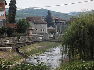
Country:
Region:
City:
Latitude and Longitude:
Time Zone:
Postal Code:
IP information under different IP Channel
ip-api
Country
Region
City
ASN
Time Zone
ISP
Blacklist
Proxy
Latitude
Longitude
Postal
Route
Luminati
Country
City
pristina
ASN
Time Zone
Europe/Belgrade
ISP
TelKos L.L.C
Latitude
Longitude
Postal
IPinfo
Country
Region
City
ASN
Time Zone
ISP
Blacklist
Proxy
Latitude
Longitude
Postal
Route
db-ip
Country
Region
City
ASN
Time Zone
ISP
Blacklist
Proxy
Latitude
Longitude
Postal
Route
ipdata
Country
Region
City
ASN
Time Zone
ISP
Blacklist
Proxy
Latitude
Longitude
Postal
Route
Popular places and events near this IP address
Viti, Kosovo
Town and municipality in Gjilan, Kosovo
Distance: Approx. 963 meters
Latitude and longitude: 42.31666667,21.35
Viti (Albanian definite form: Vitia) or Vitina (Serbian Cyrillic: Витина) is a town and municipality located in the District of Gjilan in Kosovo. According to the 2011 census, the town of Viti has 4,924 inhabitants, while the municipality has 46,987 inhabitants.
Pozharan
Village in Gjilan, Kosovo
Distance: Approx. 5070 meters
Latitude and longitude: 42.364808,21.337234
Požaranje (in Serbian; Пожарање), or Pozharan (in Albanian) is a town in the Viti, southeast Kosovo.
Kabash
Village in Gjilan, Kosovo
Distance: Approx. 2191 meters
Latitude and longitude: 42.302977,21.353306
Kabash is a town in the Viti Municipality of southeast Kosovo.
Binač
Village in Gjilan, Kosovo
Distance: Approx. 2716 meters
Latitude and longitude: 42.298045,21.363673
Binač (Serbian Cyrillic: Бинaч) or Binça (Albanian: Binçë), is a village in the municipality of Vitina in southeastern Kosovo. The Binač Monastery was destroyed in 1999, during the Kosovo unrests. It is in the Kosovo Pomoravlje region.

Klokot
Town and municipality in District of Gjilan, Kosovo
Distance: Approx. 5340 meters
Latitude and longitude: 42.36666667,21.38333333
Klokot (Serbian Cyrillic: Клокот) or Kllokot (Albanian definite form: Kllokoti) is a town and municipality in the District of Gjilan in southeastern Kosovo. The municipality was established on 8 January 2010, the settlements having been part of the municipality of Viti. The seat of the municipality is in the town of Klokot.
Kllokot-Vërban (archaeological site)
Archaeological site in Kosovo
Distance: Approx. 6730 meters
Latitude and longitude: 42.306149,21.280174
Part of a series of articles upon Archaeology of Kosovo Recorded traces of the Vërban archaeological site, inform us a lot about site selection for the settlement building during the Roman times. The site is set close to Klokot, in an alluvial terrace stretched along the Morava river flow, an area known for the fertile land and near the warm thermal mineral waters spring. One of the most interesting accidental archaeological discoveries is a sculpture found near the Banja e Kllokotit, a masterpiece of the Dardanian art, presenting an example of the distinguished autochthonous sculpturing art, of advanced artistic creation.
Grnčar, Klokot
Village in Gjilan, Kosovo
Distance: Approx. 4710 meters
Latitude and longitude: 42.326,21.416
Grnčar (Serbian Cyrillic: Грнчар, Albanian: Gërncar), formerly Grnčare (Грнчаре, until 1975), is a village in the Klokot municipality, in southeastern Kosovo. It was formerly part of the Vitina municipality, then was together with Klokot and Vrbovac formed as part the Klokot municipality on 8 January 2010, based on the Ahtisaari plan. The village, and municipality, is a Kosovo Serb enclave.
Beguncë
Village in Gjilan, Kosovo
Distance: Approx. 3353 meters
Latitude and longitude: 42.301398,21.388465
Beguncë (Albanian: Beguncë, Serbian Cyrillic: Бегунце/Begunce) is a village in Viti municipality, Kosovo.
Sllatinë e Epërme
Village in Gjilan, Kosovo
Distance: Approx. 6681 meters
Latitude and longitude: 42.359949,21.29588
Sllatinë e Epërme (Albanian: Sllatinë e Epërme, Serbian Cyrillic: Горња Слатина/Gornja Slatina) is a village in Viti municipality, Kosovo.
Smirë
Village in Gjilan, Kosovo
Distance: Approx. 4104 meters
Latitude and longitude: 42.298168,21.321202
Smirë (Albanian: Smirë, Serbian Cyrillic: Смира/Smira) is a village in Viti municipality, Kosovo.
Lubishtë
Village in Gjilan, Kosovo
Distance: Approx. 5310 meters
Latitude and longitude: 42.2947,21.4117
Lubishtë (Albanian: Lubishtë, Serbian: Љубиште) is a village in the municipality of Vitia, Kosovo.
Mogila, Kosovo
Village in Gjilan, Kosovo
Distance: Approx. 3481 meters
Latitude and longitude: 42.34108,21.39272
Mogila (Albanian: Mogillë, Serbian: Могила) is a village in the municipality of Klokot, Kosovo.
Weather in this IP's area
overcast clouds
1 Celsius
-1 Celsius
1 Celsius
2 Celsius
1026 hPa
57 %
1026 hPa
964 hPa
10000 meters
1.76 m/s
2.05 m/s
2 degree
100 %
06:19:21
16:17:47

