Country:
Region:
City:
Latitude and Longitude:
Time Zone:
Postal Code:
IP information under different IP Channel
ip-api
Country
Region
City
ASN
Time Zone
ISP
Blacklist
Proxy
Latitude
Longitude
Postal
Route
Luminati
Country
City
pristina
ASN
Time Zone
Europe/Belgrade
ISP
TelKos L.L.C
Latitude
Longitude
Postal
IPinfo
Country
Region
City
ASN
Time Zone
ISP
Blacklist
Proxy
Latitude
Longitude
Postal
Route
db-ip
Country
Region
City
ASN
Time Zone
ISP
Blacklist
Proxy
Latitude
Longitude
Postal
Route
ipdata
Country
Region
City
ASN
Time Zone
ISP
Blacklist
Proxy
Latitude
Longitude
Postal
Route
Popular places and events near this IP address
Lipjan
Town and municipality in District of Pristina, Kosovo
Distance: Approx. 1402 meters
Latitude and longitude: 42.53,21.13861111
Lipjan (Albanian definite form: Lipjani) or Lipljan (Serbian Cyrillic: Липљан) is a town and municipality located in the Pristina District of Kosovo. According to the 2011 census, the town of Lipjan has 6,870 inhabitants, while the municipality has 57,605 inhabitants.

Pristina International Airport
Airport in Pristina, Kosovo
Distance: Approx. 8824 meters
Latitude and longitude: 42.57277778,21.03583333
Prishtina International Airport Adem Jashari (Albanian: Aeroporti Ndërkombëtar i Prishtinës Adem Jashari), also referred to as Pristina International Airport (Albanian: Aeroporti Ndërkombëtar i Prishtinës, IATA: PRN, ICAO: BKPR), is an international airport in Pristina, Kosovo. The airport is located 15 km (9.3 mi) southwest of the city of Pristina, Kosovo. The airport has flights to numerous European destinations.

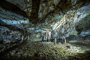
Marble Cave, Kosovo
Cave in Kosovo
Distance: Approx. 8507 meters
Latitude and longitude: 42.48006,21.205538
The Marble Cave or the Gadime Cave (Albanian: Shpella e Mermerit; Serbian: Мермерна пећина/Mermerna pećina) is a karstic limestone cave in the village of Gadime e Ulët in the municipality of Lipjan in Kosovo. Much of it is still unexplored. The cave was found in 1966 by a villager, Ahmet Asllani, who was working on his garden.

Ulpiana
Justiniana Secunda - ancient Roman city located in what is today Kosovo
Distance: Approx. 8950 meters
Latitude and longitude: 42.596281,21.175025
Ulpiana was an ancient Roman city located in what is today Kosovo. It was also named Justiniana Secunda (Latin: Iustiniana Secunda, Albanian: Justinianë Sekundë. Ulpiana is located in the municipality of Graçanicë, 12 km southeast of Prishtinë.
Llapllasella
Village in Kosovo
Distance: Approx. 8031 meters
Latitude and longitude: 42.59666667,21.14083333
Llapllasella (Serbian Cyrillic: Лапље Село, Albanian: Llapllaselle) is a village in the Graçanicë municipality of Kosovo. Llapllasella was part of the Pristina municipality before the Gračanica municipality was created. It is a Serb enclave situated south of Čaglavica, and has a supermajority of ethnic Serbs.

Incident at Pristina Airport
1999 confrontation between Russian and NATO forces
Distance: Approx. 8824 meters
Latitude and longitude: 42.57277778,21.03583333
A confrontation between Russian forces and NATO forces over the Pristina International Airport occurred on 12 June 1999, in the aftermath of the Kosovo War. Russian troops occupied the airport ahead of a NATO deployment, resulting in a tense stand-off, which was resolved peacefully.

Llugaxhi
Village in Pristina, Kosovo
Distance: Approx. 5723 meters
Latitude and longitude: 42.491775,21.174775
Llugaxhi (in Albanian, pronounced [luga-dʒi]) is a village in Kosovo, located south of Lipjan. The village was founded by Muhaxhir-Albanians all of whom fled the invasion of Niš (Albanian: Nish) during 1878. Forced to abandon their belongings and dwellings, the families made their way to Gadime.
Sllovi
Village in Prishtinë, Kosovo
Distance: Approx. 8112 meters
Latitude and longitude: 42.521711,21.221219
Sllovi (Albanian: Sllovi, Serbian Cyrillic: Словиње/Slovinje) is a village in Lipjan municipality.
Ribar i Madh
Village in Prishtinë, Kosovo
Distance: Approx. 6974 meters
Latitude and longitude: 42.509754,21.04034
Ribar i Madh (Albanian: Ribar i Madh, Serbian Cyrillic: Велико Рибаре/Veliko Ribare) is a village in Lipjan municipality.
Dobrajë e Madhe
Village in Prishtina, Kosovo
Distance: Approx. 6534 meters
Latitude and longitude: 42.542444,21.046114
Dobrajë e Madhe (Albanian: Dobrajë e Madhe, Serbian Cyrillic: Велика Добрања/Velika Dobranja) is a village in Lipjan municipality. Dobrajë has seen a big improvement in infrastructure and quality of life in the past decade, with having the road fixed and asphalted, having lights that cover a big part of the village during the night. The villagers have also opened a variety of businesses like a big grocery store, a bakery, a few barber shops, hair salons and more.
Gadime e Ulët
Village in Prishtinë, Kosovo
Distance: Approx. 8732 meters
Latitude and longitude: 42.476741,21.205518
Gadime e Ulët (Albanian: Gadime e Ulët, Serbian Cyrillic: Доње Гадимље/Donje Gadimlje) is a village in Lipjan municipality. Gadime e Ulët is located approximately 20 kilometers south of Prishtina and around seven kilometers southeast of Lipjan in the southern area of the Kosovo Polje. It is nestled against hills that border the eastern plain.
National Observatory and Planetarium of Kosovo
Observatory and planetarium in Kosovo
Distance: Approx. 9194 meters
Latitude and longitude: 42.44894,21.08149
The National Observatory and Planetarium of Kosovo (Albanian: Observatori dhe Planetariumi Kombëtar i Kosovës) is the first observatory and planetarium in Kosovo.
Weather in this IP's area
clear sky
1 Celsius
-2 Celsius
1 Celsius
2 Celsius
1026 hPa
86 %
1026 hPa
959 hPa
10000 meters
2.57 m/s
10 degree
06:20:46
16:18:16

