Country:
 Lithuania
Region:
City:
Latitude and Longitude:
Time Zone:
Postal Code:
IP information under different IP Channel
ip-api
Country
Region
City
ASN
Time Zone
ISP
Blacklist
Proxy
Latitude
Longitude
Postal
Route
IPinfo
Country
Region
City
ASN
Time Zone
ISP
Blacklist
Proxy
Latitude
Longitude
Postal
Route
MaxMind
Country
Region
City
ASN
Time Zone
ISP
Blacklist
Proxy
Latitude
Longitude
Postal
Route
Luminati
Country
LTRegion
ut
City
utena
ASN
Time Zone
Europe/Vilnius
ISP
UAB Cgates
Latitude
Longitude
Postal
db-ip
Country
Region
City
ASN
Time Zone
ISP
Blacklist
Proxy
Latitude
Longitude
Postal
Route
ipdata
Country
Region
City
ASN
Time Zone
ISP
Blacklist
Proxy
Latitude
Longitude
Postal
Route
Popular places and events near this IP address
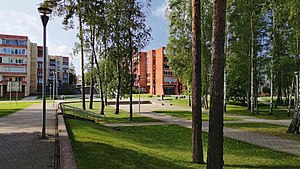
Visaginas
City in Aukštaitija, Lithuania
Distance: Approx. 1744 meters
Latitude and longitude: 55.598,26.438
Visaginas () is a city in northeastern Lithuania. It is the centre of Lithuania's youngest municipality, located on the north-eastern edge of the country. It was built as a town for workers engaged in the construction of the now decommissioned Ignalina Nuclear Power Plant.
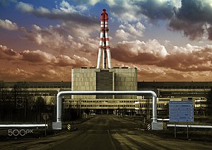
Ignalina Nuclear Power Plant
Decommissioned nuclear power plant in Visaginas Municipality, Lithuania
Distance: Approx. 9424 meters
Latitude and longitude: 55.60444444,26.56
The Ignalina Nuclear Power Plant (Lithuanian: Ignalinos atominė elektrinė, IAE) is a decommissioned two-unit RBMK-1500 nuclear power station in Visaginas Municipality, Lithuania. It was named after the nearby city of Ignalina. Due to the plant's similarities to the infamous Chernobyl Nuclear Power Plant in both reactor design and lack of a robust containment building, Lithuania agreed to close the plant as part of its agreement of accession to the European Union.

Rimšė
Town in Aukštaitija, Lithuania
Distance: Approx. 8865 meters
Latitude and longitude: 55.52222222,26.44444444
Rimšė (Polish: Rymszany) is a town in the Ignalina district municipality, Utena County, Lithuania, center of the Rimšė Eldership. In the interwar period it belonged to the Wilno Land/Wilno Voivodeship of the Second Polish Republic, together with the municipality (gmina) of which it was the capital: Rymszany Municipality.
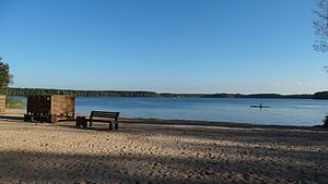
Visaginas (lake)
Distance: Approx. 1586 meters
Latitude and longitude: 55.58777778,26.42472222
Lake Visaginas is located south of the town of Visaginas in eastern Lithuania.
Visaginas Municipality
Municipality in Aukštaitija, Lithuania
Distance: Approx. 6341 meters
Latitude and longitude: 55.58666667,26.50861111
The Visaginas Municipality (Lithuanian: Visagino savivaldybė) is one of the 60 municipalities of Lithuania, situated in the north-east of the country. It consists of the city of Visaginas (administrative centre of the municipality), 16 villages (kaimai) and one farmstead (viensėdis). It has significant Russian minority population in Lithuania, with half of the population claiming Russian ethnicity.

Dūkštas Manor
Distance: Approx. 8291 meters
Latitude and longitude: 55.54361111,26.32333333
Dūkštas Manor is a former residential manor in Dūkšteliai village, Ignalina District Municipality, Lithuania. Reconstruction works of the manor began in 2005; however, it was stuck until 2010 when it was continued.
Weather in this IP's area
few clouds
6 Celsius
4 Celsius
6 Celsius
6 Celsius
1031 hPa
59 %
1031 hPa
1010 hPa
10000 meters
2.7 m/s
4.85 m/s
149 degree
19 %
07:51:15
18:07:20