5.183.0.186 - IP Lookup: Free IP Address Lookup, Postal Code Lookup, IP Location Lookup, IP ASN, Public IP
Country:
Region:
City:
Location:
Time Zone:
Postal Code:
IP information under different IP Channel
ip-api
Country
Region
City
ASN
Time Zone
ISP
Blacklist
Proxy
Latitude
Longitude
Postal
Route
Luminati
Country
Region
lu
City
vitznau
ASN
Time Zone
Europe/Zurich
ISP
netconnect AG
Latitude
Longitude
Postal
IPinfo
Country
Region
City
ASN
Time Zone
ISP
Blacklist
Proxy
Latitude
Longitude
Postal
Route
IP2Location
5.183.0.186Country
Region
aargau
City
wurenlos
Time Zone
Europe/Zurich
ISP
Language
User-Agent
Latitude
Longitude
Postal
db-ip
Country
Region
City
ASN
Time Zone
ISP
Blacklist
Proxy
Latitude
Longitude
Postal
Route
ipdata
Country
Region
City
ASN
Time Zone
ISP
Blacklist
Proxy
Latitude
Longitude
Postal
Route
Popular places and events near this IP address

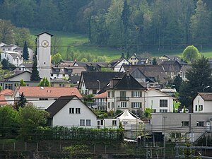
Würenlos
Municipality in Aargau, Switzerland
Distance: Approx. 896 meters
Latitude and longitude: 47.45,8.36666667
Würenlos is a municipality in the district of Baden in the canton of Aargau in Switzerland. It lies north of the river Limmat, next to the canton of Zürich, located in the Limmat Valley (German: Limmattal).
Killwangen
Municipality in Aargau, Switzerland
Distance: Approx. 1459 meters
Latitude and longitude: 47.43333333,8.35
Killwangen is a municipality in the district of Baden in the canton of Aargau in Switzerland.
Spreitenbach
Municipality in Aargau, Switzerland
Distance: Approx. 2836 meters
Latitude and longitude: 47.41666667,8.36666667
Spreitenbach (High Alemannic: Spräitebach) is a municipality in the district of Baden in the canton of Aargau in Switzerland, located in the Limmat Valley (German: Limmattal). It lies southeast of the district center, directly on the border with the canton of Zurich. It is one of the smallest cities in Switzerland.

Dänikon
Municipality in Zurich, Switzerland
Distance: Approx. 2821 meters
Latitude and longitude: 47.45,8.4
Dänikon is a municipality in the district of Dielsdorf in the canton of Zürich in Switzerland.
Hüttikon
Municipality in Zurich, Switzerland
Distance: Approx. 1675 meters
Latitude and longitude: 47.45,8.38333333
Hüttikon is a municipality in the district of Dielsdorf in the canton of Zürich in Switzerland.
Otelfingen
Municipality in Zurich, Switzerland
Distance: Approx. 3084 meters
Latitude and longitude: 47.46666667,8.38333333
Otelfingen is a municipality in the district of Dielsdorf in the canton of Zürich in Switzerland.
Oetwil an der Limmat
Municipality in Zurich, Switzerland
Distance: Approx. 2853 meters
Latitude and longitude: 47.43333333,8.4
Oetwil an der Limmat is a municipality in the district of Dietikon in the canton of Zürich in Switzerland, located in the Limmat Valley (German: Limmattal).
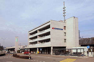
Killwangen-Spreitenbach railway station
Railway station in Killwangen, Switzerland
Distance: Approx. 1239 meters
Latitude and longitude: 47.43330556,8.35430556
Killwangen-Spreitenbach railway station (German: Bahnhof Killwangen-Spreitenbach) is a railway station in the municipality of Killwangen in the Swiss canton of Aargau. As the name suggests, the station also serves the adjacent municipality of Spreitenbach. The station is located on the Zürich–Baden railway line, just east of the point where the newer route via the Heitersberg Tunnel diverges from the original line via Baden.

Neuenhof railway station
Railway station in Neuenhof, Switzerland
Distance: Approx. 2656 meters
Latitude and longitude: 47.45036667,8.33130556
Neuenhof railway station (German: Bahnhof Neuenhof) is a railway station in the municipality of Neuenhof in the Swiss canton of Aargau. The station is located on the Zürich–Baden railway.

Würenlos railway station
Railway station in Würenlos, Switzerland
Distance: Approx. 631 meters
Latitude and longitude: 47.445649,8.357871
Würenlos is a railway station in the municipality of Würenlos in the Swiss canton of Aargau. The station is located on the Furttal line. The station is served by service S6 of the Zurich S-Bahn.

Otelfingen railway station
Railway station in Otelfingen, Switzerland
Distance: Approx. 2233 meters
Latitude and longitude: 47.454665,8.387525
Otelfingen is a railway station in Switzerland. The station is situated in the municipality of Otelfingen. The station is located on the Furttal railway line between Wettingen and Zürich Oerlikon stations.
Otelfingen Golfpark railway station
Railway station in Otelfingen, Switzerland
Distance: Approx. 3229 meters
Latitude and longitude: 47.455756,8.402245
Otelfingen Golfpark is a railway station in Switzerland. The station is situated in the municipality of Otelfingen. The station is located on the Furttal railway line and is a stop of the Zurich S-Bahn served by line S6.
Weather in this IP's area
few clouds
-3 Celsius
-3 Celsius
-4 Celsius
-2 Celsius
1033 hPa
81 %
1033 hPa
977 hPa
10000 meters
1.03 m/s
30 degree
20 %


