Country:
 France
Region:
City:
Latitude and Longitude:
Time Zone:
Postal Code:
IP information under different IP Channel
ip-api
Country
Region
City
ASN
Time Zone
ISP
Blacklist
Proxy
Latitude
Longitude
Postal
Route
IPinfo
Country
Region
City
ASN
Time Zone
ISP
Blacklist
Proxy
Latitude
Longitude
Postal
Route
MaxMind
Country
Region
City
ASN
Time Zone
ISP
Blacklist
Proxy
Latitude
Longitude
Postal
Route
Luminati
Country
FRASN
Time Zone
Europe/Paris
ISP
Abaclouda SAS
Latitude
Longitude
Postal
db-ip
Country
Region
City
ASN
Time Zone
ISP
Blacklist
Proxy
Latitude
Longitude
Postal
Route
ipdata
Country
Region
City
ASN
Time Zone
ISP
Blacklist
Proxy
Latitude
Longitude
Postal
Route
Popular places and events near this IP address

Place de la Bastille
Square in Paris, France
Distance: Approx. 229 meters
Latitude and longitude: 48.85305556,2.36916667
The Place de la Bastille (French pronunciation: [plas də la bastij]) is a square in Paris where the Bastille prison once stood, until the storming of the Bastille and its subsequent physical destruction between 14 July 1789 and 14 July 1790 during the French Revolution. No vestige of the prison remains. The square straddles 3 arrondissements of Paris, namely the 4th, 11th and 12th.

Opéra Bastille
French opera house
Distance: Approx. 140 meters
Latitude and longitude: 48.85194444,2.37055556
The Opéra Bastille (French: [ɔpeʁa bastij] , "Bastille Opera House") is a modern opera house in the 12th arrondissement of Paris, France. Inaugurated in 1989 as part of President François Mitterrand's Grands Travaux, it became the main facility of the Paris National Opera, France's principal opera company, alongside the older Palais Garnier; most opera performances are shown at the Bastille along with some ballet performances and symphony concerts, while Palais Garnier presents a mix of opera and ballet performances. Designed by Uruguayan architect Carlos Ott, it is situated facing Place de la Bastille.

Bastille station (Paris Métro)
Paris Métro station
Distance: Approx. 232 meters
Latitude and longitude: 48.853082,2.369077
Bastille (French pronunciation: [bastij] ) is a station on Line 1, Line 5 and Line 8 of the Paris Métro. Located under the Place de la Bastille and near the former location of the Bastille, it is situated on the border of the 4th, 11th and 12th arrondissement.
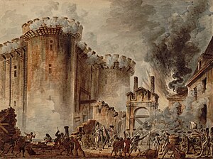
Storming of the Bastille
Major event of the French Revolution
Distance: Approx. 229 meters
Latitude and longitude: 48.85305556,2.36916667
The Storming of the Bastille (French: Prise de la Bastille [pʁiz də la bastij]) occurred in Paris, France, on 14 July 1789, when revolutionary insurgents attempted to storm and seize control of the medieval armoury, fortress and political prison known as the Bastille. After four hours of fighting and 94 deaths the insurgents were able to enter the Bastille. The governor de Launay and several members of the garrison were killed after surrender.

July Column
Victory column in Paris
Distance: Approx. 229 meters
Latitude and longitude: 48.85305556,2.36916667
The July Column (French: Colonne de Juillet) is a monumental column in Paris commemorating the Revolution of 1830. It stands in the center of the Place de la Bastille and celebrates the Trois Glorieuses — the 'three glorious' days of 27–29 July 1830 that saw the fall of Charles X, King of France, and the commencement of the July Monarchy of Louis-Philippe, King of the French. It was built between 1835 and 1840.

Gare de la Bastille
Demolished railway station in Paris, France
Distance: Approx. 182 meters
Latitude and longitude: 48.8525,2.37027778
The Gare de la Bastille was a railway station on the Place de la Bastille in the 12th arrondissement of Paris, France. The station was opened in 1859 and served as the terminus of the 55-kilometre (34 mi)-long line to Vincennes and Verneuil-l'Étang. The line was opened only to serve the Fort de Vincennes; it was extended to La Varenne and later to Brie-Comte-Robert.

Bassin de l'Arsenal
Distance: Approx. 221 meters
Latitude and longitude: 48.849475,2.36736667
The Bassin de l'Arsenal (also known as the Port de l'Arsenal) is a boat basin in Paris. It links the Canal Saint-Martin, which begins at the Place de la Bastille, to the Seine, at the Quai de la Rapée. A component of the Réseau des Canaux Parisiens (Parisian Canal Network), it forms part of the boundary between the 4th and the 12th arrondissements.
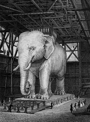
Elephant of the Bastille
Monument in Paris between 1813 and 1846
Distance: Approx. 229 meters
Latitude and longitude: 48.85305556,2.36916667
The Elephant of the Bastille was a monument in Paris which existed between 1813 and 1846. Originally conceived in 1808 by Napoleon I, the colossal statue was intended to be created out of bronze and placed in the Place de la Bastille, but only a plaster full-scale model was built. At 24 m (78 ft) in height, the model itself became a recognisable construction and was immortalised by Victor Hugo in his novel Les Misérables (1862) in which it is used as a shelter by the street urchin Gavroche.

Jardin du port de l'Arsenal
Park in Paris
Distance: Approx. 232 meters
Latitude and longitude: 48.84916667,2.36777778
The Jardin du Bassin de l'Arsenal is a public park in the 12th arrondissement of Paris, located on the east bank of the Canal Saint-Martin between the Place de la Bastille and the Seine. It was created in 1983. The access to the park is from boulevard de la Bastille.

Rue de Charenton
Street in Paris, France
Distance: Approx. 204 meters
Latitude and longitude: 48.8522,2.3714
The Rue de Charenton is a historic street in the 12th arrondissement of Paris, France. Several buildings along the street have been listed as official historical monuments by the French Ministry of Culture, namely numbers 23-25, number 35, numbers 49-51, numbers 59-61, and number 85 bis.

Fontaine de la Régénération
Distance: Approx. 234 meters
Latitude and longitude: 48.8531,2.3691
The fontaine de la Régénération or fontaine d'Isis is a monument erected in 1793 at the former site of the Bastille in Paris, during a festival to commemorate the anniversary of 10 August, 1792. It featured a statue of goddess Isis flanked by two lions, with water springing from her breasts.

Fondation pour l'audition
French foundation
Distance: Approx. 220 meters
Latitude and longitude: 48.85015106,2.37200093
The Fondation pour l'audition is a French scientific foundation for research about hearing impairment. The foundation is located in the 12th arrondissement of Paris.
Weather in this IP's area
broken clouds
15 Celsius
15 Celsius
14 Celsius
15 Celsius
1014 hPa
89 %
1014 hPa
1009 hPa
10000 meters
3.13 m/s
3.13 m/s
320 degree
75 %
08:15:41
18:55:13