Country:
Region:
City:
Latitude and Longitude:
Time Zone:
Postal Code:
IP information under different IP Channel
ip-api
Country
Region
City
ASN
Time Zone
ISP
Blacklist
Proxy
Latitude
Longitude
Postal
Route
Luminati
Country
ASN
Time Zone
Europe/Rome
ISP
Timenet SpA
Latitude
Longitude
Postal
IPinfo
Country
Region
City
ASN
Time Zone
ISP
Blacklist
Proxy
Latitude
Longitude
Postal
Route
db-ip
Country
Region
City
ASN
Time Zone
ISP
Blacklist
Proxy
Latitude
Longitude
Postal
Route
ipdata
Country
Region
City
ASN
Time Zone
ISP
Blacklist
Proxy
Latitude
Longitude
Postal
Route
Popular places and events near this IP address

Sack of Rome (1527)
Habsburg siege and subsequent sack of Papal Rome
Distance: Approx. 1077 meters
Latitude and longitude: 41.83333333,12.5
The Sack of Rome, then part of the Papal States, followed the capture of Rome on 6 May 1527 by the mutinous troops of Charles V, Holy Roman Emperor, during the War of the League of Cognac. Charles V only intended to threaten military action to make Pope Clement VII come to his terms. However, most of the Imperial army (14,000 Germans, including Lutherans, 6,000 Spaniards and some Italians) were largely unpaid.

Museum of Roman Civilization
Archeological museum in Rome, Italy
Distance: Approx. 923 meters
Latitude and longitude: 41.83194444,12.47805556
The Museum of Roman Civilization (Italian: Museo della Civiltà Romana) is a museum in the Esposizione Universale Roma district of Rome devoted to aspects of Ancient Roman Civilization. The museum has been closed for renovation since 2014.

Tre Fontane Abbey
Roman Catholic abbey in Rome
Distance: Approx. 404 meters
Latitude and longitude: 41.83444444,12.48333333
Tre Fontane Abbey (English: Three Fountains Abbey; Latin: Abbatia trium fontium ad Aquas Salvias), or the Abbey of Saints Vincent and Anastasius, is a Roman Catholic abbey in Rome, held by monks of the Cistercian Order of the Strict Observance, better known as Trappists. It is known for raising the lambs whose wool is used to weave the pallia of new metropolitan archbishops. The pope blesses the lambs on the feast of Saint Agnes on January 21.

Gesù Buon Pastore alla Montagnola
Church in Rome, Italy
Distance: Approx. 1161 meters
Latitude and longitude: 41.84583333,12.48222222
Gesù Buon Pastore alla Montagnola is a titular church in Rome. It is located in via Luigi Perna. Its parish was established by Pope Pius XI in 1937 and placed in the care of the Fathers of the Missionary Institute of the Pious Society of St Paul (known as the Paulini, not to be confused with the Paulists at Santa Susanna).
Santa Maria Scala Coeli
Distance: Approx. 435 meters
Latitude and longitude: 41.8342,12.4831
Santa Maria Scala Coeli (Saint Mary of the Stairway to Heaven) is a Roman Catholic Church located on the grounds of the Tre Fontane Abbey located on Via di Acque Salvie 1 in the Quartiere Ardeatino (Q. XX.) in Rome. This is one of three churches affiliated with the Trappist monastery, and is located on a small lane, Via delle Tre Fontane, inside the abbey complex. The location of this church is held by tradition to be where St Paul the Apostle was imprisoned.

San Paolo alle Tre Fontane
Church in Rome, Italy
Distance: Approx. 413 meters
Latitude and longitude: 41.83446667,12.4832
San Paolo alle Tre Fontane (Italian), in English "St Paul at the Three Fountains" is a Roman Catholic church dedicated to Paul the Apostle, at the presumed site of his martyrdom in Rome. In Latin it is known as Sancti Pauli ad Aquas Salvias ("St Paul at Aquae Salviae"). The church located on the grounds of the Tre Fontane Abbey located on Via di Acque Salvie 1 in the Quartiere Ardeatino (Q. XX.).
Laurentina (Rome Metro)
Rome metro station
Distance: Approx. 1162 meters
Latitude and longitude: 41.82694444,12.48111111
Laurentina is the southern terminus of Line B of the Rome Metro. It is in the Giuliano-Dalmata quarter at the crossroads of Via Laurentina, Via di Vigna Murata, Viale Luca Gaurico and Largo Vittime delle Foibe Istriane The first station on the site was begun in the 1930s, but only completed and opened in 1955. This was demolished in the 1980s, and the present building opened in 1990.

LunEur
Amusement park in Rome, Italy
Distance: Approx. 954 meters
Latitude and longitude: 41.8365,12.4761
LunEur (complete name Luna Park Permanente di Roma) is an amusement park in Rome and the oldest (still operating) in Italy, dating back to 1953. It took its name from the Eur district in Rome where it is located. The park closed in 2008, a decision made by the prefetto in order to guarantee the safety of the area but it reopened in 2016.

Palazzo dei Congressi
Building in Rome
Distance: Approx. 1121 meters
Latitude and longitude: 41.83388889,12.47444444
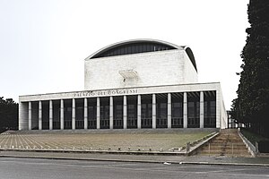
Palazzo dei Congressi (formally: Palazzo dei Ricevimenti e dei Congressi) is a building located in the EUR district of Rome, Italy. The palazzo was designed by Adalberto Libera for the 1942 Universal Exposition. Construction started in 1938 but was cancelled due to World War II. It was completed in 1954.

Pontifical University of St. Bonaventure
Distance: Approx. 863 meters
Latitude and longitude: 41.82944444,12.4825
The Pontifical University of St. Bonaventure or Pontifical Theological Faculty of Saint Bonaventure (Italian: Pontificia facoltà teologica San Bonaventura, Latin: Pontificia Facultas Theologica S. Bonaventurae), commonly called the Seraphicum, is the international study center of the Friars Minor Conventual in Rome. As a Pontifical faculty, the Seraphicum is governed by the Holy See according to the Apostolic Constitution Sapientia christiana.
San Vigilio, Rome
Church in Rome, Italy
Distance: Approx. 837 meters
Latitude and longitude: 41.82953661,12.49228265
The church of San Vigilio in Rome is a Catholic place of worship located on Via Paolo Di Dono serving the parish of that name. Its eponymous patron is Saint Vigilius of Trent. The parish was erected on 22 May 1968 by Cardinal Vicar Angelo Dell'Acqua and entrusted first to the clergy of the Archdiocese of Trento and then to the diocesan clergy of the Diocese of Rome.
Santi Martiri dell'Uganda a Poggio Ameno
Church in Rome, Italy
Distance: Approx. 1034 meters
Latitude and longitude: 41.8453,12.4901
Santi Martiri dell'Uganda a Poggio Ameno is a 20th-century parochial church and titular church in Rome, dedicated to the Uganda Martyrs.
Weather in this IP's area
few clouds
19 Celsius
18 Celsius
17 Celsius
19 Celsius
1012 hPa
71 %
1012 hPa
1008 hPa
10000 meters
4.12 m/s
210 degree
20 %
07:03:37
16:47:14

