Country:
Region:
City:
Latitude and Longitude:
Time Zone:
Postal Code:
IP information under different IP Channel
ip-api
Country
Region
City
ASN
Time Zone
ISP
Blacklist
Proxy
Latitude
Longitude
Postal
Route
Luminati
Country
ASN
Time Zone
Europe/Bucharest
ISP
Caprariu Ioana-Lidia Persoana Fizica Autorizata
Latitude
Longitude
Postal
IPinfo
Country
Region
City
ASN
Time Zone
ISP
Blacklist
Proxy
Latitude
Longitude
Postal
Route
db-ip
Country
Region
City
ASN
Time Zone
ISP
Blacklist
Proxy
Latitude
Longitude
Postal
Route
ipdata
Country
Region
City
ASN
Time Zone
ISP
Blacklist
Proxy
Latitude
Longitude
Postal
Route
Popular places and events near this IP address

Obor
Square and the surrounding district of Bucharest, the capital of Romania
Distance: Approx. 1572 meters
Latitude and longitude: 44.45042222,26.12973056
Obor is the name of a square and the surrounding district of Bucharest, the capital of Romania. There is also a Bucharest Metro station (on the M1 line) named Obor, which lies in this area. The district is near the Colentina and Moșilor neighborhoods.

Piața Iancului metro station
Bucharest metro station
Distance: Approx. 1722 meters
Latitude and longitude: 44.44089,26.13287
Piața Iancului is a metro station in Bucharest. It is located in the Iancului district near the Iulia Hasdeu National College, on the Pache Popescu/Șoseaua Iancului – Șoseaua Mihai Bravu junction. Lines served by STB are 1, 10, 46 and 55 (trams), 135, 311, 330 and 335 (buses).

Pantelimon, Bucharest
Distance: Approx. 1188 meters
Latitude and longitude: 44.44263333,26.15911944
Pantelimon is a neighbourhood located in north-eastern Bucharest, Romania, in Sector 2. Outside Bucharest, there is an adjacent town named Pantelimon, administered separately. The Pantelimon district is named after Saint Pantaleon (Pantelimon in Romanian), and hosts Arena Națională, the largest football stadium in Romania.

Colentina, Bucharest
Neighborhood in Bucharest, Romania
Distance: Approx. 1767 meters
Latitude and longitude: 44.46666667,26.15
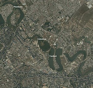
Colentina is a neighbourhood in Bucharest's Sector 2. It is located on the north-east of the city and is named after the nearby Colentina River.
Stadionul Național (1953)
Romanian multi-purpose stadium
Distance: Approx. 1549 meters
Latitude and longitude: 44.437,26.152
Stadionul Național (Romanian pronunciation: [stadiˈonul natsi.oˈnal]; "The National Stadium") was a multi-purpose stadium in Bucharest, Romania. The stadium held 60,120 people.
Doamna Ghica Plaza
Distance: Approx. 351 meters
Latitude and longitude: 44.45182,26.14532
Doamna Ghica Plaza (Romfelt Plaza) is a large residential building complex located in Bucharest, Romania. The complex is composed of nine buildings with a total surface of 132,000 m2 (1,420,000 sq ft), the tallest tower having 24 floors and a height of 80 metres (260 ft).

Arena Națională
Football stadium in Bucharest
Distance: Approx. 1530 meters
Latitude and longitude: 44.43722222,26.1525
The National Arena (Romanian: Arena Națională) is a retractable roof football stadium in Bucharest, Romania. It opened in 2011 on the site of the original National Stadium, which was demolished between 2007 and 2008. The stadium hosts major football matches including home matches of the Romania National Football Team, and usually Romanian Cup Final.

Iancului
District of Bucharest, Romania
Distance: Approx. 1633 meters
Latitude and longitude: 44.441394,26.133728
Iancului is the name of a district in Sector 2 (Bucharest) situated in the northeastern part of Bucharest, the capital of Romania. Piața Iancului is also the name of an intersection in the same district, and has a connection to the Piața Iancului metro station. The name "Iancu" comes from a Romanian revolutionary, Avram Iancu.

Lake Fundeni
Distance: Approx. 930 meters
Latitude and longitude: 44.451122,26.161194
Lake Fundeni is a man-made lake on the Colentina River in Bucharest, Sector 2. It has a surface of 35 ha (86 acres), length of 2.1 km (1.3 mi), width of 200–800 m, a depth between 1 and 5 meters, and a volume of 800,000 m3 (1,000,000 cu yd). In the middle of the lake there is an island with a surface area of 3.16 ha (7.8 acres).

Fundeni, Bucharest
Distance: Approx. 1570 meters
Latitude and longitude: 44.46074,26.163511
Fundeni is a district in Sector 2 of Bucharest, Romania. It is situated in the northeastern outskirts of the city, on the left bank of the Colentina River, downstream of Plumbuita Monastery, and near the Fundeni Lake that was formed on the river. On its west and north-west are located the Colentina and Andronache neighbourhoods, on its north the town of Voluntari and on its east the commune of Dobroești.

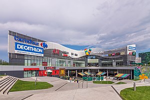
Veranda Mall
Shopping mall
Distance: Approx. 1572 meters
Latitude and longitude: 44.450422,26.129731
Veranda Mall is a shopping mall located in Bucharest, Romania, in the Obor neighborhood. It lies on Ziduri Moși Street 23, close to the Obor metro station, and it was inaugurated on October 27, 2016. The shopping mall was developed by Professional Imo Partners SA (formerly known as Prodplast Imobiliare S.A.), following a €60 million investment, and it is currently owned by the Pogonaru family.

Popa Nan Church
Heritage site in Bucharest, Romania
Distance: Approx. 1637 meters
Latitude and longitude: 44.464833,26.155667
The Popa Nan Church (Romanian: Biserica Popa Nan) is a Romanian Orthodox church located at 47A Popa Nan Street in Bucharest, Romania. It is dedicated to Saints Constantine and Helena. The first small, single-domed church on the site was built in 1719.
Weather in this IP's area
clear sky
4 Celsius
1 Celsius
2 Celsius
4 Celsius
1032 hPa
73 %
1032 hPa
1023 hPa
10000 meters
3.09 m/s
80 degree
06:58:22
16:59:36
