5.153.134.164 - IP Lookup: Free IP Address Lookup, Postal Code Lookup, IP Location Lookup, IP ASN, Public IP
Country:
Region:
City:
Location:
Time Zone:
Postal Code:
ISP:
ASN:
language:
User-Agent:
Proxy IP:
Blacklist:
IP information under different IP Channel
ip-api
Country
Region
City
ASN
Time Zone
ISP
Blacklist
Proxy
Latitude
Longitude
Postal
Route
db-ip
Country
Region
City
ASN
Time Zone
ISP
Blacklist
Proxy
Latitude
Longitude
Postal
Route
IPinfo
Country
Region
City
ASN
Time Zone
ISP
Blacklist
Proxy
Latitude
Longitude
Postal
Route
IP2Location
5.153.134.164Country
Region
donetska oblast
City
chystiakove
Time Zone
Europe/Kiev
ISP
Language
User-Agent
Latitude
Longitude
Postal
ipdata
Country
Region
City
ASN
Time Zone
ISP
Blacklist
Proxy
Latitude
Longitude
Postal
Route
Popular places and events near this IP address
Shakhtarsk
City in Donetsk Oblast, Ukraine
Distance: Approx. 9591 meters
Latitude and longitude: 48.04694444,38.46861111
Shakhtarsk (Ukrainian: Шахтарськ, IPA: [ʃɐxˈtɑrsʲk]) or Shakhtyorsk (Russian: Шахтёрск) is a city in Horlivka Raion, Donetsk Oblast, eastern Ukraine, currently occupied by Russia. Regionally, the city is the administrative center of the Shakhtarsk urban hromada. Population: 48,208 (2022 estimate).

Chystiakove
City in Donetsk Oblast, Ukraine
Distance: Approx. 2888 meters
Latitude and longitude: 48.02194444,38.62638889
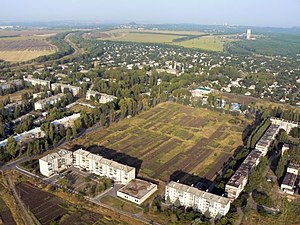
Chystiakove (Ukrainian: Чистякове IPA: [t͡ʃɪsʲtʲɐˈkɔwe] , Russian: Чистяково), formerly Torez (Ukrainian: Торез, Russian: Торез) until 2016, is a city in Donetsk Oblast, in eastern Ukraine. The city is a center of the regional coal industry and much of its economy relies on mining, despite a recent drop in the number of employed miners. The city has a population of 53,462 (2022 estimate).

Shakhtarsk Raion
Former subdivision of Donetsk Oblast, Ukraine, in use by the Donetsk People's Republic
Distance: Approx. 9454 meters
Latitude and longitude: 48.00638889,38.47952778
Shakhtarsk Raion (Ukrainian: Шахтарський район) was one of the raions of Donetsk Oblast, located in eastern Ukraine. The administrative center of the raion was the city of Shakhtarsk, which was incorporated separately as a city of oblast significance and was not part of the raion. The raion was abolished on 18 July 2020 as part of the administrative reform of Ukraine, which reduced the number of raions of Donetsk Oblast to eight.
Balochne
Place in Donetsk Oblast, Ukraine
Distance: Approx. 9153 meters
Latitude and longitude: 48.11583333,38.55388889
Balochne (Ukrainian: Балочне) is a rural settlement in Horlivka Raion, Donetsk Oblast, eastern Ukraine. As of 2001 it had a population of 18 people.
Hirne, Horlivka Raion, Donetsk Oblast
Village in Donetsk Oblast, Ukraine
Distance: Approx. 3495 meters
Latitude and longitude: 48.03722222,38.55
Hirne (Ukrainian: Гірне) is a settlement in eastern Ukraine. It is located in the Horlivka Raion of Donetsk Oblast. While de facto in Ukraine, since 2014, the village has been controlled by the unrecognized Donetsk People's Republic.
Kontarne
Urban locality in Donetsk Oblast, Ukraine
Distance: Approx. 8310 meters
Latitude and longitude: 48.08638889,38.51083333
Kontarne (Ukrainian: Контарне) is a rural settlement in Shakhtarsk urban hromada, Horlivka Raion, Donetsk Oblast, eastern Ukraine. Population: 1,421 (2022 estimate).
Kulykivske, Donetsk Oblast
Urban locality in Donetsk Oblast, Ukraine
Distance: Approx. 8929 meters
Latitude and longitude: 48.10972222,38.54083333
Kulykivske (Ukrainian: Куликівське), formerly known as Moskovske (Московське), is a rural settlement in Shakhtarsk urban hromada, Horlivka Raion, Donetsk Oblast, eastern Ukraine. Population: 624 (2022 estimate). On 19 September 2024, the Verkhovna Rada voted to rename Moskovske to Kulykivske.

Sieverne, Horlivka Raion, Donetsk Oblast
Urban locality in Donetsk Oblast, Ukraine
Distance: Approx. 8932 meters
Latitude and longitude: 48.08583333,38.69416667
Sieverne (Ukrainian: Сєверне) is a rural settlement in Snizhne urban hromada, Horlivka Raion, Donetsk Oblast, eastern Ukraine. Population: 9,832 (2022 estimate).
Pelahiivka, Donetsk Oblast
Urban locality in Donetsk Oblast, Ukraine
Distance: Approx. 6793 meters
Latitude and longitude: 48.09888889,38.61277778
Pelahiivka (Ukrainian: Пелагіївка) is a rural settlement in Chystiakove urban hromada, Horlivka Raion, Donetsk Oblast, eastern Ukraine. Population: 17,833 (2022 estimate).
Weather in this IP's area
few clouds
-3 Celsius
-10 Celsius
-3 Celsius
-3 Celsius
1039 hPa
70 %
1039 hPa
1014 hPa
10000 meters
7.02 m/s
9.98 m/s
59 degree
17 %
