5.153.131.229 - IP Lookup: Free IP Address Lookup, Postal Code Lookup, IP Location Lookup, IP ASN, Public IP
Country:
 Ukraine
Region:
City:
Location:
Time Zone:
Postal Code:
ISP:
ASN:
language:
User-Agent:
Proxy IP:
Blacklist:
IP information under different IP Channel
ip-api
Country
Region
City
ASN
Time Zone
ISP
Blacklist
Proxy
Latitude
Longitude
Postal
Route
db-ip
Country
Region
City
ASN
Time Zone
ISP
Blacklist
Proxy
Latitude
Longitude
Postal
Route
IPinfo
Country
Region
City
ASN
Time Zone
ISP
Blacklist
Proxy
Latitude
Longitude
Postal
Route
IP2Location
5.153.131.229Country
uaRegion
donetska oblast
City
vuhlehirs'k
Time Zone
Europe/Kiev
ISP
Language
User-Agent
Latitude
Longitude
Postal
ipdata
Country
Region
City
ASN
Time Zone
ISP
Blacklist
Proxy
Latitude
Longitude
Postal
Route
Popular places and events near this IP address

Debaltseve
City in Donetsk Oblast, Ukraine
Distance: Approx. 9540 meters
Latitude and longitude: 48.33333333,38.4
Debaltseve (Ukrainian: Дебальцеве, IPA: [deˈbɑlʲt͡sewe]) or Debaltsevo (Russian: Дебальцево), is a city in Horlivka Raion, Donetsk Oblast, Ukraine, currently occupied by Russia as part of the Donetsk People's Republic. The city is situated on the eastern edge of Donetsk Oblast, and borders Luhansk Oblast. Population: 24,209 (2022 estimate).

Vuhlehirsk
City in Donetsk Oblast, Ukraine
Distance: Approx. 609 meters
Latitude and longitude: 48.31,38.27
Vuhlehirsk (Ukrainian: Вуглегірськ, pronounced [wʊɦɫeˈɦ⁽ʲ⁾irsʲk]; Russian: Углегорск, romanized: Uglegorsk) is a city in Horlivka Raion, Donetsk Oblast (province) of Ukraine. Vuhlehirsk had a population of 8,226 in 2011; more recently, its population was estimated to be 7,294 (2022 estimate). Vuhlehirsk is a district-level city in the Donetsk region, subordinated to the Yenakiieve city council.
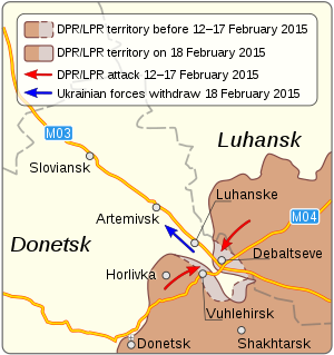
Battle of Debaltseve
2015 battle in the Donbas war
Distance: Approx. 8968 meters
Latitude and longitude: 48.3799,38.3454
The Battle of Debaltseve was a military confrontation in the city of Debaltseve, Donetsk Oblast, between the pro-Russian separatist forces of the Donetsk People's Republic (DPR) and Luhansk People's Republic (LPR), and the Ukrainian Armed Forces, starting in mid-January 2015 during the war in the Donbas region. The Russian forces composed mostly of "Wagner Group" soldiers recaptured Debaltseve, which had been under Ukrainian control since a counter-offensive by government forces in July 2014. The city lay in a "wedge" of Ukrainian-held territory bordered by the DPR on one side, and the LPR on the other, and is a vital road and railway junction.

Kalynivka, Horlivka Raion, Donetsk Oblast
Village in Donetsk Oblast, Ukraine
Distance: Approx. 4251 meters
Latitude and longitude: 48.34527778,38.30861111
Kalynivka (Ukrainian: Калинівка; Russian: Калиновка) is a village in Horlivka Raion (district) in Donetsk Oblast of eastern Ukraine, at 54.5 km NE from the centre of Donetsk city. The village was taken under control of pro-Russian forces during the War in Donbass, that started in 2014. Ukrainian forces took the village under their control in December 2016.
Lozove, Bakhmut Raion, Donetsk Oblast
Village in Donetsk Oblast, Ukraine
Distance: Approx. 7489 meters
Latitude and longitude: 48.378889,38.243889
Lozove (Ukrainian: Лозове; Russian: Лозовое) is a village in the Bakhmut Raion (district) of the Donetsk Oblast of eastern Ukraine, at 72.5 km NNE from the centre of Donetsk city. The War in Donbass, that started in mid-April 2014, has brought along both civilian and military casualties.
Lohvynove
Village in Donetsk Oblast, Ukraine
Distance: Approx. 8766 meters
Latitude and longitude: 48.375833,38.348889
Lohvynove (Ukrainian: Логвинове; Russian: Логвиново) is a village in Horlivka Raion (district) in Donetsk Oblast of eastern Ukraine, at 58.6 km NE from the centre of the Oblast administrative centre, Donetsk, at about 4 km NW from Debaltseve. The settlement was taken under control of pro-Russian forces during the War in Donbass, that started in 2014. The conflict has brought both civilian and military casualties.
Olenivka, Horlivka Raion, Donetsk Oblast
Urban-type settlement in Ukraine
Distance: Approx. 5968 meters
Latitude and longitude: 48.26111111,38.27166667
Olenivka (Ukrainian: Оленівка; Russian: Оленовка) is a rural settlement in Donetsk Oblast, eastern Ukraine. Legally, it is administratively located in Horlivka Raion, but de facto administered by the Russian occupation administration as part of Bakhmut Raion. It has a population of 751 (2022 estimate).
Bulavynske
Urban locality in Donetsk Oblast, Ukraine
Distance: Approx. 7971 meters
Latitude and longitude: 48.255,38.33361111
Bulavynske (Ukrainian: Булавинське) is a rural settlement in Horlivka Raion, Donetsk Oblast, eastern Ukraine. Population: 3,070 (2022 estimate).
Oleksandrivske
Urban locality in Donetsk Oblast, Ukraine
Distance: Approx. 4624 meters
Latitude and longitude: 48.27388889,38.28583333
Oleksandrivske (Ukrainian: Олександрівське) is a rural settlement in Horlivka Raion, Donetsk Oblast, eastern Ukraine. Population: 1,524 (2022 estimate).
Pryberezhne, Donetsk Oblast
Urban locality in Donetsk Oblast, Ukraine
Distance: Approx. 7666 meters
Latitude and longitude: 48.2525,38.31861111
Pryberezhne (Ukrainian: Прибережне) is a rural settlement in Yenakiieve urban hromada, Horlivka Raion, Donetsk Oblast, eastern Ukraine. Population: 152 (2022 estimate).
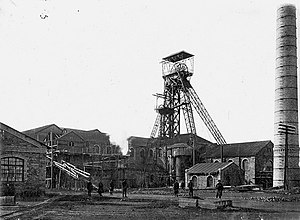
Yunkom coal mine
Mine in Bunhe, Donetsk Oblast, Ukraine
Distance: Approx. 9645 meters
Latitude and longitude: 48.22805556,38.27388889
Yunkom coal mine (Ukrainian: Шахта «Юнком», romanized: Shakhta "Yunkom", lit. '"Young Communist" coal mine'), officially named the Yuny Kommunar Mine, was a coal mine in the town of Bunhe in eastern Ukraine. The mine first opened in 1912, and was closed in 2018.
Weather in this IP's area
overcast clouds
-7 Celsius
-12 Celsius
-7 Celsius
-7 Celsius
1035 hPa
79 %
1035 hPa
1006 hPa
10000 meters
3.53 m/s
7.53 m/s
51 degree
99 %