5.152.189.69 - IP Lookup: Free IP Address Lookup, Postal Code Lookup, IP Location Lookup, IP ASN, Public IP
Country:
 Switzerland
Region:
City:
Location:
Time Zone:
Postal Code:
ISP:
ASN:
language:
User-Agent:
Proxy IP:
Blacklist:
IP information under different IP Channel
ip-api
Country
Region
City
ASN
Time Zone
ISP
Blacklist
Proxy
Latitude
Longitude
Postal
Route
db-ip
Country
Region
City
ASN
Time Zone
ISP
Blacklist
Proxy
Latitude
Longitude
Postal
Route
IPinfo
Country
Region
City
ASN
Time Zone
ISP
Blacklist
Proxy
Latitude
Longitude
Postal
Route
IP2Location
5.152.189.69Country
chRegion
aargau
City
birr
Time Zone
Europe/Zurich
ISP
Language
User-Agent
Latitude
Longitude
Postal
ipdata
Country
Region
City
ASN
Time Zone
ISP
Blacklist
Proxy
Latitude
Longitude
Postal
Route
Popular places and events near this IP address
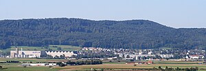
Birr, Aargau
Municipality in Aargau, Switzerland
Distance: Approx. 4 meters
Latitude and longitude: 47.43333333,8.2
Birr is a municipality in the Swiss canton of Aargau and the capital of Brugg (district). The village lies halfway between Lenzburg and Brugg. Birr has grown with its neighbour Lupfig into a conurbation.
Lupfig
Municipality in Aargau, Switzerland
Distance: Approx. 1859 meters
Latitude and longitude: 47.45,8.2
Lupfig is a municipality in the district of Brugg in canton of Aargau in Switzerland. On 1 January 2018 the former municipality of Scherz merged into the municipality of Lupfig.

Scherz
Former municipality in Aargau, Switzerland
Distance: Approx. 2243 meters
Latitude and longitude: 47.45,8.18333333
Scherz is a former municipality in the district of Brugg in canton of Aargau in Switzerland. On 1 January 2018 the former municipality of Scherz merged into the municipality of Lupfig.

Brunegg
Municipality in Aargau, Switzerland
Distance: Approx. 2237 meters
Latitude and longitude: 47.41666667,8.21666667
Brunegg is a municipality in the district of Lenzburg in the canton of Aargau in Switzerland.
Holderbank, Aargau
Municipality in Aargau, Switzerland
Distance: Approx. 2510 meters
Latitude and longitude: 47.43333333,8.16666667
Holderbank is a municipality in the district of Lenzburg in the canton of Aargau in Switzerland.
Möriken-Wildegg
Municipality in Aargau, Switzerland
Distance: Approx. 2237 meters
Latitude and longitude: 47.41666667,8.18333333
Möriken-Wildegg is a municipality in the district of Lenzburg in the canton of Aargau in Switzerland.
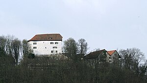
Brunegg Castle
Distance: Approx. 1652 meters
Latitude and longitude: 47.42216111,8.21448889
Brunegg castle (German: Schloss Brunegg) is a castle in the municipality of Brunegg in the canton of Aargau in Switzerland. The castle was built on a hill at the edge of the Jura mountains in the 13th century. This castle was probably built, together with Wildegg castle in nearby Wildegg, as part of the Habsburg border defenses.
Holderbank railway station
Railway station in Switzerland
Distance: Approx. 2569 meters
Latitude and longitude: 47.42862694,8.16659
Holderbank railway station (German: Bahnhof Holderbank) is a railway station in the municipality of Holderbank, in the Swiss canton of Aargau. It is an intermediate stop on the Baden–Aarau line.

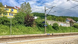
Birr railway station
Railway station in Switzerland
Distance: Approx. 1359 meters
Latitude and longitude: 47.43584,8.21764889
Birr railway station (German: Bahnhof Birr) is a railway station in the municipality of Birr, in the Swiss canton of Aargau. It is an intermediate stop on the standard gauge Brugg–Hendschiken line of Swiss Federal Railways.
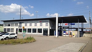
Lupfig railway station
Railway station in Switzerland
Distance: Approx. 1740 meters
Latitude and longitude: 47.44519444,8.215
Lupfig railway station (German: Bahnhof Lupfig) is a railway station in the municipality of Lupfig, in the Swiss canton of Aargau. It is an intermediate stop on the standard gauge Brugg–Hendschiken line of Swiss Federal Railways. The station was built in 1994 and replaced Birrfeld railway station, 300 m away.

Schinznach Bad railway station
Railway station in Switzerland
Distance: Approx. 3088 meters
Latitude and longitude: 47.45222222,8.17
Schinznach Bad railway station (German: Bahnhof Schinznach Bad) is a railway station in the municipality of Schinznach-Bad, in the Swiss canton of Aargau. It is an intermediate stop on the standard gauge Baden–Aarau line of Swiss Federal Railways.

Wildegg Castle
Building in Aargau, Switzerland
Distance: Approx. 2643 meters
Latitude and longitude: 47.42051944,8.17041944
Wildegg Castle is a small castle in the municipality of Möriken-Wildegg in the canton of Aargau in Switzerland.
Weather in this IP's area
moderate rain
7 Celsius
7 Celsius
6 Celsius
8 Celsius
1020 hPa
95 %
1020 hPa
967 hPa
10000 meters
1 m/s
1.04 m/s
34 degree
100 %