Country:
 France
Region:
City:
Latitude and Longitude:
Time Zone:
Postal Code:
IP information under different IP Channel
ip-api
Country
Region
City
ASN
Time Zone
ISP
Blacklist
Proxy
Latitude
Longitude
Postal
Route
IPinfo
Country
Region
City
ASN
Time Zone
ISP
Blacklist
Proxy
Latitude
Longitude
Postal
Route
MaxMind
Country
Region
City
ASN
Time Zone
ISP
Blacklist
Proxy
Latitude
Longitude
Postal
Route
Luminati
Country
FRRegion
idf
ASN
Time Zone
Europe/Paris
ISP
Flow Line Technologies SAS
Latitude
Longitude
Postal
db-ip
Country
Region
City
ASN
Time Zone
ISP
Blacklist
Proxy
Latitude
Longitude
Postal
Route
ipdata
Country
Region
City
ASN
Time Zone
ISP
Blacklist
Proxy
Latitude
Longitude
Postal
Route
Popular places and events near this IP address
Épinay-sur-Seine
Commune in Île-de-France, France
Distance: Approx. 594 meters
Latitude and longitude: 48.9553,2.3092
Épinay-sur-Seine (French pronunciation: [epinɛ syʁ sɛn] , literally Épinay on Seine) is a commune in the Seine-Saint-Denis department, in the northern suburbs of Paris, France. It is located 11.3 km (7.0 mi) from the center of Paris. The church of Notre-Dame-des-Missions-du-cygne d'Enghien, designed by Paul Tournon, may be found in the commune.

Enghien-les-Bains
Commune in Île-de-France, France
Distance: Approx. 2110 meters
Latitude and longitude: 48.9697,2.3081
Enghien-les-Bains (French pronunciation: [ɑ̃ɡɛ̃ le bɛ̃]) is a commune in the department of Val-d'Oise, France. It is located in the northern suburbs of Paris, 13.5 kilometres (8.4 mi) from the centre of Paris. Enghien-les-Bains is famous as a spa resort and a well-to-do suburb of Paris, developed in the nineteenth century around the scenic lake of Enghien.

Villeneuve-la-Garenne
Commune in Île-de-France, France
Distance: Approx. 1841 meters
Latitude and longitude: 48.9372,2.3278
Villeneuve-la-Garenne (French pronunciation: [vilnœv la ɡaʁɛn] ) is a commune in the northern suburbs of Paris, France. It is located 9.2 km (5.7 mi) from the center of Paris in the Hauts-de-Seine department in the Île-de-France region.

L'Île-Saint-Denis
Commune in Île-de-France, France
Distance: Approx. 2425 meters
Latitude and longitude: 48.9333,2.3333
L'Île-Saint-Denis (French: [lil sɛ̃ d(ə)ni] ; lit. 'Saint Denis Island') is a French commune in the northern suburbs of Paris, Île-de-France. It is located 9.4 km (5.8 mi) from the centre of Paris. The commune is entirely contained on an island of the Seine, hence its name.

Sorbonne Paris North University
French university in Paris
Distance: Approx. 2089 meters
Latitude and longitude: 48.956214,2.341933
Sorbonne Paris North University (French: Université Sorbonne Paris Nord) is a public university based in Paris, France. It is one of the thirteen universities that succeeded the University of Paris in 1968. It is a multidisciplinary university located in north of Paris, in the municipalities of Villetaneuse, Saint-Denis, La Plaine Saint-Denis, Bobigny and Argenteuil.
Lac d'Enghien
Lake in France
Distance: Approx. 2426 meters
Latitude and longitude: 48.97083333,2.3
Lac d'Enghien is a freshwater lake in France.

Gennevilliers station
Distance: Approx. 2047 meters
Latitude and longitude: 48.93333333,2.30777778
Gennevilliers is a station in Paris's express suburban rail system, the RER. It is situated in Gennevilliers, in the département of Hauts-de-Seine. An interchange with tramway T1 is available.
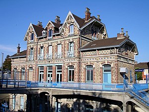
Épinay–Villetaneuse station
French railway station
Distance: Approx. 1284 meters
Latitude and longitude: 48.95828,2.32827
Épinay - Villetaneuse is a railway station located in the commune of Épinay-sur-Seine, Seine-Saint-Denis department, France. It is also adjacent to the communes of Montmagny and Deuil-la-Barre in Val d'Oise. Despite its name, the Gare d'Épinay-Villetaneuse is located approximately 1 km from Villetaneuse.

La Barre - Ormesson station
French railway station
Distance: Approx. 1697 meters
Latitude and longitude: 48.96638889,2.31638889
La Barre – Ormesson is a railway station in the commune of Deuil-la-Barre (Val-d'Oise department), France. The station is served by Transilien H trains, on the lines from Paris to Persan-Beaumont and Pontoise. The daily number of passengers was between 2,500 and 7,500 in 2002.
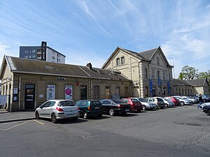
Épinay-sur-Seine station
French railway station
Distance: Approx. 947 meters
Latitude and longitude: 48.9542128,2.3022795
Épinay-sur-Seine (French: Gare d'Épinay-sur-Seine) is one of the two railway stations in the commune of Épinay-sur-Seine, Seine-Saint-Denis department, France (the other being the Gare d'Épinay-Villetaneuse). The station opened in 1908 on what was then called the Les Grésillons line, which in 1988 was incorporated into the North Branch of the RER C as part of the Vallée de Montmorency - Les Invalides connection project.
Canton of Épinay-sur-Seine
Distance: Approx. 1148 meters
Latitude and longitude: 48.95,2.33
The canton of Épinay-sur-Seine is an administrative division of the Seine-Saint-Denis department, Île-de-France region, northern France. Its borders were modified at the French canton reorganisation which came into effect in March 2015. Its seat is in Épinay-sur-Seine.
Canton of Deuil-la-Barre
Distance: Approx. 2132 meters
Latitude and longitude: 48.97,2.32
The canton of Deuil-la-Barre is an administrative division of the Val-d'Oise department, Île-de-France region, northern France. Its borders were modified at the French canton reorganisation which came into effect in March 2015. Its seat is in Deuil-la-Barre.
Weather in this IP's area
light intensity drizzle
13 Celsius
13 Celsius
12 Celsius
14 Celsius
1015 hPa
99 %
1015 hPa
1011 hPa
10000 meters
4.63 m/s
330 degree
100 %
08:16:03
18:55:17