Country:
 Belgium
Region:
City:
Latitude and Longitude:
Time Zone:
Postal Code:
IP information under different IP Channel
ip-api
Country
Region
City
ASN
Time Zone
ISP
Blacklist
Proxy
Latitude
Longitude
Postal
Route
IPinfo
Country
Region
City
ASN
Time Zone
ISP
Blacklist
Proxy
Latitude
Longitude
Postal
Route
MaxMind
Country
Region
City
ASN
Time Zone
ISP
Blacklist
Proxy
Latitude
Longitude
Postal
Route
Luminati
Country
BEASN
Time Zone
Europe/Brussels
ISP
BELNET
Latitude
Longitude
Postal
db-ip
Country
Region
City
ASN
Time Zone
ISP
Blacklist
Proxy
Latitude
Longitude
Postal
Route
ipdata
Country
Region
City
ASN
Time Zone
ISP
Blacklist
Proxy
Latitude
Longitude
Postal
Route
Popular places and events near this IP address
Statistics Belgium
Distance: Approx. 675 meters
Latitude and longitude: 50.858225,4.35566944
Statistics Belgium (abbreviated Statbel formerly known as the NSI) is part of the Federal Public Service Economy, SMEs, Self-Employed and Energy. Its legal Dutch name is Algemene Directie Statistiek, and its legal French name is Direction générale Statistique. Statistics Belgium conducts surveys among households and enterprises in Belgium.
LUCA School of Arts
Art college in Belgium
Distance: Approx. 604 meters
Latitude and longitude: 50.86149444,4.36677222
Hogeschool Sint-Lukas Brussel (the "LUCA School of Arts") is an independent Flemish art school based in the Schaerbeek municipality of Brussels, Belgium. It is a predominantly Dutch-speaking institution located on the Paleizenstraat/Rue de Palais, and at another site, within reachable distance of Brussels' North Station. The Hogeschool provides exclusively art-related university-level higher education, hence the name.
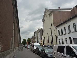
Rue d'Aerschot
Street in Schaerbeek, Belgium
Distance: Approx. 343 meters
Latitude and longitude: 50.86277778,4.36361111
The Rue d'Aerschot (French) or Aarschotstraat (Dutch) is a street in the Schaerbeek municipality of Brussels, Belgium. It is known as a hotspot of the city's underground nightlife and famous for its brothels. The street is also known for its inexpensive lodging.
Brussels International Fantastic Film Festival
Annual film festival for speculative fiction film held in Brussels, Belgium
Distance: Approx. 818 meters
Latitude and longitude: 50.86473611,4.34750556
The Brussels International Fantastic Film Festival (BIFFF), previously named Brussels International Festival of Fantastic Film (French: Festival international du film fantastique de Bruxelles, Dutch: Internationaal Festival van de Fantastische Film van Brussel) was created in 1983 as a venue for horror, thriller and science fiction films. It takes place in Brussels, every year in March. Initially organized by Annie Bozzo, Gigi Etienne, Freddy Bozzo, Georges Delmote and Guy Delmote, it now has prizes in both feature-length and short films, and also hosts an international body-painting competition.
State Security Service (Belgium)
Belgian intelligence and security agency
Distance: Approx. 744 meters
Latitude and longitude: 50.85769167,4.35516111
The State Security Service (VSSE) (known in Dutch as Staatsveiligheid; French: Sûreté de l'État) is a Belgian intelligence and security agency. Established in 1830, it is the world's oldest intelligence service. The State Security is a civilian agency under the authority of the Ministry of Justice, while the military intelligence agency, the General Information and Security Service, operates under the authority of the Ministry of Defense.
Ric's Art Boat
Distance: Approx. 626 meters
Latitude and longitude: 50.86277778,4.35033333
Ric's Art Boat and Ric's River Boat are two boats moored in the Port of Brussels, highlighting artistic activities and events, supporting initiatives for social integration and cultural entertainment projects.

Brussels-North railway station
Railway and premetro station in Brussels, Belgium
Distance: Approx. 471 meters
Latitude and longitude: 50.86,4.36166667
Brussels-North railway station (French: Gare de Bruxelles-Nord; Dutch: Station Brussel-Noord) is one of the three major railway stations in Brussels, Belgium; the other two are Brussels-Central and Brussels-South. Every regular domestic and international train (except Eurostar) passing there has a planned stop. The station has 200,000 passengers per week, mainly commuters, making it one of the busiest in Belgium.
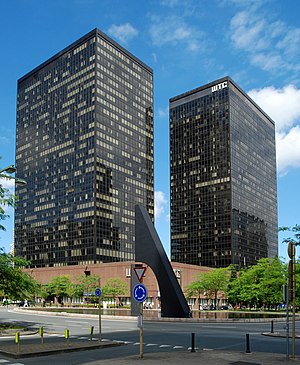
World Trade Center (Brussels)
Complex of skyscrapers in Brussels, Belgium
Distance: Approx. 345 meters
Latitude and longitude: 50.86111111,4.35694444
The World Trade Center (WTC) is a complex of skyscrapers at the corner of the Boulevard du roi Albert II/Koning Albert II-laan and the Boulevard Simon Bolivar/Simon Bolivarlaan in the Northern Quarter central business district of Brussels, Belgium. Its three towers are among the tallest buildings in Belgium. The complex was originally planned to have eight towers, all around the corner of the Boulevard du roi Albert II and the Boulevard Simon Bolivar.

Northern Quarter, Brussels
Central business district in Brussels, Belgium
Distance: Approx. 651 meters
Latitude and longitude: 50.85805556,4.35916667
The Northern Quarter (French: Quartier Nord or Espace Nord; Dutch: Noordwijk or Noordruimte) is the central business district of Brussels, Belgium. Like La Défense in Paris, the Docklands in London or the Zuidas in Amsterdam, the Northern Quarter consists of a concentrated collection of high-rise buildings where many Belgian and multinational companies have their headquarters. The Northern Quarter roughly covers the area between Willebroek Quay, railways along Brussels-North railway station and the northern side of the Small Ring (Brussels' inner ring road).

Proximus Towers
Twin skyscrapers in Brussels, Belgium
Distance: Approx. 468 meters
Latitude and longitude: 50.85972222,4.35833333
The Proximus Towers (French: Tours Proximus; Dutch: Proximustorens) are twin skyscrapers on the Boulevard du roi Albert II/Koning Albert II-laan in the Northern Quarter central business district of Brussels, Belgium. The buildings take their name from the telecommunications company Proximus. They were formerly known as the Belgacom Towers before the company's name change.

North Galaxy Towers
Twin skyscrapers in Brussels, Belgium
Distance: Approx. 280 meters
Latitude and longitude: 50.86138889,4.35916667
The North Galaxy Towers (French: Tours North Galaxy; Dutch: North Galaxytorens) are twin 28-storey skyscrapers on the Boulevard du roi Albert II/Koning Albert II-laan in the Northern Quarter central business district of Brussels, Belgium. There is a third building in the complex which is 6 storeys tall. The first two floors are shared by all three buildings.
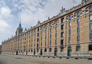
Tour & Taxis
Former industrial site, now mixed-use neighbourhood in Brussels, Belgium
Distance: Approx. 735 meters
Latitude and longitude: 50.86416667,4.34861111
Tour & Taxis (French: Tour et Taxis; Dutch: Thurn en Taxis) is a large former industrial site in Brussels, Belgium. It is situated on the embankment of the Brussels Canal in the City of Brussels, just north-west of the city centre. The location is immediately adjacent to Laeken and Molenbeek-Saint-Jean, and about 1 kilometre (0.62 miles) west from the city's Northern Quarter business district.
Weather in this IP's area
clear sky
24 Celsius
24 Celsius
23 Celsius
25 Celsius
1021 hPa
60 %
1021 hPa
1018 hPa
10000 meters
4.12 m/s
60 degree
07:24:34
19:48:04