Country:
 Switzerland
Region:
City:
Latitude and Longitude:
Time Zone:
Postal Code:
IP information under different IP Channel
ip-api
Country
Region
City
ASN
Time Zone
ISP
Blacklist
Proxy
Latitude
Longitude
Postal
Route
IPinfo
Country
Region
City
ASN
Time Zone
ISP
Blacklist
Proxy
Latitude
Longitude
Postal
Route
MaxMind
Country
Region
City
ASN
Time Zone
ISP
Blacklist
Proxy
Latitude
Longitude
Postal
Route
Luminati
Country
CHRegion
zh
City
dachsen
ASN
Time Zone
Europe/Zurich
ISP
Netcetera AG
Latitude
Longitude
Postal
db-ip
Country
Region
City
ASN
Time Zone
ISP
Blacklist
Proxy
Latitude
Longitude
Postal
Route
ipdata
Country
Region
City
ASN
Time Zone
ISP
Blacklist
Proxy
Latitude
Longitude
Postal
Route
Popular places and events near this IP address

Egg, Switzerland
Municipality in Zurich, Switzerland
Distance: Approx. 1642 meters
Latitude and longitude: 47.3,8.69027778
Egg is a municipality in the district of Uster in the canton of Zürich in Switzerland.

Greifensee (lake)
Distance: Approx. 3997 meters
Latitude and longitude: 47.35,8.68333333
Greifensee is a lake in the canton of Zürich in Switzerland.

Aabach (Greifensee)
River in Switzerland
Distance: Approx. 4191 meters
Latitude and longitude: 47.3516,8.6888
The Aabach (also Aa, or Ustermer Aa for disambiguation with the Mönchaltorfer Aa) is a minor river in the canton of Zürich, Switzerland. At a length of 11.2 kilometres (7.0 mi), it flows from Pfäffikersee to the Greifensee. Its valley is known as Aatal ("Aa Valley"), eponymous of the settlement Aathal.
Mönchaltorf
Municipality in Zurich, Switzerland
Distance: Approx. 2489 meters
Latitude and longitude: 47.31666667,8.71666667
Mönchaltorf is a municipality in the district of Uster in the canton of Zürich in Switzerland.
Uster District
District in Switzerland
Distance: Approx. 3997 meters
Latitude and longitude: 47.35,8.68333333
Uster District is one of the twelve districts of the canton of Zürich, Switzerland. Its capital is the city of Uster. The German-speaking district has a population of 135,234 (as of 31 December 2020).
Maur, Switzerland
Municipality in Zurich, Switzerland
Distance: Approx. 4203 meters
Latitude and longitude: 47.35,8.66666667
Maur is a municipality in the district of Uster in the canton of Zürich in Switzerland.

Forch
Distance: Approx. 2606 meters
Latitude and longitude: 47.325,8.65333333
Forch is a village and a mountain pass (el. 682 m (2,238 ft)) located in the municipalities of Küsnacht and Maur in the canton of Zürich, Switzerland.

Pfannenstiel (Zürich)
Mountain in Switzerland
Distance: Approx. 2670 meters
Latitude and longitude: 47.29166667,8.67138889
Pfannenstiel (el. 853 metres (2,799 ft)) is a wooded mountain respectively a region overlooking the Lake Zürich and Zürcher Oberland in the canton of Zürich in Switzerland.

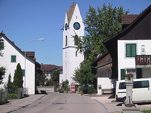
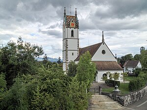
St. Antonius Church, Egg
Distance: Approx. 1650 meters
Latitude and longitude: 47.2994,8.6867
The St Antonius Church, Egg is a Catholic Church in Egg, Zürich, Switzerland, dedicated to Anthony of Padua. Because of its importance as a place of pilgrimage it has been called "little-Padua".

Kantonsschule Uster
Distance: Approx. 4179 meters
Latitude and longitude: 47.3486905,8.7054231
Kantonsschule Uster (KUS) is a gymnasium (senior high school) located in Uster, Switzerland, in the Zurich metropolitan area. Originally the school was formed in Gutenswil. Students come from several areas, including Uster and Dübendorf.

Forch railway station
Railway station in Switzerland
Distance: Approx. 2987 meters
Latitude and longitude: 47.32532,8.64794
Forch is a railway station in the Swiss canton of Zürich and the municipality of Küsnacht. It is the principal intermediate station and headquarters of the Forchbahn (FB), which is operated as Zürich S-Bahn service S18 and provides links to the city of Zürich and the nearby village of Esslingen. The station is operated by the Forchbahn, and serves the village of Forch.

Esslingen railway station
Railway station in Switzerland
Distance: Approx. 3528 meters
Latitude and longitude: 47.28776,8.7099
Esslingen is a railway station in the Swiss canton of Zürich and the municipality of Egg. It is the outer terminus of the Forchbahn (FB) from the city of Zürich, which is operated as Zürich S-Bahn service S18. The station is operated by the Forchbahn, and has three terminal platforms and a bus interchange located under an overall roof.
Weather in this IP's area
few clouds
20 Celsius
19 Celsius
17 Celsius
21 Celsius
1015 hPa
56 %
1015 hPa
953 hPa
10000 meters
3.09 m/s
100 degree
20 %
07:08:22
19:29:40