Country:
 Spain
SpainRegion:
City:
Latitude and Longitude:
Time Zone:
Postal Code:
IP information under different IP Channel
ip-api
Country
Region
City
ASN
Time Zone
ISP
Blacklist
Proxy
Latitude
Longitude
Postal
Route
IPinfo
Country
Region
City
ASN
Time Zone
ISP
Blacklist
Proxy
Latitude
Longitude
Postal
Route
MaxMind
Country
Region
City
ASN
Time Zone
ISP
Blacklist
Proxy
Latitude
Longitude
Postal
Route
Luminati
Country
ESRegion
md
City
madrid
ASN
Time Zone
Europe/Madrid
ISP
Ginernet S.l.
Latitude
Longitude
Postal
db-ip
Country
Region
City
ASN
Time Zone
ISP
Blacklist
Proxy
Latitude
Longitude
Postal
Route
ipdata
Country
Region
City
ASN
Time Zone
ISP
Blacklist
Proxy
Latitude
Longitude
Postal
Route
Popular places and events near this IP address

San Blas-Canillejas
District of Madrid in Spain
Distance: Approx. 1021 meters
Latitude and longitude: 40.426001,-3.612764
San Blas-Canillejas is a district to the east of Madrid's city centre. The population of the district is estimated in 149,909.
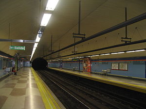
Suanzes (Madrid Metro)
Madrid Metro station
Distance: Approx. 1030 meters
Latitude and longitude: 40.4407959,-3.6268962
Suanzes [ˈswan.θes] is a station on Line 5 of the Madrid Metro, located near the Parque Marques De Suances, which derives its name from the naval engineer Juan Antonio Suanzes (1891–1977). The naming has been controversial due to Suanzes' connection to the Franco regime, and changing the name was proposed in 2017.

Torre Arias (Madrid Metro)
Madrid Metro station
Distance: Approx. 1276 meters
Latitude and longitude: 40.4437467,-3.6169981
Torre Arias [ˈtore ˈaɾjas] is a station on Line 5 of the Madrid Metro, located southeast of the Quinta de Torre Arias park and the Torre Arias castle.

García Noblejas (Madrid Metro)
Madrid Metro station
Distance: Approx. 1146 meters
Latitude and longitude: 40.4284244,-3.633304
García Noblejas [ɡaɾˈθi.a noˈβlexas] is a station on Line 7 of the Madrid Metro, on the Calle de los Hermanos García Noblejas ("Street of the García-Noblejas brothers," named for two Falangist leaders).

Simancas (Madrid Metro)
Madrid Metro station
Distance: Approx. 660 meters
Latitude and longitude: 40.4279879,-3.6257196
Simancas [siˈmaŋkas] is a station on Line 7 of the Madrid Metro, serving the Simancas barrio.

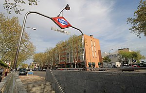
San Blas (Madrid Metro)
Madrid Metro station
Distance: Approx. 704 meters
Latitude and longitude: 40.427989,-3.6154635
San Blas [ˈsam ˈblas] is a station on Line 7 of the Madrid Metro, serving the San Blas-Canillejas barrio.
Las Musas (Madrid Metro)
Madrid Metro station
Distance: Approx. 1112 meters
Latitude and longitude: 40.432984,-3.6078807
Las Musas [las ˈmu.sas] is a station on Line 7 of the Madrid Metro, named for the nearby Calle Musas.

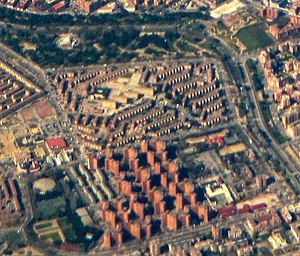
Simancas (Madrid)
City neighborhood in Madrid, Community of Madrid, Spain
Distance: Approx. 631 meters
Latitude and longitude: 40.42805556,-3.62527778
Simancas is an administrative neighborhood (barrio) of Madrid belonging to the district of San Blas-Canillejas. It has an area of 2.278418 km2 (0.879702 sq mi). As of 1 February 2020, it has a population of 28,799.
Hellín (Madrid)
City neighborhood in Madrid, Community of Madrid, Spain
Distance: Approx. 324 meters
Latitude and longitude: 40.43027778,-3.61888889
Hellín is an administrative neighborhood (barrio) of Madrid belonging to the district of San Blas-Canillejas. It has an area of 0.549031 km2 (0.211982 sq mi). As of 1 March 2020, it has a population of 9,403.

Amposta (Madrid)
City neighborhood in Madrid, Community of Madrid, Spain
Distance: Approx. 300 meters
Latitude and longitude: 40.43027778,-3.61944444
Amposta is an administrative neighborhood (barrio) of Madrid belonging to the district of San Blas-Canillejas. It has an area of 0.370250 km2 (0.142954 sq mi). As of 1 March 2020, it has a population of 8,971.

Arcos (Madrid)
City neighborhood in Madrid, Community of Madrid, Spain
Distance: Approx. 1190 meters
Latitude and longitude: 40.42388889,-3.61305556
Arcos is an administrative neighborhood (barrio) of Madrid belonging to the district of San Blas-Canillejas. It has an area of 1.305192 km2 (0.503937 sq mi). As of 1 March 2020, it has a population of 24,902.

Alameda de Osuna
Ward of Madrid in Spain
Distance: Approx. 631 meters
Latitude and longitude: 40.42805556,-3.62527778
Alameda de Osuna is a ward (barrio) of Madrid belonging to the district of Barajas.
Weather in this IP's area
thunderstorm with heavy rain
18 Celsius
17 Celsius
16 Celsius
19 Celsius
1011 hPa
71 %
1011 hPa
935 hPa
3000 meters
9.26 m/s
280 degree
75 %
07:59:23
20:17:04