Country:
 Great Britain
Region:
City:
Latitude and Longitude:
Time Zone:
Postal Code:
IP information under different IP Channel
ip-api
Country
Region
City
ASN
Time Zone
ISP
Blacklist
Proxy
Latitude
Longitude
Postal
Route
IPinfo
Country
Region
City
ASN
Time Zone
ISP
Blacklist
Proxy
Latitude
Longitude
Postal
Route
MaxMind
Country
Region
City
ASN
Time Zone
ISP
Blacklist
Proxy
Latitude
Longitude
Postal
Route
Luminati
Country
GBRegion
eng
City
oldham
ASN
Time Zone
Europe/London
ISP
Grain Communications Limited
Latitude
Longitude
Postal
db-ip
Country
Region
City
ASN
Time Zone
ISP
Blacklist
Proxy
Latitude
Longitude
Postal
Route
ipdata
Country
Region
City
ASN
Time Zone
ISP
Blacklist
Proxy
Latitude
Longitude
Postal
Route
Popular places and events near this IP address

Bolton South East (UK Parliament constituency)
UK Parliament constituency in England since 1983
Distance: Approx. 1556 meters
Latitude and longitude: 53.566,-2.4
Bolton South East was a constituency in the House of Commons . Further to the completion of the 2023 Periodic Review of Westminster constituencies, the seat was subject to boundary changes which incorporated the community of Walkden in the City of Salford. As a consequence, it was replaced with the constituency of Bolton South and Walkden, which was first contested at the 2024 general election.

Little Lever
Village in Greater Manchester, England
Distance: Approx. 553 meters
Latitude and longitude: 53.563,-2.369
Little Lever is a village in the Metropolitan Borough of Bolton, Greater Manchester, England. Within the Historic County of Lancashire, it is 2 miles (3.2 km) southeast of Bolton, 2 miles (3.2 km) west of Radcliffe and 4 miles (6.4 km) southwest of Bury. In the 19th century, the population was employed in cotton mills, paper mills, bleach works, terracotta works, a rope works and numerous collieries.
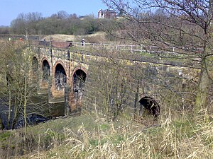
Prestolee Aqueduct
Bridge in Prestolee, Greater Manchester
Distance: Approx. 1414 meters
Latitude and longitude: 53.5525,-2.3764
Prestolee Aqueduct is a stone-built aqueduct in Prestolee, Kearsley in the Metropolitan Borough of Bolton, Greater Manchester, England. The four-arch structure was constructed in 1793 to carry the Manchester, Bolton and Bury Canal across the River Irwell. It is now preserved as a Grade II listed building.

Nob End
Site of Special Scientific Interest in the United Kingdom
Distance: Approx. 1368 meters
Latitude and longitude: 53.553,-2.379
Nob End is the site of a former waste tip which is now a Site of Special Scientific Interest and Local Nature Reserve near Little Lever and Kearsley, in Greater Manchester, England.
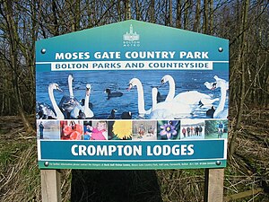
Moses Gate Country Park
Distance: Approx. 1414 meters
Latitude and longitude: 53.5527,-2.3803
Moses Gate Country Park, part of which is also known as Crompton Lodges, (National Grid Ref: SD 749063) is a 750 acre (300 hectare) site situated at Moses Gate in the Croal and Irwell Valleys 3 miles (4.8 km) south of Bolton town centre on the A6053 road which connects Farnworth to Little Lever. It is a Local Nature Reserve.
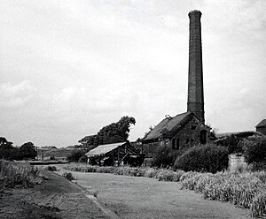
Ladyshore Colliery
Mine in
Distance: Approx. 1450 meters
Latitude and longitude: 53.556584,-2.360061
Ladyshore Colliery, originally named Back o' th Barn, was situated on the Irwell Valley fault on the Manchester Coalfield in Little Lever, then in the historic county of Lancashire, England. Founded by Thomas Fletcher Senior, the colliery opened in the 1830s and mined several types of coal. It became infamous as a result of the owners' stand against the use of safety lamps in the mines.

Bradley Fold railway station
Disused railway station in England
Distance: Approx. 919 meters
Latitude and longitude: 53.571357,-2.367237
Bradley Fold railway station served Bradley Fold on the now closed line between Bury and Bolton. The route was lost to a housing development at Bradley Fold in 1994.

Ainsworth Mill, Breightmet
Cotton mill in Greater Manchester, England
Distance: Approx. 1514 meters
Latitude and longitude: 53.5784,-2.371
Ainsworth Mill, Breightmet is a mercerising mill near the Breightmet neighborhood of Bolton, Greater Manchester. It was bought by the Lancashire Cotton Corporation in the 1940s as an attempt to develop a cotton finishing presence.
Bradley Fold
Human settlement in England
Distance: Approx. 1027 meters
Latitude and longitude: 53.572,-2.366
Bradley Fold is a small district within the Metropolitan Borough of Bury, in Greater Manchester, England. It lies midway between Bolton and Bury, approximately 3 miles from each. It forms part of the Radcliffe North ward on Bury Council, and sits within the Bury South parliamentary constituency.
St Matthew's Church, Little Lever
Church in Greater Manchester, England
Distance: Approx. 333 meters
Latitude and longitude: 53.5628,-2.3735
St Matthew's Church is in the village of Little Lever, Bolton, Greater Manchester, England. It is an active Anglican parish church in the deanery of Bolton, the archdeaconry of Bolton, and the diocese of Manchester. St Matthew's is recorded in the National Heritage List for England as a designated Grade II listed building.
Little Lever School
Academy in Greater Manchester, England
Distance: Approx. 646 meters
Latitude and longitude: 53.5617,-2.3843
Little Lever School is a mixed secondary school located in Little Lever in the English county of Greater Manchester. Little Lever school was previously a community school with a specialism in Business and Enterprise that was administered by Bolton Metropolitan Borough Council. However Little Lever School converted to academy status in December 2015 and is judged by Ofsted as 'Good' .
Little Lever Urban District
Distance: Approx. 461 meters
Latitude and longitude: 53.5632,-2.3704
Little Lever was, from 1872 to 1974, a local government district centred on the large village of Little Lever in the administrative county of Lancashire, England.
Weather in this IP's area
overcast clouds
10 Celsius
10 Celsius
9 Celsius
12 Celsius
1032 hPa
90 %
1032 hPa
1021 hPa
10000 meters
1.08 m/s
1.16 m/s
109 degree
100 %
06:47:04
19:20:55