Country:
Region:
City:
Latitude and Longitude:
Time Zone:
Postal Code:
IP information under different IP Channel
ip-api
Country
Region
City
ASN
Time Zone
ISP
Blacklist
Proxy
Latitude
Longitude
Postal
Route
Luminati
Country
Region
eng
City
blackburn
ASN
Time Zone
Europe/London
ISP
Grain Communications Limited
Latitude
Longitude
Postal
IPinfo
Country
Region
City
ASN
Time Zone
ISP
Blacklist
Proxy
Latitude
Longitude
Postal
Route
db-ip
Country
Region
City
ASN
Time Zone
ISP
Blacklist
Proxy
Latitude
Longitude
Postal
Route
ipdata
Country
Region
City
ASN
Time Zone
ISP
Blacklist
Proxy
Latitude
Longitude
Postal
Route
Popular places and events near this IP address
Hulme Grammar School
School in Oldham, England
Distance: Approx. 628 meters
Latitude and longitude: 53.5298,-2.1236
Hulme Grammar School is a private grammar school in Oldham, Lancashire, England.
Oldham Borough F.C.
Football club
Distance: Approx. 735 meters
Latitude and longitude: 53.51852222,-2.12175278
Oldham Borough F.C. was an English association football club based in Oldham, Greater Manchester, England. The club was founded in 1964 as Oldham Dew F.C., changing their name in 1985 to Oldham Town, again in 2009 to Oldham Boro before making their final name change in 2014. They were members of Division One of the North West Counties League until resigning in June 2015.
Hathershaw
Human settlement in England
Distance: Approx. 578 meters
Latitude and longitude: 53.5283,-2.1123
Hathershaw (or, archaically, Hathershaw Moor) is an urban area of Oldham, in Greater Manchester, England. It occupies a hillside to the immediate south of Oldham town centre, and is bordered by the districts of Coppice and Fitton Hill to, respectively, the north-west and south-east. Hathershaw, which has no formal boundary or extent, is bisected from north to south by the A627 road which leads to Ashton-under-Lyne.

The Hathershaw College
Secondary academy college in Oldham, Greater Manchester, England
Distance: Approx. 564 meters
Latitude and longitude: 53.5221,-2.1118
The Hathershaw College is a coeducational, Secondary Academy for 11- to 16-year-olds in Oldham, Greater Manchester, England. In 2007, Ofsted rated the school as "good". In 2010, Ofsted described it as "good with outstanding features".

Coppice, Greater Manchester
Human settlement in England
Distance: Approx. 456 meters
Latitude and longitude: 53.529,-2.119
Coppice is a locality and urban/suburban area the town of Oldham, in Greater Manchester, England. It is located to the south of Oldham town centre and is contiguous with other areas of Oldham including Hathershaw, Werneth, Hollins, Copster Hill and Primrose Bank. Coppice is the location of Hulme Grammar School and Werneth Cricket Club whose ground is known as 'The Coppice'.

Heron Mill, Hollinwood
Cotton spinning mill in Oldham, Greater Manchester, England
Distance: Approx. 529 meters
Latitude and longitude: 53.5242,-2.1268
Heron Mill is a cotton spinning mill in Hollinwood, Oldham, Greater Manchester. It was designed by architect P. S. Stott and was constructed in 1905 by the Heron Mill Company Ltd next to Durban Mill. It was taken over by the Lancashire Cotton Corporation in the 1930s and passed to Courtaulds in 1964.
Whitebank Stadium
Distance: Approx. 732 meters
Latitude and longitude: 53.51854167,-2.12174722
Whitebank Stadium, currently also known as the Vestacare Stadium for sponsorship purposes, is a rugby league and association football stadium which forms part of Limeside in Oldham, England. It is the home stadium of Avro F.C. In 2017, following a sponsorship from Vestacare, a service provider for people with learning disabilities, the stadium was renamed Vestacare Stadium.
Oasis Academy Oldham
Academy in Oldham, Greater Manchester, England
Distance: Approx. 710 meters
Latitude and longitude: 53.5231,-2.1292
Oasis Academy Oldham is a coeducational secondary school with academy status for 11- to 16-year-olds in the Hollinwood area of Oldham, Greater Manchester, England. The academy was formed from a merger of Kaskenmoor School in Hollinwood and South Chadderton School in Chadderton. The academy is sponsored by the Oasis Trust.

Hathershaw Hall
Listed building in Greater Manchester, England
Distance: Approx. 300 meters
Latitude and longitude: 53.5252,-2.1144
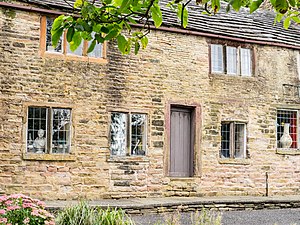
Hathershaw Hall is a 16th–17th century Grade II* listed building in Hathershaw, Oldham, Greater Manchester, England. The present structure is the single surviving range of a once considerably larger manor house. It is situated in what was the historic county of Lancashire.
Garden Suburb, Oldham
Human settlement in England
Distance: Approx. 440 meters
Latitude and longitude: 53.521,-2.12
Garden Suburb is an area of Oldham, Greater Manchester, England, 1.9 miles to the south of the town centre, contiguous with Hollins, Copster Hill, Hollinwood and Limeside.
Hollins, Oldham
Human settlement in England
Distance: Approx. 467 meters
Latitude and longitude: 53.522,-2.124
Hollins is an area of Oldham, Greater Manchester, England, 1.7 miles south of the town centre. Formerly a hamlet set amongst open moorland and farmland along Hollins Road, the 19th century growth of Oldham saw Hollins form a contiguous urban area with Hollinwood, Limeside, Garden Suburb, Werneth, Coppice and Copster Hill.
Copster Hill
Human settlement in England
Distance: Approx. 13 meters
Latitude and longitude: 53.525,-2.119
Copster Hill is a locality in the town of Oldham in Greater Manchester, lying 1.6 miles to the south of Oldham town centre. Archaically a hamlet and private estate set in open moorland and farmland along Hollins Road, the 19th-century growth of Oldham saw Copster Hill form a contiguous urban area with Hathershaw, Hollins, Garden Suburb and Coppice. The area is served by Copster Park which opened to the public in 1911.
Weather in this IP's area
broken clouds
9 Celsius
9 Celsius
9 Celsius
10 Celsius
1028 hPa
84 %
1028 hPa
1008 hPa
10000 meters
1.34 m/s
2.24 m/s
163 degree
61 %
07:12:02
16:31:58