Country:
 Great Britain
Region:
City:
Latitude and Longitude:
Time Zone:
Postal Code:
IP information under different IP Channel
ip-api
Country
Region
City
ASN
Time Zone
ISP
Blacklist
Proxy
Latitude
Longitude
Postal
Route
IPinfo
Country
Region
City
ASN
Time Zone
ISP
Blacklist
Proxy
Latitude
Longitude
Postal
Route
MaxMind
Country
Region
City
ASN
Time Zone
ISP
Blacklist
Proxy
Latitude
Longitude
Postal
Route
Luminati
Country
GBRegion
eng
City
carlisle
ASN
Time Zone
Europe/London
ISP
Grain Communications Limited
Latitude
Longitude
Postal
db-ip
Country
Region
City
ASN
Time Zone
ISP
Blacklist
Proxy
Latitude
Longitude
Postal
Route
ipdata
Country
Region
City
ASN
Time Zone
ISP
Blacklist
Proxy
Latitude
Longitude
Postal
Route
Popular places and events near this IP address

Aiketgate
Human settlement in England
Distance: Approx. 3516 meters
Latitude and longitude: 54.812,-2.809
Aiketgate is a small village in the English county of Cumbria. It is within the civil parish of Hesket. Development of wind turbines in the Eden Valley has drawn attention to Aiketgate.

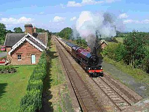
Armathwaite railway station
Railway station in Cumbria, England
Distance: Approx. 4328 meters
Latitude and longitude: 54.8094607,-2.7722766
Armathwaite is a railway station on the Settle and Carlisle Line, which runs between Carlisle and Leeds via Settle. The station, situated 9 miles 75 chains (16 km) south-east of Carlisle, serves the village of Armathwaite, Eden in Cumbria, England. It is owned by Network Rail and managed by Northern Trains.
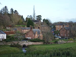
Great Corby
Human settlement in England
Distance: Approx. 4177 meters
Latitude and longitude: 54.88,-2.82
Great Corby is a village in northern Cumbria, England, above the eastern bank of a wooded gorge on the River Eden. Directly across the river from Great Corby is the village of Wetheral. The two villages are linked by a railway viaduct (Corby Bridge, popularly known as "Wetheral Viaduct").

Corby Castle
Tower House, developed into a Country House in Great Corby
Distance: Approx. 4257 meters
Latitude and longitude: 54.87971,-2.82626
Corby Castle is a Grade I listed building and ancestral home of a cadet branch of the prominent Howard family situated on the southern edge of the village of Great Corby in northern Cumbria, England.

Cumwhitton
Village in Cumbria, England
Distance: Approx. 2596 meters
Latitude and longitude: 54.85,-2.766
Cumwhitton is a small village and civil parish close to Carlisle in Cumbria, England. It lies just east of the M6 and the nearest train station is located in Wetheral, 3 miles away. Cumwhitton is often confused with the nearby village of Cumwhinton in Wetheral parish.
Cumwhinton
Village in Cumbria, England
Distance: Approx. 4092 meters
Latitude and longitude: 54.867,-2.854
Cumwhinton is a small village in Cumbria, England. It is around one mile away from both Scotby and Wetheral, and four miles from Carlisle. The village lies in Wetheral civil parish.

Cotehill railway station
Former railway station in Cumbria, England
Distance: Approx. 698 meters
Latitude and longitude: 54.8472,-2.7961
Cotehill railway station was a railway station on the Settle-Carlisle Railway in England between Armathwaite and Cumwhinton. The line opened for passengers in 1876. The station was designed by the Midland Railway company architect John Holloway Sanders.

Cumwhinton railway station
Former railway station in Cumbria, England
Distance: Approx. 4205 meters
Latitude and longitude: 54.8698,-2.852
Cumwhinton railway station was a railway station serving the village of Cumwhinton in Cumbria, England. The station was located on the Settle and Carlisle Line and was closed in 1956. The station is still intact, including platforms, and the station buildings are now grade II listed structures.

Cocklakes
Hamlet in Cumbria, England
Distance: Approx. 3091 meters
Latitude and longitude: 54.85027778,-2.85166667
Cocklakes is a hamlet in Cumbria, England. British Gypsum formerly had a plant in Cocklakes. It has a lake which is used for fishing.

Cotehill
Village in England
Distance: Approx. 1546 meters
Latitude and longitude: 54.844,-2.829
Cotehill is a village in Cumbria, England. In 1870-72 the township/chapelry had a population of 333.
Low House, Wetheral
House in Wetheral, Carlisle, Cumbria, UK
Distance: Approx. 3639 meters
Latitude and longitude: 54.8257,-2.7573
Low House is an 18th-century Georgian manor house located one and a half miles north of the village of Armathwaite in the Eden Valley of Cumbria, England. It sits close to the River Eden, which flows through Cumbria up to the Solway Firth. The house is situated within Wetheral civil parish.

Castle Hewen
Romano-British castle in Cumbria, England
Distance: Approx. 3885 meters
Latitude and longitude: 54.80864,-2.80215
Castle Hewen (also recorded as Castlewen; Castle Luen; Castellewyn; Castellewyne; Castlehewings; Castle-Ewaine and Castle Lewen) was a Romano-British castle near High Hesket, in the civil parish of Hesket, in the Eden district, in the county of Cumbria, England. It overlooked the now-drained Tarn Wadling, and was supposedly occupied by Owain mab Urien. All that remain, as at 2023, are earthworks.
Weather in this IP's area
overcast clouds
10 Celsius
9 Celsius
10 Celsius
11 Celsius
1032 hPa
79 %
1032 hPa
1016 hPa
10000 meters
0.92 m/s
1.25 m/s
156 degree
100 %
06:48:03
19:23:21