Country:
Region:
City:
Latitude and Longitude:
Time Zone:
Postal Code:
IP information under different IP Channel
ip-api
Country
Region
City
ASN
Time Zone
ISP
Blacklist
Proxy
Latitude
Longitude
Postal
Route
Luminati
Country
ASN
Time Zone
Europe/Warsaw
ISP
Artnet Sp. z o.o.
Latitude
Longitude
Postal
IPinfo
Country
Region
City
ASN
Time Zone
ISP
Blacklist
Proxy
Latitude
Longitude
Postal
Route
db-ip
Country
Region
City
ASN
Time Zone
ISP
Blacklist
Proxy
Latitude
Longitude
Postal
Route
ipdata
Country
Region
City
ASN
Time Zone
ISP
Blacklist
Proxy
Latitude
Longitude
Postal
Route
Popular places and events near this IP address

Second Polish Republic
Country in Central and Eastern Europe (1918–1939)
Distance: Approx. 212 meters
Latitude and longitude: 52.23,21.01111111
The Second Polish Republic, at the time officially known as the Republic of Poland, was a country in Central and Eastern Europe that existed between 7 October 1918 and 6 October 1939. The state was established in the final stage of World War I. The Second Republic ceased to exist in 1939, after Poland was invaded by Nazi Germany, the Soviet Union, and the Slovak Republic, marking the beginning of the European theatre of the Second World War. The Polish government-in-exile was established in Paris and later London after the fall of France in 1940.

Warsaw
Capital and largest city of Poland
Distance: Approx. 212 meters
Latitude and longitude: 52.23,21.01111111
Warsaw, officially the Capital City of Warsaw, is the capital and largest city of Poland. The metropolis stands on the River Vistula in east-central Poland. Its population is officially estimated at 1.86 million residents within a greater metropolitan area of 3.27 million residents, which makes Warsaw the 7th most-populous city in the European Union.

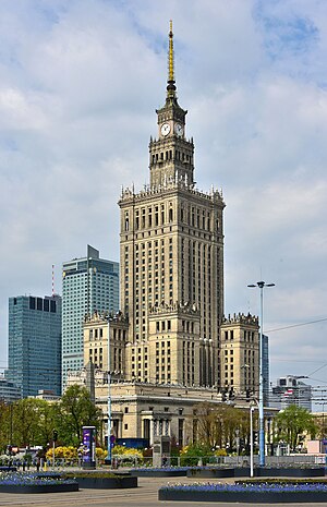
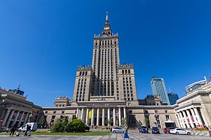
Palace of Culture and Science
High-rise building in Warsaw, Poland
Distance: Approx. 216 meters
Latitude and longitude: 52.23166667,21.00638889
The Palace of Culture and Science (Polish: Pałac Kultury i Nauki; abbreviated PKiN) is a notable high-rise building in central Warsaw, Poland. With a total height of 237 metres (778 ft), it is the second tallest building in both Warsaw and Poland (after the Varso Tower), the sixth tallest building in the European Union and one of the tallest on the European continent. At the time of its completion in 1955, the Palace was the eighth tallest building in the world, retaining the position until 1961; it was also briefly the tallest clock tower in the world, from 2000 until the 2002 installation of a clock mechanism on the NTT Docomo Yoyogi Building in Tokyo, Japan.

Warsaw Uprising
Major World War II operation by the Polish resistance Home Army
Distance: Approx. 193 meters
Latitude and longitude: 52.23,21.01083333
The Warsaw Uprising (Polish: powstanie warszawskie; German: Warschauer Aufstand), sometimes referred to as the August Uprising (Polish: powstanie sierpniowe), was a major World War II operation by the Polish underground resistance to liberate Warsaw from German occupation. It occurred in the summer of 1944, and it was led by the Polish resistance Home Army (Polish: Armia Krajowa). The uprising was timed to coincide with the retreat of the German forces from Poland ahead of the Soviet advance.
Warsaw Uprising (1794)
Armed uprising by Polish forces against the Russian garrison of Warsaw in 1794
Distance: Approx. 193 meters
Latitude and longitude: 52.23,21.01083333
The Warsaw Uprising of 1794 or Warsaw Insurrection (Polish: insurekcja warszawska) was an armed insurrection by the people of Warsaw early in the Kościuszko Uprising. Supported by the Polish Army, the uprising aimed to throw off control by the Russian Empire of the Polish capital city (Warsaw). It began on 17 April 1794, soon after Tadeusz Kościuszko's victory at the Battle of Racławice.

Collegium Civitas
Private university in Warsaw, Poland
Distance: Approx. 216 meters
Latitude and longitude: 52.231667,21.006389
Collegium Civitas is one of Poland's leading non-public higher education institutions, as reflected in the Perspektywy Ranking. It is a member of the Conference of Rectors of Academic Schools in Poland (CRASP) and the ConCollegium Civitas is one of Poland's leading non-public higher education institutions. It is a member of the Conference of Rectors of Academic Schools in Poland (CRASP) and the Conference of Rectors of Non-Public Academic Universities (KRAUN).

Warszawa Śródmieście railway station
Railway station in Warsaw, Poland
Distance: Approx. 64 meters
Latitude and longitude: 52.229444,21.007778
Warszawa Śródmieście railway station (Polish pronunciation: [ɕrudˈmjɛɕt͡ɕɛ]) is a railway station in Warsaw, Poland, in the district of Śródmieście. The station serves the suburban (southern) tracks of the Warsaw Cross-City Line and is used by regional trains run by Koleje Mazowieckie (KM) and Szybka Kolej Miejska (SKM). There are two side platforms and one island platform serving two tracks, all located in a tunnel.

Museum of Evolution of Polish Academy of Sciences
Science Museum in Warsaw, Poland
Distance: Approx. 216 meters
Latitude and longitude: 52.23166667,21.00638889
The Museum of Evolution of Polish Academy of Sciences (Polish: Muzeum Ewolucji Instytutu Paleobiologii Polskiej Akademii Nauk) is the display area of the natural history museum in Warsaw, Poland. It is the public front of the Muzeum i Instytut Zoologii or Zoology Museum and the Instytut Paleobiologii or Paleobiology Institute. It is based at the Palace of Culture and Science.

Museum of Communism, Warsaw
Distance: Approx. 218 meters
Latitude and longitude: 52.2317,21.0064
The Museum of Communism was a planned museum focusing on the communist period of Polish history, located in the Palace of Culture and Science in Warsaw. The idea for the museum emerged in 1999 by Czeslaw Bielecki, Jacek Fedorowicz, and Andrzej Wajda, with the cooperation of Teresa Bogucka, Anna Fedorowicz, and Krystyna Zachwatowicz. Currently, its implementation is interrupted.

Museum of Technology, Warsaw
Science museum in Warsaw, Poland
Distance: Approx. 216 meters
Latitude and longitude: 52.23166667,21.00638889
Muzeum Techniki w Warszawie is a museum in Warsaw, Poland. It was established in 1955. It is located in the Palace of Culture & Science.

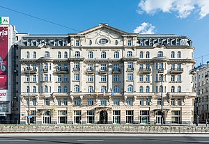
Hotel Polonia Palace
Distance: Approx. 193 meters
Latitude and longitude: 52.22941667,21.01066667
The Polonia Palace Hotel is a historic four-star hotel opened in 1913 and located in the heart of Warsaw on Jerusalem Avenue. It is the capital’s second oldest hotel after the Hotel Bristol, Warsaw. Together with the adjacent Metropol Hotel and the MDM Hotel, it is managed by the Syrena Hotel Group.
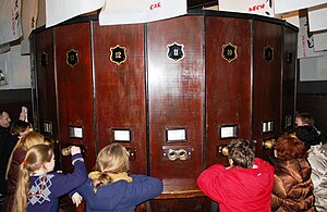
Warsaw Fotoplastikon
Distance: Approx. 138 meters
Latitude and longitude: 52.2288,21.0085
The Warsaw Fotoplastikon is a stereoscopic theatre based on the Kaiserpanorama system of rotating stereoscopic images located in Warsaw, Poland. Operating at the same location since 1946, it is the oldest stereoscopic theatre in Europe still in business at its original location. Today it operates as a branch of the Museum of the Warsaw Uprising.
Weather in this IP's area
broken clouds
4 Celsius
1 Celsius
3 Celsius
5 Celsius
1036 hPa
88 %
1036 hPa
1021 hPa
10000 meters
3.6 m/s
120 degree
75 %
06:44:38
15:54:54

