Country:
 Germany
Region:
City:
Latitude and Longitude:
Time Zone:
Postal Code:
IP information under different IP Channel
ip-api
Country
Region
City
ASN
Time Zone
ISP
Blacklist
Proxy
Latitude
Longitude
Postal
Route
IPinfo
Country
Region
City
ASN
Time Zone
ISP
Blacklist
Proxy
Latitude
Longitude
Postal
Route
MaxMind
Country
Region
City
ASN
Time Zone
ISP
Blacklist
Proxy
Latitude
Longitude
Postal
Route
Luminati
Country
 GB
GBASN
Time Zone
Europe/London
ISP
Talia Limited
Latitude
Longitude
Postal
db-ip
Country
Region
City
ASN
Time Zone
ISP
Blacklist
Proxy
Latitude
Longitude
Postal
Route
ipdata
Country
Region
City
ASN
Time Zone
ISP
Blacklist
Proxy
Latitude
Longitude
Postal
Route
Popular places and events near this IP address
Hameln-Pyrmont
District in Lower Saxony, Germany
Distance: Approx. 3454 meters
Latitude and longitude: 52.08,9.33
Hameln-Pyrmont is a district (Landkreis) in Lower Saxony, Germany. It is bounded by (from the north and clockwise) the districts of Schaumburg, Hanover, Hildesheim and Holzminden, and by the state of North Rhine-Westphalia (district of Lippe).

Hamelin
Town in Lower Saxony, Germany
Distance: Approx. 582 meters
Latitude and longitude: 52.1,9.36666667
Hamelin ( HAM-(ə-)lin; German: Hameln [ˈhaːml̩n] ) is a town on the river Weser in Lower Saxony, Germany. It is the capital of the district of Hamelin-Pyrmont and has a population of roughly 57,000. Hamelin is best known for the tale of the Pied Piper of Hamelin.
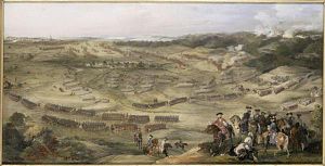
Battle of Hastenbeck
1757 battle
Distance: Approx. 480 meters
Latitude and longitude: 52.1,9.36
The Battle of Hastenbeck (26 July 1757) was fought as part of the Invasion of Hanover during the Seven Years' War between the allied forces of Hanover, Hesse-Kassel (or Hesse-Cassel) and Brunswick, and the French. The allies were defeated by the French army near Hamelin in the Electorate of Hanover.
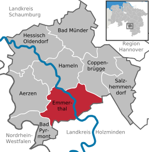
Emmerthal
Municipality in Lower Saxony, Germany
Distance: Approx. 6214 meters
Latitude and longitude: 52.05,9.38333333
Emmerthal is a municipality in the Hameln-Pyrmont district, in Lower Saxony, Germany. It is situated on the river Weser, approximatively 6 km south of Hameln. Its seat is in the village Kirchohsen.

Pied Piper's House
Medieval building in Hamelin, Germany
Distance: Approx. 62 meters
Latitude and longitude: 52.1042,9.3607
The Pied Piper's House or Rattenfängerhaus ("Rat Catcher's House") is a half-timbered building in Hamelin. It is named after an inscription on its side which purports to be an eyewitness account of the events of the Pied Piper of Hamelin story, describing the departure of the Hamelin children on 26 June 1284. An English translation given on a plaque reads: A.D. 1284 - on the 26th of June - the day of St.

Fischbeck Abbey
Distance: Approx. 6084 meters
Latitude and longitude: 52.14194444,9.29722222
Fischbeck Abbey (German: Stift Fischbeck) is a convent for canonesses in Fischbeck near Hessisch Oldendorf, Lower Saxony, Germany. It was founded in 955 by the noblewoman Helmburgis, a relation of the powerful family of the Ecbertiner, on land that had been given to her for the purpose by King Otto I, and is still a house of canonesses today, although now Lutheran women's convent rather than a Roman Catholic monastery. Despite later repairs and refurbishments, the cloisters and the church, built mostly in the 12th and 13th centuries, are still basically Romanesque.

Hamelin station
Railway station in Hamelin, Germany
Distance: Approx. 1024 meters
Latitude and longitude: 52.10194444,9.37611111
Hamelin station is a category 3 station in the town of Hamelin (German: Hameln) in the German state of Lower Saxony. It is situated on the Hanover–Altenbeken and the Elze–Löhne lines.

Hamel (river)
River in Germany
Distance: Approx. 980 meters
Latitude and longitude: 52.1092,9.3498
Hamel (in its lower course: Fluthamel) is a river of Lower Saxony, Germany. It flows into the Weser in Hameln.

Emmer (Weser)
River in Germany
Distance: Approx. 5446 meters
Latitude and longitude: 52.0568,9.3813
Emmer is a river of Lower Saxony and North Rhine-Westphalia, Germany. It flows into the Weser in Emmerthal.

Humme (Weser)
River in Germany
Distance: Approx. 1620 meters
Latitude and longitude: 52.0905,9.3536
Humme is a river of Lower Saxony, Germany. Its source is at the border of North Rhine-Westphalia. It flows into the Weser near Hameln.

Reich Harvest Thanksgiving Festival
Annual German festival 1933- 1937
Distance: Approx. 6146 meters
Latitude and longitude: 52.0547,9.4014
The Reich Harvest Thanksgiving Festival (German: Das Reichserntedankfest) was a monumental Nazi German celebration of the peasantry and the German farmers. The festivals ran from 1933 to 1937 on the Bückeberg, a hill near the town of Hamelin. Most festivals occurred every October, with the 1934 festival commencing 30 September.

Hamelin Prison
Historic site
Distance: Approx. 731 meters
Latitude and longitude: 52.10075,9.3525
Hamelin Prison, also known as the Stockhof, was a prison and penitentiary in Hamelin. The penal institution, which had a predecessor since 1698, existed from 1827 to 1980. It was located between the old town and the river Weser.
Weather in this IP's area
overcast clouds
18 Celsius
18 Celsius
16 Celsius
18 Celsius
1013 hPa
78 %
1013 hPa
1004 hPa
10000 meters
2.28 m/s
4.05 m/s
95 degree
100 %
07:52:57
18:22:01