Country:
 Canada
Region:
City:
Latitude and Longitude:
Time Zone:
Postal Code:
IP information under different IP Channel
ip-api
Country
Region
City
ASN
Time Zone
ISP
Blacklist
Proxy
Latitude
Longitude
Postal
Route
IPinfo
Country
Region
City
ASN
Time Zone
ISP
Blacklist
Proxy
Latitude
Longitude
Postal
Route
MaxMind
Country
Region
City
ASN
Time Zone
ISP
Blacklist
Proxy
Latitude
Longitude
Postal
Route
Luminati
Country
CARegion
qc
City
quebec
ASN
Time Zone
America/Toronto
ISP
LLC ott Ukraine
Latitude
Longitude
Postal
db-ip
Country
Region
City
ASN
Time Zone
ISP
Blacklist
Proxy
Latitude
Longitude
Postal
Route
ipdata
Country
Region
City
ASN
Time Zone
ISP
Blacklist
Proxy
Latitude
Longitude
Postal
Route
Popular places and events near this IP address

Beauport—Limoilou
Federal electoral district in Quebec, Canada
Distance: Approx. 2829 meters
Latitude and longitude: 46.842,-71.221
Beauport—Limoilou is a federal electoral district in Quebec City, Quebec, Canada, that has been represented in the House of Commons of Canada since 2004. The riding was created in 2003 as "Beauport" from parts of Beauport—Montmorency—Côte-de-Beaupré—Île-d'Orléans, Quebec and Quebec East ridings. It was renamed "Beauport—Limoilou" after the 2004 election.
Quebec County (federal electoral district)
Former federal electoral district in Quebec, Canada
Distance: Approx. 3608 meters
Latitude and longitude: 46.82,-71.21
Quebec County (French: Comté de Québec) was a federal electoral district in Quebec, Canada, that was represented in the House of Commons of Canada from 1867 to 1925. It was created by The British North America Act, 1867 which preserved existing ridings in Lower Canada. It was abolished in 1924 when it was merged into Québec—Montmorency riding.
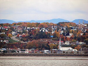
Beauport, Quebec City
Borough of Quebec City in Canada
Distance: Approx. 608 meters
Latitude and longitude: 46.852,-71.189
Beauport (French pronunciation: [bopɔʁ]) is a borough of Quebec City, Quebec, Canada on the Saint Lawrence River. Beauport is a northeastern suburb of Quebec City. Manufacturers include paint, construction materials, printers, and hospital supplies.

Cégep Limoilou
Public college in Quebec City, Quebec
Distance: Approx. 3826 meters
Latitude and longitude: 46.82999722,-71.22802222
Cégep Limoilou is a French-language CEGEP in the province of Quebec, situated in La Cité-Limoilou, a borough of Quebec City. Cégep Limoilou offers pre-university and technical programs, continuing education and corporate services. It has 6 faculties and 43 programs leading to a Diploma of College Studies (DEC) and 20 programs lead to an Attestation of College Studies (AEC).
Maizerets
Distance: Approx. 2368 meters
Latitude and longitude: 46.8375,-71.21222222
Maizerets is a neighbourhood of the la Cité-Limoilou borough of Quebec City, Quebec, Canada that had a population of 14 700 in 2011.
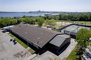
Aréna Marcel-Bédard
Multi-purpose arena in Quebec, Canada
Distance: Approx. 1187 meters
Latitude and longitude: 46.8575,-71.1897
The Arena Marcel Bedard is a multi-purpose arena in Beauport, Quebec. It has a capacity of 2,000 people. It hosted the Beauport Harfangs ice hockey team.

Davie Shipbuilding
Canadian shipbuilding company
Distance: Approx. 2720 meters
Latitude and longitude: 46.83015,-71.1594
Davie Shipbuilding is a shipbuilding company located in Lauzon, Quebec, Canada. The facility is now operating as Chantier Davie Canada Inc. and is the oldest continually operating shipbuilder in North America.

Saint-Charles River (Quebec City)
River in Quebec City in Canada
Distance: Approx. 2478 meters
Latitude and longitude: 46.826988,-71.197672
The Saint-Charles River (Huron-Wendat name is Akiawenrahk) is the main watercourse crossing Quebec City, Quebec, Canada. The surface of the Saint-Charles River (except the rapids areas) is generally frozen from the beginning of December to the end of March; however, safe circulation on the ice is generally done from the end of December to the beginning of March. The water level of the river varies with the seasons and the precipitation; the spring flood occurs in March or April.

Jean-Lesage
Provincial electoral district in Quebec, Canada
Distance: Approx. 2516 meters
Latitude and longitude: 46.84166667,-71.21666667
Jean-Lesage is a provincial electoral district in the Capitale-Nationale region of Quebec, Canada that elects members to the National Assembly of Quebec. It consists of parts of the Beauport and La Cité-Limoilou boroughs of Quebec City. It was created for the 2003 election from most of the former Limoilou and part of Montmorency electoral districts.

Marie-Josephte Corriveau
Woman from New France who murdered her second husband (1733–1763)
Distance: Approx. 3080 meters
Latitude and longitude: 46.82097222,-71.17272222
Marie-Josephte Corriveau (1733 at Saint-Vallier, Quebec – (1763-04-18)April 18, 1763 at Quebec City), better known as "la Corriveau", is a well-known figure in Québécois folklore. She lived in New France, and was sentenced to death by a British court martial for the murder of her second husband, was hanged for it and her body hanged in chains. Her story has become a legend in Quebec, and she is the subject of many books and plays.

Port of Quebec
Port in Canada
Distance: Approx. 3286 meters
Latitude and longitude: 46.821,-71.204
The Port of Quebec (French: Port de Québec) is an inland port located in Quebec City, Quebec, Canada. It is the oldest port in Canada, and the second largest in Quebec after the Port of Montreal.

Hôpital de l'Enfant-Jésus
Hospital in Quebec, Canada
Distance: Approx. 3360 meters
Latitude and longitude: 46.8375,-71.22638889
The Hôpital de l'Enfant-Jésus (English: Hospital of the Child Jesus) is a hospital located in Maizerets, a neighborhood of the district of La Cité-Limoilou in Quebec City, Quebec, Canada. It is one of only 3 hospitals in the province with a Level 1 Trauma Center.
Weather in this IP's area
broken clouds
10 Celsius
7 Celsius
9 Celsius
10 Celsius
1008 hPa
84 %
1008 hPa
1008 hPa
10000 meters
5.66 m/s
9.26 m/s
240 degree
75 %
06:14:08
19:10:44