Country:
 Mexico
Region:
City:
Latitude and Longitude:
Time Zone:
Postal Code:
IP information under different IP Channel
ip-api
Country
Region
City
ASN
Time Zone
ISP
Blacklist
Proxy
Latitude
Longitude
Postal
Route
IPinfo
Country
Region
City
ASN
Time Zone
ISP
Blacklist
Proxy
Latitude
Longitude
Postal
Route
MaxMind
Country
Region
City
ASN
Time Zone
ISP
Blacklist
Proxy
Latitude
Longitude
Postal
Route
Luminati
Country
MXRegion
cmx
City
mexicocity
ASN
Time Zone
America/Mexico_City
ISP
LLC ott Ukraine
Latitude
Longitude
Postal
db-ip
Country
Region
City
ASN
Time Zone
ISP
Blacklist
Proxy
Latitude
Longitude
Postal
Route
ipdata
Country
Region
City
ASN
Time Zone
ISP
Blacklist
Proxy
Latitude
Longitude
Postal
Route
Popular places and events near this IP address

Venustiano Carranza, Mexico City
Borough in Mexico City, Mexico
Distance: Approx. 697 meters
Latitude and longitude: 19.41666667,-99.11388889
Venustiano Carranza is a borough (demarcación territorial) in Mexico City, Mexico. Venustiano Carranza extends from the far eastern portion of the historic center of Mexico City eastward to the Peñón de los Baños and the border dividing the then Federal District from the State of Mexico. Historically, most of the territory was under Lake Texcoco, but over the colonial period into the 20th century, the lake dried up and today the area is completely urbanized.

Chamber of Deputies (Mexico)
Lower house of the legislature of Mexico
Distance: Approx. 1092 meters
Latitude and longitude: 19.43,-99.11777778
The Chamber of Deputies (Spanish: Cámara de Diputados, pronounced [ˈkamaɾa ðe ðipuˈtaðos]) is the lower house of the Congress of the Union, the bicameral parliament of Mexico. The other chamber is the Senate. The structure and responsibilities of both chambers of Congress are defined in Articles 50 to 70 of the constitution.

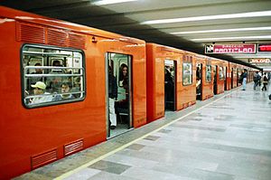
San Lázaro metro station
Mexico City metro station
Distance: Approx. 1199 meters
Latitude and longitude: 19.430213,-99.114833
San Lázaro is a station on the Mexico City Metro. It is located in the Venustiano Carranza borough of Mexico City. It lies along Lines 1 and B. The station was opened on 5 September 1969.

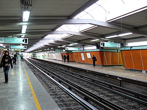
Candelaria metro station
Mexico City metro station
Distance: Approx. 951 meters
Latitude and longitude: 19.428837,-99.119511
Candelaria (Candelaria / Palacio Legislativo in some of the Line 4 signage) is a Mexico City Metro rail station. It is located in Venustiano Carranza municipality east of downtown Mexico City. It lies along Lines 1 and 4.
Merced metro station
Mexico City metro station
Distance: Approx. 810 meters
Latitude and longitude: 19.425558,-99.124639
Merced is an underground station on Line 1 of the Mexico City Metro. It is located in the Venustiano Carranza borough, slightly to the east of the centre of Mexico City. The station building was designed by Félix Candela, and it was opened on 4 September 1969.
Fray Servando metro station
Mexico City metro station
Distance: Approx. 197 meters
Latitude and longitude: 19.421633,-99.120541
Fray Servando is a metro station along Line 4 of the Mexico City Metro. It is located in the Venustiano Carranza borough of Mexico City.

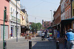
La Merced Market
Distance: Approx. 801 meters
Latitude and longitude: 19.42592222,-99.12405833
The La Merced Market is a traditional public market located in the eastern edge of the historic center of Mexico City and is the largest retail traditional food market in the entire city. The area, also called La Merced, has been synonymous with commercial activity since the early colonial period when traders arrived here from other parts of New Spain. At one time, nearly the entire neighborhood was filled with market stalls and in the 1860s it was decided to build a permanent market on the grounds of the old La Merced monastery.

Law enforcement in Mexico City
Mexico City Police
Distance: Approx. 543 meters
Latitude and longitude: 19.42513889,-99.11866667
Law enforcement in Mexico City is provided by two primary agencies; the Secretariat of Citizen Security of Mexico City (Secretaría de Seguridad ciudadana de la ciudad de México), who provides uniformed or preventative police, and the Office of the Attorney General of Mexico City (Fiscalía General de Justicia de la Ciudad de México) who provides plainclothes detectives and crime lab services.
Colonia Esperanza, Cuauhtémoc
Neighborhood in Mexico City
Distance: Approx. 966 meters
Latitude and longitude: 19.41976944,-99.12848056
Colonia Esperanza is a small colonia or neighborhood located in the Cuauhtémoc borough of Mexico City just southeast of the historic center. Its borders are defined by the following streets: Lorenzo Boturini to the south, Fray Servando Teresa de Mier to the north, Calzada de la Viga Canal to the east and Francisco Javier Clavijero to the west. Today it is an almostly completely residential neighborhood, but there is little known about its history.
Colonia Tránsito
Distance: Approx. 1056 meters
Latitude and longitude: 19.417625,-99.12895278
Colonia Tránsito is a colonia or neighborhood in the Cuauhtémoc borough of Mexico City, just south of the city's historic center. It is a residential area although there has been recent redevelopment for more commercial uses. It contains two colonial era churches (one in ruins), a number of buildings containing public offices and it is the home of soft drink maker Pascual Boing.

Mercado de Sonora
Market in the historic center of Mexico City
Distance: Approx. 604 meters
Latitude and longitude: 19.42220833,-99.12468333
Mercado de Sonora (Sonora Market) is a city-established traditional market, located just southeast of the historic center of Mexico City in the Colonia Merced Balbuena neighborhood. It was established in the 1950s with a number of other similar institutions in order to help regulate retail commerce in the city. This market has specialized in a variety of merchandise such as pottery, party items, and live animals — and the two which make it notable, herbal medicine and items related to magic and the occult.
La Merced (neighborhood)
Human settlement in Mexico
Distance: Approx. 963 meters
Latitude and longitude: 19.42673333,-99.12543333
La Merced is a barrio or a neighborhood of Mexico City defined by its socioeconomics and history rather than by an official designation. It extends over the southeast of the historic center of Mexico City and is one of the oldest sections of the city, established over 700 years ago by the Mexica as part of the founding of Tenochtitlan. Over its history the area was associated with commerce, first as a major docking area for boats bringing goods to Tenochtitlan/Mexico City on Lake Texcoco, later via canals as the lake was slowly drained.
Weather in this IP's area
light rain
14 Celsius
13 Celsius
13 Celsius
14 Celsius
1015 hPa
85 %
1015 hPa
783 hPa
10000 meters
4.12 m/s
340 degree
100 %
06:22:56
18:45:22