5.102.147.153 - IP Lookup: Free IP Address Lookup, Postal Code Lookup, IP Location Lookup, IP ASN, Public IP
Country:
 Switzerland
Region:
City:
Location:
Time Zone:
Postal Code:
ISP:
ASN:
language:
User-Agent:
Proxy IP:
Blacklist:
IP information under different IP Channel
ip-api
Country
Region
City
ASN
Time Zone
ISP
Blacklist
Proxy
Latitude
Longitude
Postal
Route
db-ip
Country
Region
City
ASN
Time Zone
ISP
Blacklist
Proxy
Latitude
Longitude
Postal
Route
IPinfo
Country
Region
City
ASN
Time Zone
ISP
Blacklist
Proxy
Latitude
Longitude
Postal
Route
IP2Location
5.102.147.153Country
chRegion
zurich
City
ruemlang / ruemlang (dorfkern)
Time Zone
Europe/Zurich
ISP
Language
User-Agent
Latitude
Longitude
Postal
ipdata
Country
Region
City
ASN
Time Zone
ISP
Blacklist
Proxy
Latitude
Longitude
Postal
Route
Popular places and events near this IP address
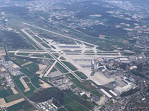
Zurich Airport
International airport serving Zürich, Switzerland
Distance: Approx. 2117 meters
Latitude and longitude: 47.46472222,8.54916667
Zurich Airport (IATA: ZRH, ICAO: LSZH) is the largest international airport of Switzerland and the principal hub of Swiss International Air Lines. It serves Zurich, the largest city in Switzerland, and, with its surface transport links, much of the rest of the country. The airport is located 13 kilometres (8 mi) north of central Zurich, in the municipalities of Kloten, Rümlang, Oberglatt, Winkel, and Opfikon, all of which are within the canton of Zurich.
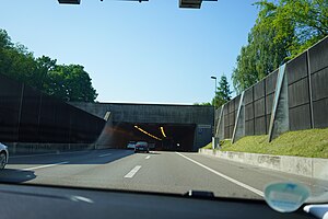
Bubenholz Tunnel
Road tunnel in Switzerland
Distance: Approx. 3429 meters
Latitude and longitude: 47.43305556,8.57111111
The Bubenholz Tunnel is a motorway tunnel in the Swiss canton of Zurich. It forms part of the A51 motorway, which links the A1 motorway with Zurich Airport. The tunnel is 550 metres (1,800 ft) long.

Opfikon
Municipality in Switzerland in Zürich
Distance: Approx. 3133 meters
Latitude and longitude: 47.43333333,8.56666667
Opfikon (German pronunciation: [ˈɔpfikoːn]; in the local Swiss German dialect: [ˈopfikxə]) is the name of a municipality in the Swiss canton of Zürich, located in the district of Bülach.

Rümlang
Municipality in Zurich, Switzerland
Distance: Approx. 92 meters
Latitude and longitude: 47.45,8.53333333
Rümlang is a municipality in the district of Dielsdorf in the canton of Zürich in Switzerland, and belongs to the Glatt Valley (German: Glattal). Zurich Airport is partially located in Rümlang.

District 11 (Zurich)
District in Zurich, Switzerland
Distance: Approx. 3064 meters
Latitude and longitude: 47.423,8.521
District 11 is the most northern and the most populous district in the Swiss city of Zurich. The district comprises the quarters Affoltern, Oerlikon and Seebach. All three were formerly municipalities in their own right, but were incorporated into Zurich in 1934.
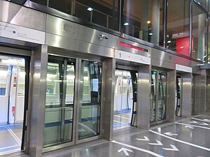
Skymetro
Zurich Airport gate transfer underground people mover
Distance: Approx. 2215 meters
Latitude and longitude: 47.456101,8.560201
The Zurich Airport Skymetro is an underground airport people mover at Zurich Airport in Switzerland. The 1.1 km (0.68 mi) long system connects the airport's main Airside Center, Gates A, B and D with its mid-field Gates E, passing underneath Runway 10/28. The line opened on 1 September 2003, and was constructed by the Otis Elevator Company.

Zurich Airport railway station
Railway station serving Zurich Airport in Switzerland
Distance: Approx. 2251 meters
Latitude and longitude: 47.45038194,8.56236694
Zurich Airport railway station (German: Bahnhof Zürich Flughafen) is a railway station serving Zurich Airport in Switzerland. The station is located underneath the Airport Centre, the main ground-side passenger terminal of the airport, which is in the canton of Zurich and the municipality of Kloten.
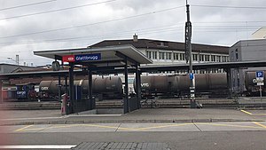
Glattbrugg railway station
Railway station in the Glattbrugg area of the Swiss municipality of Opfikon
Distance: Approx. 2869 meters
Latitude and longitude: 47.43080556,8.55888889
Glattbrugg railway station (German: Bahnhof Glattbrugg) is a railway station in Switzerland, in the Glattbrugg area of the municipality of Opfikon. The station is located on the main line of the Oerlikon–Bülach line and is an interchange point between the Zürich S-Bahn and the Stadtbahn Glattal light rail system. The station is served by S-Bahn lines S3, S9 and S15, and by Zürich tram routes 10 and 12, operating on behalf of the Stadtbahn Glattal.
Opfikon railway station
Railway station in Switzerland
Distance: Approx. 3089 meters
Latitude and longitude: 47.42995,8.56175806
Opfikon is a railway station in Switzerland, in the municipality of Opfikon. The station is served by Zürich S-Bahn line S7. Opfikon station is some 250 metres (820 ft) walk from Glattbrugg station on S-Bahn line S5 and the Stadtbahn Glattal.

Kloten Balsberg railway station
Railway station in Switzerland
Distance: Approx. 2997 meters
Latitude and longitude: 47.441985,8.570763
Kloten Balsberg is a railway station in the Swiss canton of Zürich and municipality of Kloten. The station is located on a variant of the multi-stranded Zürich–Winterthur railway line and is served by S-Bahn line S7. It is an interchange point between the Zürich S-Bahn and the Stadtbahn Glattal light rail system, which serves an elevated tram stop, adjacent to the station and connected directly to the station platform by an elevated walkway.

Oberglatt railway station
Railway station in Switzerland
Distance: Approx. 2843 meters
Latitude and longitude: 47.4702,8.51058694
Oberglatt railway station is a railway station in the Swiss canton of Zurich and municipality of Oberglatt. It is located at the junction of the standard gauge Oerlikon–Bülach and Wehntal lines of Swiss Federal Railways, and is served by Zürich S-Bahn lines S3, S9, and S15.

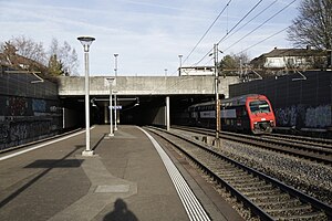
Rümlang railway station
Railway station in Zurich, Switzerland
Distance: Approx. 540 meters
Latitude and longitude: 47.45425,8.53276
Rümlang is a railway station in the Swiss canton of Zurich and municipality of Rümlang. It is served by Zurich S-Bahn lines S9 and S15.
Weather in this IP's area
mist
0 Celsius
-2 Celsius
-0 Celsius
1 Celsius
1039 hPa
91 %
1039 hPa
981 hPa
5000 meters
1.54 m/s
360 degree
75 %