5.101.71.142 - IP Lookup: Free IP Address Lookup, Postal Code Lookup, IP Location Lookup, IP ASN, Public IP
Country:
Region:
City:
Location:
Time Zone:
Postal Code:
IP information under different IP Channel
ip-api
Country
Region
City
ASN
Time Zone
ISP
Blacklist
Proxy
Latitude
Longitude
Postal
Route
Luminati
Country
ASN
Time Zone
Asia/Yerevan
ISP
edgeam LLC
Latitude
Longitude
Postal
IPinfo
Country
Region
City
ASN
Time Zone
ISP
Blacklist
Proxy
Latitude
Longitude
Postal
Route
IP2Location
5.101.71.142Country
Region
erevan
City
yerevan
Time Zone
Asia/Yerevan
ISP
Language
User-Agent
Latitude
Longitude
Postal
db-ip
Country
Region
City
ASN
Time Zone
ISP
Blacklist
Proxy
Latitude
Longitude
Postal
Route
ipdata
Country
Region
City
ASN
Time Zone
ISP
Blacklist
Proxy
Latitude
Longitude
Postal
Route
Popular places and events near this IP address

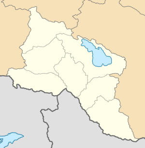
Erivan Governorate
Governorate of the Russian Empire
Distance: Approx. 285 meters
Latitude and longitude: 40.1833,44.5167
The Erivan Governorate was a province (guberniya) of the Caucasus Viceroyalty of the Russian Empire, with its centеr in Erivan (present-day Yerevan). Its area was 27,830 sq. kilometеrs, roughly corresponding to what is now most of central Armenia, the Iğdır Province of Turkey, and the Nakhchivan exclave of Azerbaijan.

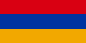
Armenia
Country in West Asia
Distance: Approx. 285 meters
Latitude and longitude: 40.18333333,44.51666667
Armenia, officially the Republic of Armenia, is a landlocked country in the Armenian Highlands of West Asia. It is a part of the Caucasus region and is bordered by Turkey to the west, Georgia to the north and Azerbaijan to the east, and Iran and the Azerbaijani exclave of Nakhchivan to the south. Yerevan is the capital, largest city and financial center.

National Gallery of Armenia
Art gallery in Yerevan, Armenia
Distance: Approx. 317 meters
Latitude and longitude: 40.17875,44.51416667
The National Gallery of Armenia (Armenian: Հայաստանի ազգային պատկերասրահ, Hayastani azgayin patkerasrah) is the largest art museum in Armenia. Located on Yerevan's Republic Square, the museum has one of the most prominent locations in the Armenian capital. The NGA houses significant collections of Russian and Western European art, and the world's largest collection of Armenian art.

Charents Museum of Literature and Arts
Literary museum and archive in Yerevan, Armenia
Distance: Approx. 303 meters
Latitude and longitude: 40.17888889,44.51444444
The Charents Museum of Literature and Arts (Armenian: Չարենցի անվան գրականության և արվեստի թանգարան, romanized: Charents'i anvan grakanut'yan yev arvesti t'angaran) is the largest repository of Armenian manuscripts and books encompassing the last three hundred years, located in Yerevan, Armenia.

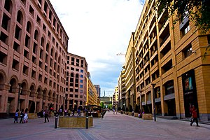
Northern Avenue, Yerevan
Street in Yerevan, Armenia
Distance: Approx. 82 meters
Latitude and longitude: 40.18222222,44.51472222
Northern Avenue (Armenian: Հյուսիսային պողոտա, romanized: Hyusisayin poghota) is a pedestrian avenue in Yerevan, Armenia, opened in 2007. It is in the central Kentron district and links Abovyan Street with Freedom Square on Tumanyan street. It is 450 metres (1,480 ft) long and 27 metres (89 ft) wide.

Saint Paul and Peter Church, Yerevan
Distance: Approx. 271 meters
Latitude and longitude: 40.181744,44.517383
Saint Paul and Peter Church (Armenian: Սուրբ Պողոս-Պետրոս Եկեղեցի; Surp Poghos-Petros yekeghetsi) was an Armenian Apostolic church in Yerevan, Armenia originally built during the 5th-6th centuries. It was demolished in November 1930 to make room for the Moscow Cinema on Abovyan Street.
Civilitas Foundation
Armenian non-profit organization
Distance: Approx. 249 meters
Latitude and longitude: 40.183701,44.515191
The Civilitas Foundation (Armenian: Սիվիլիթաս հիմնադրամ) is an Armenian non-profit organization based in Yerevan, and established in October 2008 by Armenia's former Minister of Foreign Affairs, Vartan Oskanian. It is a development agency and think tank currently directed by Apo Boghigian that works to strengthen civil society, promote democracy, economic development and education in Armenia, and facilitate dialogue between Armenia and the international community on a number of pertinent political issues. In doing so, Civilitas has strengthened the ties between Armenia and the Armenian Diaspora.

Erivan uezd
County of the Russian Empire
Distance: Approx. 31 meters
Latitude and longitude: 40.18138889,44.51444444
The Erivan uezd was a county (uezd) of the Erivan Governorate of the Caucasus Viceroyalty of the Russian Empire. The uezd bordered the Etchmiadzin and Surmalu uezds to the west, the Nor Bayazet uezd to the east, the Sharur-Daralayaz uezd to the south, and Iran to the southwest. It included most of the Ararat Province and southern parts of the Kotayk Province of central Armenia, the Sadarak District of the Nakhchivan exclave of Azerbaijan, and the Aras corridor of the Aralık District of the Iğdır Province of Turkey.
Stanislavski Russian Theatre of Yerevan
Distance: Approx. 213 meters
Latitude and longitude: 40.18194444,44.51666667
Officially State Russian Drama Theatre named after Konstantin Stanislavski (Armenian: Կոնստանտին Ստանիսլավսկու անվան ռուսական պետական դրամատիկական թատրոն), more commonly Stanislavski Russian Theatre, is a state theatre in the Armenian capital of Yerevan located on Abovyan Street in the central Kentron district of the city, next to Charles Aznavour Square. It was opened in 1937 and named after the Russian actor and theatre director Constantin Stanislavski since 1938. The theatre director is Alexander Grigoryan since 1965.

Capture of Erivan
Distance: Approx. 285 meters
Latitude and longitude: 40.18333333,44.51666667
The capture of Erivan (or Erevan/Yerevan; Persian: فتح ایروان, romanized: Fath e Iravān; Russian: Взятие Эривани, romanized: Vzyatie Ėrivani) took place on 1 October 1827, during the Russo-Persian War of 1826–28. The city fell to the Russians after being besieged for a week and opened up the path for the eventual capture of Tabriz, the second largest city in Iran and an important trading post.

Charles Aznavour Square, Yerevan
Square in Yerevan, Armenia
Distance: Approx. 256 meters
Latitude and longitude: 40.1818,44.5172
Charles Aznavour Square (in Armenian Շառլ Ազնավուրի հրապարակ) is a small square in the Kentron District of the Armenian capital Yerevan. The square is named in honour of the French Armenian singer Charles Aznavour as part of the celebrations of the 10th anniversary of Armenian independence in 2001. The square adjacent to Abovyan Street includes a number of important venues including Stanislavski Russian Theatre of Yerevan, the Moscow Cinema, the Artists' Union of Armenia offices.

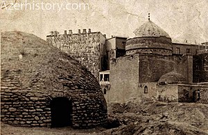
Zalkhan Mosque
Destroyed mosque in Armenia
Distance: Approx. 247 meters
Latitude and longitude: 40.181,44.517
Zalkhan Mosque (Armenian: Զալխանի մզկիթ) was a mosque in Yerevan, located in the Shahar quarter.
Weather in this IP's area
mist
-5 Celsius
-5 Celsius
-5 Celsius
-5 Celsius
1028 hPa
93 %
1028 hPa
900 hPa
2000 meters
20 %
