Country:
 _land Islands
Region:
City:
Latitude and Longitude:
Time Zone:
Postal Code:
IP information under different IP Channel
ip-api
Country
Region
City
ASN
Time Zone
ISP
Blacklist
Proxy
Latitude
Longitude
Postal
Route
IPinfo
Country
Region
City
ASN
Time Zone
ISP
Blacklist
Proxy
Latitude
Longitude
Postal
Route
MaxMind
Country
Region
City
ASN
Time Zone
ISP
Blacklist
Proxy
Latitude
Longitude
Postal
Route
Luminati
Country
 GB
GBASN
Time Zone
Europe/London
ISP
Tribeka Web Advisors S.A.
Latitude
Longitude
Postal
db-ip
Country
Region
City
ASN
Time Zone
ISP
Blacklist
Proxy
Latitude
Longitude
Postal
Route
ipdata
Country
Region
City
ASN
Time Zone
ISP
Blacklist
Proxy
Latitude
Longitude
Postal
Route
Popular places and events near this IP address

Mariehamn
Capital and the largest city of the Åland Islands
Distance: Approx. 333 meters
Latitude and longitude: 60.1,19.93333333
Mariehamn ( mə-REE-ə-hah-mən, Finland Swedish: [mɑriːeˈhɑmn] ; Finnish: Maarianhamina [ˈmɑːriɑnˌhɑminɑ]; Latin: Portus Mariae) is the capital of Åland, an autonomous territory under Finnish sovereignty. Mariehamn is the seat of the Government and Parliament of Åland, and 40% of the population of Åland live in the city. It is mostly surrounded by Jomala, the second-largest municipality in Åland in terms of population; to the east, it is bordered by Lemland.

Parliament of Åland
Elected body of autonomous area of Finland
Distance: Approx. 571 meters
Latitude and longitude: 60.0978,19.945
The Lagting, or Lagtinget, is the parliament of Åland, an autonomous, demilitarised and unilingually Swedish-speaking territory of Finland. The Lagting has 30 seats, which makes for approximately one seat per 700 voters in 2022.

Pommern (ship)
Iron-hulled sailing ship
Distance: Approx. 529 meters
Latitude and longitude: 60.09722222,19.92527778
Pommern, formerly Mneme (1903–1908), is an iron-hulled sailing ship. It is a four-masted barque that was built in 1903 at the J. Reid & Co shipyard in Glasgow, Scotland. Pommern (German for Pomerania) is one of the Flying P-Liners, the famous sailing ships of the German shipping company F. Laeisz.

Battle of Åland Islands
1915 naval battle between Germany and Russia during WW1
Distance: Approx. 2913 meters
Latitude and longitude: 60.1167,19.9
The Battle of Åland Islands, or the Battle of Gotland, which occurred in July 1915, was a naval battle of World War I between the German Empire and the Russian Empire, assisted by a submarine of the British Baltic Flotilla.

Wiklöf Holding Arena
Sports stadium in Åland, Finland
Distance: Approx. 571 meters
Latitude and longitude: 60.10222222,19.93527778
Wiklöf Holding Arena (located in Idrottsparken) is a multi-purpose stadium in Mariehamn, Finland. It is used mostly for football matches and is the home ground of IFK Mariehamn and Åland United. The stadium has a capacity of 1,635 seats, with standing places increasing the total capacity up to 4,500.
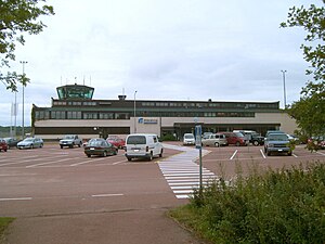
Mariehamn Airport
Airport in Åland, Finland
Distance: Approx. 3491 meters
Latitude and longitude: 60.12194444,19.89638889
Mariehamn Airport (Swedish: Mariehamns flygplats, Finnish: Maarianhaminan lentoasema, (IATA: MHQ, ICAO: EFMA) is located in Jomala, Åland (a territory of Finland). The airport is located some 3 kilometres (2 mi) north-west of Mariehamn town centre. It served 61,568 passengers in 2017 and is operated by the state-owned Finavia.
Ålandsparken
Former amusement park in Mariehamn, Åland
Distance: Approx. 706 meters
Latitude and longitude: 60.0909,19.9321
Ålandsparken was an amusement park located in Mariehamn in Åland, Finland. The park was relatively small, because Åland is a small area, both geographically and in terms of population number and density. The native population is probably too small to support a permanent amusement park, but Ålandsparken was located near Silja Line and Viking Line terminals, so it attracted tourists coming from the mainland of Finland and Sweden.
Åland University of Applied Sciences
Distance: Approx. 759 meters
Latitude and longitude: 60.1033,19.9291
Åland University of Applied Sciences (Swedish: Högskolan på Åland, HÅ) is a university of applied sciences (a polytechnic) in Mariehamn, Åland. It is housed in three different buildings, the North building (Neptunigatan 17), the Western Building (Neptunigatan 6) and the South Building (Navigationsskolegränd 2). It has approx.
Åland24
Distance: Approx. 2360 meters
Latitude and longitude: 60.1183,19.9344
Åland24 is a privately owned local television channel broadcasting mainly online and in the urban areas of Åland, an autonomous province of Finland. Åland24 began its operations during the fall of 2007, with its first broadcast occurring in October that year. The largest owner is Nya Ålands Tidningsaktiebolag.

Aero Flight 217
1963 aviation accident
Distance: Approx. 3491 meters
Latitude and longitude: 60.12194444,19.89638889
Aero Flight 217 was a domestic passenger flight from Helsinki, Finland, to Mariehamn in the autonomous territory of Åland, operated by the Finnish flag carrier Aero O/Y (now Finnair). On 8 November 1963, the aircraft serving the flight crashed in poor visibility while attempting to land on a non-precision approach at Mariehamn Airport in the municipality of Jomala, resulting in the deaths of 22 people out of 25 on board. The crash remains the second most deadly aviation accident in Finland, the first being Aero Flight 311 almost two years earlier.

F.P. von Knorring (ship)
Distance: Approx. 749 meters
Latitude and longitude: 60.0988,19.94786667
F.P. von Knorring (originally Jan Nieveen) is a passenger ship which was built in 1928 in the Netherlands and has been in continuous use. The ship has been a floating restaurant since 1989. It is docked in Mariehamn, capital of the Finnish province of Åland.

Western Harbour (Mariehamn)
Port in Finland
Distance: Approx. 616 meters
Latitude and longitude: 60.093056,19.927222
The Western Harbour (Swedish: Västerhamn) is one of two harbours in the port of Mariehamn, the regional capital of Åland, in the Archipelago Sea part of the Baltic.
Weather in this IP's area
broken clouds
7 Celsius
4 Celsius
7 Celsius
7 Celsius
1015 hPa
70 %
1015 hPa
1013 hPa
10000 meters
3.6 m/s
330 degree
75 %
08:20:13
18:31:23