Country:
Region:
City:
Latitude and Longitude:
Time Zone:
Postal Code:
IP information under different IP Channel
ip-api
Country
Region
City
ASN
Time Zone
ISP
Blacklist
Proxy
Latitude
Longitude
Postal
Route
Luminati
Country
Region
ge
City
geneva
ASN
Time Zone
Europe/Zurich
ISP
AlpineDC SA
Latitude
Longitude
Postal
IPinfo
Country
Region
City
ASN
Time Zone
ISP
Blacklist
Proxy
Latitude
Longitude
Postal
Route
db-ip
Country
Region
City
ASN
Time Zone
ISP
Blacklist
Proxy
Latitude
Longitude
Postal
Route
ipdata
Country
Region
City
ASN
Time Zone
ISP
Blacklist
Proxy
Latitude
Longitude
Postal
Route
Popular places and events near this IP address

Jet d'Eau
Fountain in Geneva, Switzerland
Distance: Approx. 395 meters
Latitude and longitude: 46.20722222,6.15611111
The Jet d'Eau (French pronunciation: [ʒɛ do], Water-Jet) is a large fountain in Geneva, Switzerland and is one of the city's most famous landmarks, being featured on the city's official tourism web site and on the official logo for Geneva's hosting of group stage matches at UEFA Euro 2008. Situated where Lake Geneva exits as the Rhône, it is visible throughout the city and from the air, even when flying over Geneva at an altitude of ten kilometres (33,000 ft). Five hundred litres (130 US gal) of water per second are jetted to an altitude of 140 metres (460 ft) by two 500 kW pumps, operating at 2,400 V, consuming one megawatt of electricity and costing 510,000 CHF per year.

Paddle steamer Genève
Steam ship
Distance: Approx. 350 meters
Latitude and longitude: 46.204838,6.154291
MS Genève is the oldest paddle ship of Lake Geneva. Originally a steamship, she became diesel powered in the 1930s. Genève was built in 1896 by Sulzer for the Compagnie Générale de Navigation sur le lac Léman (CGN).

Pierres du Niton
Distance: Approx. 310 meters
Latitude and longitude: 46.20555556,6.15444444
The Pierres du Niton (French for Neptune's Stones) are two glacial erratics in Lake Geneva, Switzerland, in Geneva harbor. On the left bank of the lake near Quai Gustave-Ador, they are remnants from the last ice age, left by the Rhone glacier. Because of their role in Swiss cartography, the rocks have been declared a "Geotope", a national site of geological heritage.

Jardin Anglais
Distance: Approx. 343 meters
Latitude and longitude: 46.204,6.152
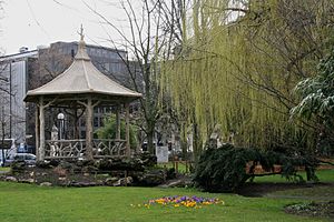
The Jardin anglais (literally "English garden") is an urban park in Geneva, Switzerland, situated at the location of an ancient harbor and a wood. It marks the beginning of the Quai Gustave-Ador. The park was created in 1855.

L'horloge fleurie
Distance: Approx. 313 meters
Latitude and longitude: 46.204192,6.15097
L'horloge fleurie, or the flower clock, is an outdoor flower clock located on the western side of Jardin Anglais park in Geneva, Switzerland. Around 6,500 flowering plants and shrubs are used for the clock face. The plants are changed as the seasons change.

Brunswick Monument
Mausoleum in Geneva, Switzerland
Distance: Approx. 215 meters
Latitude and longitude: 46.20845833,6.14916667
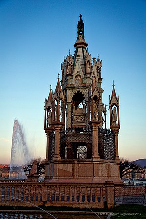
The Brunswick Monument is a mausoleum built in 1879 in the Jardin des Alpes in Geneva, Switzerland to commemorate the life of Charles II, Duke of Brunswick (1804–1873). He bequeathed his fortune to the city of Geneva in exchange for a monument to be built in his name, specifying that it be a replica of the Scaliger Tombs in Verona, Italy. The Grand Théâtre de Genève, opened in 1879, was built with the legacy.
Île Rousseau
Distance: Approx. 287 meters
Latitude and longitude: 46.20611111,6.1475
The Île Rousseau is an island and park in Geneva, situated in the middle of the Rhone. It was named after the philosopher Jean-Jacques Rousseau. On the island is a statue of Rousseau.
Permanent Representative of Andorra to the United Nations Office at Geneva
Distance: Approx. 439 meters
Latitude and longitude: 46.207923,6.145461
The Andorran Permanent Representative to the United Nations Office at Geneva has his residence in Andorra La Vella and is also accredited as Observer to the World Trade Organization.
Holy Trinity Church, Geneva
Anglican Church in Geneva, Switzerland
Distance: Approx. 374 meters
Latitude and longitude: 46.208056,6.146389
Holy Trinity Church, Geneva, Switzerland, was completed in 1853. The church is located at rue du Mont-Blanc, between the Genève-Cornavin railway station and the famous hotels at the banks of Lake Geneva. The church is part of the Diocese in Europe of the Church of England and is also a Swiss monument of regional significance (class B).

Emmanuel Episcopal Church (Geneva)
Church in Switzerland
Distance: Approx. 328 meters
Latitude and longitude: 46.20984722,6.14991944
Emmanuel Episcopal Church, located in Geneva, Switzerland, is an English speaking Episcopal parish of the Convocation of Episcopal Churches in Europe, and a member of the Anglican Communion. The church has previously been known as "The American Church" (and informally as "The American Chapel"), but this designation was abandoned in 1977 in the light of the decreasing American participation in the congregation. In December 1924 the church was established as a charitable foundation under Swiss law: La Fondation de la Chappelle d'Emmanuel.

Cité-centre
Place in Geneva, Switzerland
Distance: Approx. 476 meters
Latitude and longitude: 46.20277778,6.15
Cité-centre is an administrative term for the city center of Geneva, Switzerland.

Pont du Mont-Blanc
Distance: Approx. 215 meters
Latitude and longitude: 46.2059,6.1487
The Pont du Mont-Blanc, sometimes anglicized as Mont Blanc Bridge, is a major bridge in Geneva. It connect the quarters of the left banks of the Rhône to those of the right banks. It is a major north–south road axis in the Canton of Geneva, since its inauguration in 1862.
Weather in this IP's area
moderate rain
9 Celsius
7 Celsius
9 Celsius
10 Celsius
1008 hPa
87 %
1008 hPa
963 hPa
10000 meters
5.14 m/s
240 degree
75 %
07:42:32
16:59:30

