Country:
Region:
City:
Latitude and Longitude:
Time Zone:
Postal Code:
IP information under different IP Channel
ip-api
Country
Region
City
ASN
Time Zone
ISP
Blacklist
Proxy
Latitude
Longitude
Postal
Route
Luminati
Country
ASN
Time Zone
Asia/Bangkok
ISP
SBN-IIGAWN-IIG transit provider
Latitude
Longitude
Postal
IPinfo
Country
Region
City
ASN
Time Zone
ISP
Blacklist
Proxy
Latitude
Longitude
Postal
Route
db-ip
Country
Region
City
ASN
Time Zone
ISP
Blacklist
Proxy
Latitude
Longitude
Postal
Route
ipdata
Country
Region
City
ASN
Time Zone
ISP
Blacklist
Proxy
Latitude
Longitude
Postal
Route
Popular places and events near this IP address

Victory Monument (Bangkok)
Military monument in Bangkok, Thailand
Distance: Approx. 426 meters
Latitude and longitude: 13.76472222,100.53861111
Victory Monument (Thai: อนุสาวรีย์ชัยสมรภูมิ, RTGS: Anusawari Chai Samoraphum) is a military monument in Bangkok, Thailand. The monument was erected in June 1941 to commemorate the Thai victory in the Franco-Thai War. The monument is in Ratchathewi District, northeast of central Bangkok, at the center of a traffic circle at the intersection of Phahonyothin, Phaya Thai, and Ratchawithi roads.

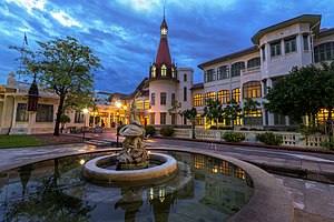
Phaya Thai Palace
Former royal residence in Bangkok
Distance: Approx. 781 meters
Latitude and longitude: 13.76833333,100.53277778
The Phya Thai Palace (Thai: วังพญาไท Wang Phaya Thai) or Royal Phya Thai Palace (พระราชวังพญาไท Phra Ratcha Wang Phaya Thai) is on the banks of the Samsen Canal (คลองสามเสน Khlong Sam Sen) on Rajavithee Road (ถนนราชวิถี Thanon Ratchawithi) in the Ratchathewi District of Bangkok. King Rama V bestowed on it the royal name of the Royal Residence of the Phya Thai (พระตำหนักพญาไท Phra Tamnak Phaya Thai) or the Phya Thai Palace, with Phya Thai (พญาไท Phaya Thai) meaning "lord of the Thais", during his reign and so it was built with this bearing on design.
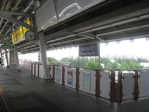
Sanam Pao BTS station
Railway station in Bangkok, Thailand
Distance: Approx. 532 meters
Latitude and longitude: 13.77262222,100.54209167
Sanam Pao station (Thai: สถานีสนามเป้า, pronounced [sā.tʰǎː.nīː sā.nǎːm pâw]) is a BTS skytrain station, on the Sukhumvit Line in Phaya Thai District, Bangkok, Thailand. The station is on Phahon Yothin Road near Soi Phahon Yothin 3 in Sanam Pao area, among office towers, an army base, and the site of Royal Thai Army Radio and Television Channel 5.

Victory Monument BTS station
Railway station in Bangkok, Thailand
Distance: Approx. 694 meters
Latitude and longitude: 13.76274444,100.53708694
Victory Monument station (Thai: สถานีอนุสาวรีย์ชัยสมรภูมิ; RTGS: Sathani Anusaowari Chai Samoraphum) is a BTS skytrain station, on the Sukhumvit Line in Ratchathewi District, Bangkok, Thailand. The station is located on Phaya Thai Road to the south of the Victory Monument, one of the landmark and major traffic intersection of Bangkok. The station is linked to all four corners of the traffic circle by a skybridge which almost traverses around the monument.

Santiphap Park
Park in Bangkok, Thailand
Distance: Approx. 595 meters
Latitude and longitude: 13.763151,100.541489
Santiphap Park (Thai: สวนสันติภาพ, RTGS: Suan Santiphap, literally "Peace Park") is an 8-acre (0.032 km2) park in Bangkok, Thailand. It is located between Ratchawithi Road and Rang Nam Road in Ratchathewi district. The land on which Santiphap Park is built is leased from the Crown Property Bureau by the Bangkok Metropolitan Administration (BMA).
Armed Forces Research Institute of Medical Sciences
United States Army collaboration with the Thai Government to fight the Bangkok Cholera Outbreak
Distance: Approx. 513 meters
Latitude and longitude: 13.76656,100.53561
The Armed Forces Research Institute of Medical Sciences (AFRIMS) (Thai: สถาบันวิจัยวิทยาศาสตร์การแพทย์ทหาร) is a United States Army project that started as a collaboration with the Government of Thailand to fight a cholera outbreak in Bangkok in 1958 and 1959. It subsequently expanded to conduct military medical research, primarily involving infectious diseases, across much of Southeast Asia and the Indian Subcontinent.

Phramongkutklao Hospital
Hospital in Bangkok, Thailand
Distance: Approx. 637 meters
Latitude and longitude: 13.767407,100.534178
Phramongkutklao Hospital (Thai: โรงพยาบาลพระมงกุฎเกล้า) is a hospital located in Ratchathewi District, Bangkok, Thailand. It is a military hospital for the Royal Thai Army and a teaching hospital for Phramongkutklao College of Medicine which trains doctors for the Royal Thai Armed Forces, as well as the Royal Thai Army Nursing College.
Sam Liam Din Daeng
Distance: Approx. 682 meters
Latitude and longitude: 13.76279167,100.54275556
Sam Liam Din Daeng or Din Daeng Junction (Thai: สามเหลี่ยมดินแดง, แยกดินแดง) is a road junction in the area of Thanon Phaya Thai Subdistrict, Ratchathewi District in downtown Bangkok. It is a three-way junction of Ratchawithi Road, Ratchaprarop Road and Din Daeng Road, being considered the beginning of the former two. The name of the junction refers to its triangular shape (sam liam, สามเหลี่ยม is Thai for triangle).
College of Medicine, Rangsit University
Medical school in Thailand
Distance: Approx. 679 meters
Latitude and longitude: 13.763033,100.536831
The College of Medicine, Rangsit University (Thai: วิทยาลัยแพทยศาสตร์ มหาวิทยาลัยรังสิต) is the first private medical school and the ninth oldest medical school in Thailand.

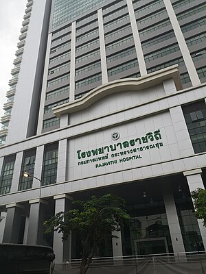
Rajavithi Hospital
Hospital in Bangkok, Thailand
Distance: Approx. 646 meters
Latitude and longitude: 13.76388889,100.53611111
Rajavithi Hospital (Thai: โรงพยาบาลราชวิถี) is large public hospital located in Ratchathewi District, Bangkok, Thailand. It was founded in 1951 as the Women's Hospital, and is operated by the Ministry of Public Health's Department of Medical Services. With an inpatient capacity of 1,200 beds, it is one of the largest hospitals in Thailand.
Queen Sirikit National Institute of Child Health
Hospital in Bangkok, Thailand
Distance: Approx. 573 meters
Latitude and longitude: 13.766079,100.535214
Queen Sirikit National Institute of Child Health (Thai: สถาบันสุขภาพเด็กแห่งชาติมหาราชินี) is large public hospital located in Ratchathewi District, Bangkok, Thailand. It serves as a teaching hospital for the College of Medicine, Rangsit University.
Hospital for Tropical Diseases (Thailand)
Hospital in Bangkok , Thailand
Distance: Approx. 712 meters
Latitude and longitude: 13.766444,100.533699
The Hospital for Tropical Diseases (Thai: โรงพยาบาลเวชศาสตร์เขตร้อน) is a hospital in Ratchathewi District, Bangkok. It is a public hospital operated by the Faculty of Tropical Medicine, Mahidol University. It specialises in tropical medicine and, since 2012, travel medicine.
Weather in this IP's area
few clouds
28 Celsius
31 Celsius
27 Celsius
28 Celsius
1008 hPa
74 %
1008 hPa
1007 hPa
9000 meters
2.57 m/s
340 degree
20 %
06:16:53
17:47:33
