Country:
 Hong Kong (China)
Region:
City:
Latitude and Longitude:
Time Zone:
Postal Code:
IP information under different IP Channel
ip-api
Country
Region
City
ASN
Time Zone
ISP
Blacklist
Proxy
Latitude
Longitude
Postal
Route
IPinfo
Country
Region
City
ASN
Time Zone
ISP
Blacklist
Proxy
Latitude
Longitude
Postal
Route
MaxMind
Country
Region
City
ASN
Time Zone
ISP
Blacklist
Proxy
Latitude
Longitude
Postal
Route
Luminati
Country
HKASN
Time Zone
Asia/Hong_Kong
ISP
Towngas Telecommunications Fixed Network Ltd
Latitude
Longitude
Postal
db-ip
Country
Region
City
ASN
Time Zone
ISP
Blacklist
Proxy
Latitude
Longitude
Postal
Route
ipdata
Country
Region
City
ASN
Time Zone
ISP
Blacklist
Proxy
Latitude
Longitude
Postal
Route
Popular places and events near this IP address
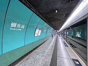
Quarry Bay station
MTR interchange station on Hong Kong Island
Distance: Approx. 392 meters
Latitude and longitude: 22.2878,114.2096
Quarry Bay (Chinese: 鰂魚涌; Cantonese Yale: Jāk'yùhchūng) is a station on the Island line and Tseung Kwan O line of the MTR in Quarry Bay on Hong Kong Island. The station livery is teal green.

Taikoo Place
Commercial building complex in Hong Kong
Distance: Approx. 626 meters
Latitude and longitude: 22.28577778,114.21113889
Taikoo Place (Chinese: 太古坊; Jyutping: taai3 gu2 fong1; pinyin: Tàigǔfāng) is a commercial building complex located in Quarry Bay, east Hong Kong Island, Hong Kong. It comprises grade A office towers, car parking, clubs, office apartment, parks, and shops. It is reachable by MTR Island line (MTR).

Braemar Hill
Hill on Hong Kong Island, Hong Kong
Distance: Approx. 656 meters
Latitude and longitude: 22.2864177,114.2064417
Braemar Hill (Chinese: 寶馬山; Jyutping: bou2 maa5 saan1; Cantonese Yale: bóumáhsān) is a hill with a height of 200 metres (660 ft) south of Braemar Point on Hong Kong Island, Hong Kong. The hill was likely named after the Scottish village of Braemar by British officials. Contrary to popular belief, the peak of Braemar Hill lies on the eastern end of Braemar Hill Road instead of the western end, where the ascent towards Red Incense Summit is noticeably steeper.

Tsat Tsz Mui Road
Road in Hong Kong
Distance: Approx. 524 meters
Latitude and longitude: 22.29143,114.20491
Tsat Tsz Mui Road (Chinese: 七姊妹道; pinyin: Qīzǐmèi Dào; Cantonese Yale: chat1 ji2 mui2 dou6; lit. 'Seven Sisters Road') is a road in Tsat Tsz Mui in Hong Kong. The road runs in the area of Tsat Tsz Mui and eastern North Point from west to east, parallel to King's Road, except disjoint by a residential-commercial complex of Island Place.

Tin Chiu Street
Distance: Approx. 702 meters
Latitude and longitude: 22.29139,114.203181
Tin Chiu Street (Chinese: 電照街) is a street in Tsat Tsz Mui of North Point in Hong Kong.
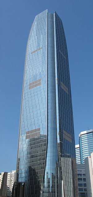
One Island East
Skyscraper in Quarry Bay, Hong Kong
Distance: Approx. 679 meters
Latitude and longitude: 22.28605556,114.21336111
One Island East is a skyscraper in Taikoo Place, Quarry Bay, Hong Kong Island, Hong Kong.
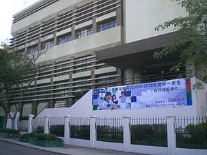
Pui Kiu Middle School
Secondary school
Distance: Approx. 679 meters
Latitude and longitude: 22.2878,114.2046
Pui Kiu Middle School (Chinese: 培僑中學) is a secondary school in Hong Kong. Located in the Eastern District area of North Point. The school uses Chinese language as a medium of instruction.

P&T Group
Architectural firm in Hong Kong
Distance: Approx. 354 meters
Latitude and longitude: 22.2922,114.2067
P&T Group (Chinese: 巴馬丹拿), formerly known as Palmer and Turner Hong Kong (Chinese: 公和洋行; "Kung Wo Yeung Hong"), is an architectural firm in Hong Kong. It is one of the oldest architecture and engineering firms in the world, and it has designed many landmark buildings in Hong Kong, Shanghai and in southeast Asia.

Healthy Village
Distance: Approx. 387 meters
Latitude and longitude: 22.29126,114.20624
Healthy Village is a public housing estate and Flat-for-Sale Scheme estate in Tsat Tsz Mui, Hong Kong, developed by the Hong Kong Housing Society. It is divided into 3 phases and located at Tsat Tsz Mui Road (Redeveloped Phase 1, flat for rental and sale), King's Road (Redeveloped Phase 2, flat for sale) and Pak Fuk Road (Redeveloped Phase 3, flat for rental) respectively. It consists of 14 residential blocks (4 for Phase 1, 3 for Phase 2, 7 for Phase 3) completed between 1965 and 1997.

Model Housing Estate
Housing estate in North Point, Hong Kong
Distance: Approx. 146 meters
Latitude and longitude: 22.29083,114.20868
Model Housing Estate is a public housing estate located at King's Road in Tsat Tsz Mui between Quarry Bay and North Point in Hong Kong, near MTR Quarry Bay station Exit C. It is the oldest existing public housing estate in Hong Kong. It comprises 7 residential blocks completed in 1954 and 1979 respectively, offering a total of 667 flats.

Quarry Bay Park
Urban park in Quarry Bay, Hong Kong
Distance: Approx. 798 meters
Latitude and longitude: 22.2889,114.2173
Quarry Bay Park (Chinese: 鰂魚涌公園) is an urban park located in the Quarry Bay area of Hong Kong Island's Eastern District. It lies between the waterfront and the Tai Koo Shing housing estate, and covers around 9.79 hectares (24.2 acres). The park is managed by the Leisure and Cultural Services Department of the Hong Kong Government.
Canossa College
Catholic, all-girls' school in Hong Kong
Distance: Approx. 264 meters
Latitude and longitude: 22.2892,114.2112
Canossa College (Chinese: 嘉諾撒書院) is a Catholic, all-girls' school, founded in 1959. Canossa College is funded by the Government as a subsidised school.
Weather in this IP's area
light rain
28 Celsius
32 Celsius
26 Celsius
28 Celsius
1008 hPa
86 %
1008 hPa
997 hPa
10000 meters
2.68 m/s
4.92 m/s
135 degree
100 %
06:08:08
18:33:57