Country:
 Spain
SpainRegion:
City:
Latitude and Longitude:
Time Zone:
Postal Code:
IP information under different IP Channel
ip-api
Country
Region
City
ASN
Time Zone
ISP
Blacklist
Proxy
Latitude
Longitude
Postal
Route
IPinfo
Country
Region
City
ASN
Time Zone
ISP
Blacklist
Proxy
Latitude
Longitude
Postal
Route
MaxMind
Country
Region
City
ASN
Time Zone
ISP
Blacklist
Proxy
Latitude
Longitude
Postal
Route
Luminati
Country
ESRegion
ar
City
biota
ASN
Time Zone
Europe/Madrid
ISP
Vodafone Spain
Latitude
Longitude
Postal
db-ip
Country
Region
City
ASN
Time Zone
ISP
Blacklist
Proxy
Latitude
Longitude
Postal
Route
ipdata
Country
Region
City
ASN
Time Zone
ISP
Blacklist
Proxy
Latitude
Longitude
Postal
Route
Popular places and events near this IP address
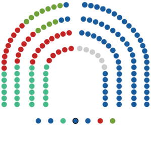
Assembly of Madrid
Distance: Approx. 2217 meters
Latitude and longitude: 40.38198611,-3.66230278
The Assembly of Madrid or Madrid Assembly (Spanish: Asamblea de Madrid) is the unicameral autonomous legislature of the Autonomous Community of Madrid since the approval of the Madrid Charter of Autonomy in 1983. It is elected every four years during the Spanish Regional and Municipal elections, as the Community of Madrid Charter of Autonomy does not recognise the right to call early elections (as in the Basque Country, Catalonia, Galicia and Andalusia), save for exceptional situations like the scandal that deadlocked the May 2003 Assembly and forced fresh elections in October 2003. According to the Charter, the Assembly is empowered to write Madrid's regional legislation, to control the regional government's actions, and to elect the President of the Community of Madrid.

Caja Mágica
Sports venue in Madrid, Spain
Distance: Approx. 1770 meters
Latitude and longitude: 40.368896,-3.684154
Caja Mágica (pronounced [ˈkaxa ˈmaxika]; Spanish for 'Magic Box'), also known as the Manzanares Park Tennis Center, is a multi-purpose stadium located in Madrid, Spain. Since 2009, it has been the home of the Madrid Open tennis tournament. There are three courts under the one structure, and a series of retractable roofs.
Madrid Open (tennis)
Tennis tournament
Distance: Approx. 1753 meters
Latitude and longitude: 40.3688,-3.684
The Madrid Open (Spanish: Masters de Madrid; formerly known as the Madrid Masters, and currently known as the Mutua Madrid Open for sponsorship reasons) is an annual professional tennis tournament held in Madrid, Spain. It is played on clay courts at the Caja Mágica in Manzanares Park, San Fermín, and is held in late April and early May. The tournament is an ATP Masters 1000 event on the ATP Tour and a WTA 1000 event on the WTA Tour.

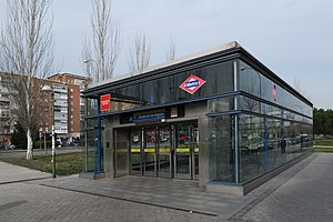
San Fermín-Orcasur (Madrid Metro)
Madrid Metro station
Distance: Approx. 2604 meters
Latitude and longitude: 40.3699938,-3.6941721
San Fermín-Orcasur [ˈsaɱ feɾˈmin oɾkaˈsuɾ] is a station on Line 3 of the Madrid Metro, serving the barrios of San Fermín and Orcasur.
Ciudad de los Ángeles (Madrid Metro)
Madrid Metro station
Distance: Approx. 2427 meters
Latitude and longitude: 40.3595825,-3.6936297
Ciudad de los Ángeles [θjuˈðað ðe los ˈaŋxeles] is a station on Line 3 of the Madrid Metro, serving the Los Ángeles barrio.

Villaverde Bajo-Cruce (Madrid Metro)
Madrid Metro station
Distance: Approx. 2644 meters
Latitude and longitude: 40.3508945,-3.6926458
Villaverde Bajo-Cruce ([biʝaˈβeɾðe ˈβaxo ˈkɾuθe], "Lower Villaverde–Crossroads") is a station on Line 3 of the Madrid Metro. It is located in fare Zone A. Its name refers to the intersection of the Avenida de Andalucía and the Carretera de Villaverde a Vallecas. It should not be confused with the homonymous station of Cercanías Madrid, as there is no direct access between the two stations.
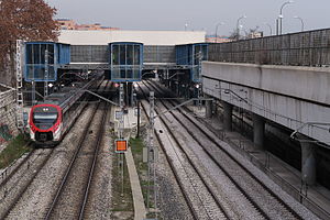
Villaverde Bajo railway station
Distance: Approx. 1916 meters
Latitude and longitude: 40.3525,-3.68388889
Villaverde Bajo, is a railway station serving the area of Villaverde in Madrid, Spain. Is owned by Adif and operated by Renfe Operadora. The station is served by Cercanías Madrid line C-3 and C-4.

San Fermín (Madrid)
Ward of Madrid, Spain
Distance: Approx. 2225 meters
Latitude and longitude: 40.37166667,-3.68833333
San Fermín is a ward (barrio) of Madrid belonging to the district of Usera.

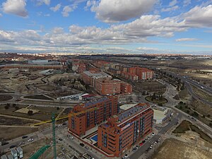
Palomeras Bajas
City neighborhood in Madrid, Community of Madrid, Spain
Distance: Approx. 2867 meters
Latitude and longitude: 40.38722222,-3.65722222
Palomeras Bajas is an administrative neighborhood (barrio) of Madrid belonging to the district of Puente de Vallecas. It has an area of 1.724430 km2 (0.665806 sq mi). As of 1 February 2020, it has a population of 41,034.
Butarque
Neighborhood of Madrid in Community of Madrid, Spain
Distance: Approx. 2407 meters
Latitude and longitude: 40.34361111,-3.67972222
Butarque is an administrative neighborhood (barrio) of Madrid belonging to the district of Villaverde.

Los Rosales (Madrid)
Ward of Madrid in Community of Madrid, Spain
Distance: Approx. 1737 meters
Latitude and longitude: 40.36027778,-3.68555556
Los Rosales is a ward (barrio) of Madrid belonging to the district of Villaverde.

Casco Histórico de Vallecas
Ward of Madrid in Spain
Distance: Approx. 2466 meters
Latitude and longitude: 40.35944444,-3.63638889
Casco Histórico de Vallecas is a ward (barrio) of Madrid belonging to the district of Villa de Vallecas.
Weather in this IP's area
few clouds
18 Celsius
18 Celsius
17 Celsius
19 Celsius
1012 hPa
83 %
1012 hPa
944 hPa
10000 meters
6.17 m/s
230 degree
20 %
08:16:12
19:48:54