46.8.206.134 - IP Lookup: Free IP Address Lookup, Postal Code Lookup, IP Location Lookup, IP ASN, Public IP
Country:
Region:
City:
Location:
Time Zone:
Postal Code:
IP information under different IP Channel
ip-api
Country
Region
City
ASN
Time Zone
ISP
Blacklist
Proxy
Latitude
Longitude
Postal
Route
Luminati
Country
ASN
Time Zone
Europe/Prague
ISP
Kaspersky Lab Switzerland GmbH
Latitude
Longitude
Postal
IPinfo
Country
Region
City
ASN
Time Zone
ISP
Blacklist
Proxy
Latitude
Longitude
Postal
Route
IP2Location
46.8.206.134Country
Region
bayern
City
ingolstadt
Time Zone
Europe/Berlin
ISP
Language
User-Agent
Latitude
Longitude
Postal
db-ip
Country
Region
City
ASN
Time Zone
ISP
Blacklist
Proxy
Latitude
Longitude
Postal
Route
ipdata
Country
Region
City
ASN
Time Zone
ISP
Blacklist
Proxy
Latitude
Longitude
Postal
Route
Popular places and events near this IP address

Ingolstadt
City in Bavaria, Germany
Distance: Approx. 244 meters
Latitude and longitude: 48.76305556,11.425
Ingolstadt (German: [ˈɪŋɡɔlˌʃtat] ; Austro-Bavarian: [ˈɪŋl̩ʃtɔːd]) is an independent city on the Danube, in Upper Bavaria, with 142,308 inhabitants (as of December 31, 2023). Around half a million people live in the metropolitan area. Ingolstadt is the second largest city in Upper Bavaria after Munich and the fifth largest city in Bavaria after Munich, Nuremberg, Augsburg and Regensburg.

Franz von Mercy
German general during the Thirty Years' War, fought for the Holy Roman Empire
Distance: Approx. 179 meters
Latitude and longitude: 48.76361111,11.42472222
Franz Freiherr von Mercy (or Merci), Lord of Mandre and Collenburg (c. 1597 – 3 August 1645), was a German field marshal in the Thirty Years' War who fought for the Imperial side and was commander-in-chief of the Bavarian army from 1643 to 1645. In that role, he destroyed a French army at Tuttlingen (1643), stalemated another at Freiburg (1644), destroyed a third French army at Herbsthausen (1645) and was killed at the Second Battle of Nördlingen (1645).
WFI – Ingolstadt School of Management
Distance: Approx. 572 meters
Latitude and longitude: 48.765,11.416
The WFI – Ingolstadt School of Management (or WFI Ingolstadt) is a leading German business school and the faculty of business administration and economics of the Catholic University of Eichstätt-Ingolstadt. The WFI (meaning "Wirtschaftswissenschaftliche Fakultät Ingolstadt" ) is one of Germany's foremost business schools and the modern successor of Bavaria's first university, i.e. the ancient University of Ingolstadt.

Ingolstadt Nord station
Railway station in Ingolstadt, Germany
Distance: Approx. 1105 meters
Latitude and longitude: 48.7732,11.4325
Ingolstadt Nord station (also called the Nordbahnhof in German, meaning "North station") is the second operational passenger station in the town of Ingolstadt, in the state of Bavaria in southern Germany. The other station is Ingolstadt Hauptbahnhof. The station is entered in the official list of Deutsche Bahn station abbreviations as MIN and is classified by Deutsche Bahn as a category 3 station.

Kreuztor (Ingolstadt)
Distance: Approx. 444 meters
Latitude and longitude: 48.764177,11.417917
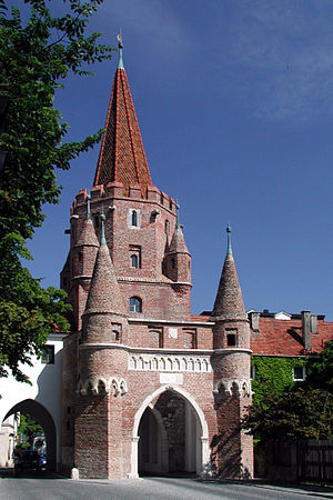
The Kreuztor, built in 1385, is the western gateway to the medieval city center of Ingolstadt. The tower's name is derived from the leper house belonging to the Church of the Holy Cross (Kirche zum heiligen Kreuz), which stood to the west of the city walls until its destruction in the Schmalkaldic War in 1546. This seven-turreted guard tower was part of Ingolstadt's second city wall.
Schutter (Danube)
River in Germany
Distance: Approx. 891 meters
Latitude and longitude: 48.7571,11.4242
Schutter is a river of Bavaria, Germany. It is a left tributary of the Danube in Ingolstadt.
Stadttheater Ingolstadt
Distance: Approx. 437 meters
Latitude and longitude: 48.76305556,11.42888889
Stadttheater Ingolstadt is a theatre in Bavaria, Germany.
New Castle (Ingolstadt)
Distance: Approx. 497 meters
Latitude and longitude: 48.76472222,11.43055556
The New Castle in Ingolstadt is one of the most important Gothic secular buildings of the 15th Century in Bavaria. The builders were Louis VII, Duke of Bavaria-Ingolstadt and Duke George the Rich of Bavaria-Landshut, both of the Wittelsbach dynasty. The neighboring Old Castle, a medieval fortress from the 13th Century, is today called Herzogkasten.
Jesuit College of Ingolstadt
Jesuit school in Germany
Distance: Approx. 219 meters
Latitude and longitude: 48.765278,11.420833
The Jesuit College of Ingolstadt (German: Jesuitenkolleg Ingolstadt) was a Jesuit school in Ingolstadt, in the Duchy and Electorate of Bavaria, founded in 1556, that operated until the suppression of the Jesuit Order in 1773. The college was the headquarters of the Jesuits in Germany, and became a center of the Counter-Reformation. Many of its members taught at the University of Ingolstadt.

Bayerisches Armeemuseum
Military history museum in Munich, Germany
Distance: Approx. 553 meters
Latitude and longitude: 48.76471,11.43131
The Bayerisches Armeemuseum is the Military History Museum of Bavaria. It was founded in 1879 in Munich and is located in Ingolstadt since 1972. The main collection is housed in the New Castle, the permanent exhibition about the First World War in Reduit Tilly opened in 1994 and the Armeemuseum incorporated the Bayerisches Polizeimuseum (Bavarian Police Museum) in the Turm Triva in 2012.
Bavarian Police Museum
Distance: Approx. 887 meters
Latitude and longitude: 48.76238889,11.43516111
The Bavarian Police Museum (Bayerische Polizeimuseum) is the central museum of the Bavarian State Police, housed in the historic Turm Triva in the Klenzepark in Ingolstadt. It opened on 19 December 2011. It includes a variety of exhibits dating from 1918 onwards and explains the history, organisation and development of policing in Bavaria since the 1918–19 Bavarian Revolution.

Technische Hochschule Ingolstadt
University in Bavaria, Germany
Distance: Approx. 707 meters
Latitude and longitude: 48.767,11.433
The Technical University Ingolstadt of Applied Sciences (Technische Hochschule Ingolstadt (THI)) is a German public university of applied sciences (Hochschule für angewandte Wissenschaften) located in Ingolstadt. Founded in 1994, it currently has around 6,500 students in five faculties and offers more than 80 courses of study. The central focus of research and teaching are in technology and business.
Weather in this IP's area
overcast clouds
-2 Celsius
-6 Celsius
-3 Celsius
-2 Celsius
1039 hPa
84 %
1039 hPa
991 hPa
50 meters
2.57 m/s
80 degree
100 %


