46.71.36.73 - IP Lookup: Free IP Address Lookup, Postal Code Lookup, IP Location Lookup, IP ASN, Public IP
Country:
 Armenia
Region:
City:
Location:
Time Zone:
Postal Code:
ISP:
ASN:
language:
User-Agent:
Proxy IP:
Blacklist:
IP information under different IP Channel
ip-api
Country
Region
City
ASN
Time Zone
ISP
Blacklist
Proxy
Latitude
Longitude
Postal
Route
db-ip
Country
Region
City
ASN
Time Zone
ISP
Blacklist
Proxy
Latitude
Longitude
Postal
Route
IPinfo
Country
Region
City
ASN
Time Zone
ISP
Blacklist
Proxy
Latitude
Longitude
Postal
Route
IP2Location
46.71.36.73Country
amRegion
lori
City
vanadzor
Time Zone
Asia/Yerevan
ISP
Language
User-Agent
Latitude
Longitude
Postal
ipdata
Country
Region
City
ASN
Time Zone
ISP
Blacklist
Proxy
Latitude
Longitude
Postal
Route
Popular places and events near this IP address
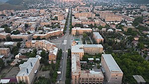
Vanadzor
City in Lori, Armenia
Distance: Approx. 1024 meters
Latitude and longitude: 40.81277778,44.48833333
Vanadzor (Armenian: Վանաձոր, IPA: [vɑnɑˈd͡zɔɾ]) is an urban municipal community and the third largest city in Armenia, serving as the capital of Lori Province in the northern part of the country. It is located about 128 kilometres (80 miles) north of the capital Yerevan. As of the 2011 census, the city had a population of 86,199, down from 148,876 reported at the 1979 official census.

Battle of Karakilisa
Battles involving Armenian National movement
Distance: Approx. 1030 meters
Latitude and longitude: 40.8,44.4833
The Battle of Karakilisa (Armenian: Ղարաքիլիսայի ճակատամարտ Gharakilisayi chakatamart, Turkish: Karakilise Muharebesi or Karakilise Muharebeleri) took place during the Caucasus Campaign of World War I in the vicinity of Karakilisa (now Vanadzor), on May 25–28, 1918.

Shahumyan, Lori
Place in Lori, Armenia
Distance: Approx. 3662 meters
Latitude and longitude: 40.78833333,44.53166667
Shahumyan (Armenian: Շահումյան) is a town in the Lori Province of Armenia.

Holy Children Chapel, Vanadzor
Distance: Approx. 2221 meters
Latitude and longitude: 40.785495,44.486301
Holy Children Chapel of Vanadzor is located at Tsitsernak Children's Camp of the Diocese of Gougark south to Vanadzor, Armenia.

Vanadzor City Stadium
Distance: Approx. 821 meters
Latitude and longitude: 40.79722222,44.49388889
Vanadzor City Stadium (Armenian: Վանաձորի քաղաքային մարզադաշտ), is a multi-use stadium in Vanadzor, Armenia, currently used for football matches. Opened in 1958 as Lori Stadium (Armenian: Լոռի մարզադաշտ) with a capacity of 5,000 spectators, it served as home to Lori Vanadzor and FC Vanadzor.

Tandzut (river)
River in Lori, Armenia
Distance: Approx. 1343 meters
Latitude and longitude: 40.816,44.4991
The Tandzut (Armenian: Տանձուտ, also Գարպի Garpi) is a river in Lori Province, Northern Armenia, a right tributary of the river Pambak (Kura basin). The source of the river is located on the Northern side of Pambak mountain range. The river is 23 kilometres (14 mi) long.
Vanadzor (river)
River in Armenia
Distance: Approx. 417 meters
Latitude and longitude: 40.8041,44.4988
Vanadzor (Armenian: Վանաձոր), is a river in Lori Province, Northern Armenia. It is 14 kilometres (8.7 mi) long, and discharges into the Tandzut (a tributary of the Pambak) in the town of Vanadzor.

Vanadzor State University
University in Armenia
Distance: Approx. 543 meters
Latitude and longitude: 40.80888889,44.49083333
Vanadzor State University named after Hovhannes Tumanyan (VSU) (Armenian: Վանաձորի Հովհաննես Թումանյանի անվան Պետական Համալսարան), is a public university in Vanadzor, Lori Province, Armenia. With 5 faculties, it is the largest university in the Lori Province. It provides degrees in Philology, History and Geography, Pedagogy, Biology and Chemistry, and Physics and Mathematics.

Church of the Holy Mother of God, Vanadzor
Distance: Approx. 1152 meters
Latitude and longitude: 40.81486111,44.49569444
Church of the Holy Mother of God (Armenian: Սուրբ Աստվածածին եկեղեցի), is a 19th-century church in Vanadzor, Armenia. It was constructed between 1828 and 1830 and consecrated in 1831. The construction was completed through the donation of Yuzbashi (captain) Piluman Tayiryants, during the reign of tsar Nicholas I of Russia and Catholicos John VIII of Armenia.

Hayk Square
Historic site in Vanadzor, Armenia
Distance: Approx. 1039 meters
Latitude and longitude: 40.81083333,44.48472222
Hayk Square (Armenian: Հայքի Հրապարակ Hayki Hraparak), is the large central town square in Vanadzor, Armenia. It is intersected by the Tigran Mets Avenue from the southeast the northwest, and the Movses Khorenatsi Street from the northeast. The square was opened during the 1950s, based on the original plan designed by architects Baghdasar Arzoumanian and Hovhannes Margarian.
Vanadzor Technology Center
Distance: Approx. 2458 meters
Latitude and longitude: 40.79722222,44.52138889
Vanadzor Technology Center (Armenian: Վանաձորի տեխնոլոգիական կենտրոն), is a technological center for IT development in Vanadzor, the third-largest city in Armenia. It was opened on 29 October 2016. Founded by the Enterprise Incubator Foundation with the support of Government of Armenia and the World Bank, the project aims to promote the business and technology environment in Lori Province and the entire region of north Armenia.

Vanadzor Fine Arts Museum
Museum in Armenia
Distance: Approx. 341 meters
Latitude and longitude: 40.80705,44.49633
The Vanadzor Fine Arts Museum (Armenian: ՎանաձորիԿերպարվեստի թանգարան) was founded in 1974 as a branch of the National Gallery of Armenia. Five years later, in 1979, museum authority transferred to the Kirovakan City Council (today's Vanadzor Community Council), and in 2004 it was included in the Republic of Armenia's Historical and Cultural Monuments of Lori marz (province).
Weather in this IP's area
overcast clouds
2 Celsius
0 Celsius
2 Celsius
2 Celsius
1018 hPa
65 %
1018 hPa
792 hPa
10000 meters
1.74 m/s
2.91 m/s
98 degree
100 %