46.71.27.172 - IP Lookup: Free IP Address Lookup, Postal Code Lookup, IP Location Lookup, IP ASN, Public IP
Country:
 Armenia
Region:
City:
Location:
Time Zone:
Postal Code:
ISP:
ASN:
language:
User-Agent:
Proxy IP:
Blacklist:
IP information under different IP Channel
ip-api
Country
Region
City
ASN
Time Zone
ISP
Blacklist
Proxy
Latitude
Longitude
Postal
Route
db-ip
Country
Region
City
ASN
Time Zone
ISP
Blacklist
Proxy
Latitude
Longitude
Postal
Route
IPinfo
Country
Region
City
ASN
Time Zone
ISP
Blacklist
Proxy
Latitude
Longitude
Postal
Route
IP2Location
46.71.27.172Country
amRegion
ararat
City
artashat
Time Zone
Asia/Yerevan
ISP
Language
User-Agent
Latitude
Longitude
Postal
ipdata
Country
Region
City
ASN
Time Zone
ISP
Blacklist
Proxy
Latitude
Longitude
Postal
Route
Popular places and events near this IP address
Artashat, Armenia
Place in Ararat, Armenia
Distance: Approx. 983 meters
Latitude and longitude: 39.95388889,44.55055556
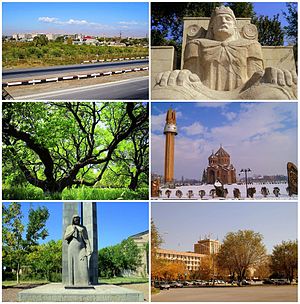
Artashat (Armenian: Արտաշատ [ɑɾtɑˈʃɑt]) is a town and administrative center of the Artashat Municipality and the Ararat Province of Armenia. It is located on the Azat River in the Ararat Plain, 30 km southeast of Yerevan. Artashat was originally a village called Ghamarlu, established by Armenian migrants from Iran in 1828–29.

Azatavan
Place in Ararat, Armenia
Distance: Approx. 4514 meters
Latitude and longitude: 39.98333333,44.5
Azatavan (Armenian: Ազատավան) is a village in the Artashat Municipality of the Ararat Province of Armenia.

Vostan
Place in Ararat, Armenia
Distance: Approx. 1282 meters
Latitude and longitude: 39.95888889,44.55916667
Vostan (Armenian: Ոստան) is a village in the Artashat Municipality of the Ararat Province of Armenia.

Baghramyan, Ararat
Place in Ararat, Armenia
Distance: Approx. 2731 meters
Latitude and longitude: 39.97666667,44.51944444
Baghramyan (Armenian: Բաղրամյան) is a village in the Artashat Municipality of the Ararat Province of Armenia. It is named after the Soviet Armenian military commander and Marshal of the Soviet Union Hovhannes Baghramyan.

Berkanush
Place in Ararat, Armenia
Distance: Approx. 3406 meters
Latitude and longitude: 39.98333333,44.51666667
Berkanush (Armenian: Բերքանուշ) is a village in the Artashat Municipality of the Ararat Province of Armenia.
Burastan
Place in Ararat, Armenia
Distance: Approx. 4514 meters
Latitude and longitude: 39.98333333,44.5
Burastan (Armenian: Բուրաստան) is a village in the Artashat Municipality of the Ararat Province of Armenia.
Berdik
Place in Ararat, Armenia
Distance: Approx. 4695 meters
Latitude and longitude: 40,44.56666667
Berdik (Armenian: Բերդիկ) is a village in the Artashat Municipality of the Ararat Province of Armenia.

Dalar, Armenia
Place in Ararat, Armenia
Distance: Approx. 927 meters
Latitude and longitude: 39.96694444,44.53638889
Dalar (Armenian: Դալար) is a village in the Artashat Municipality of the Ararat Province of Armenia.

Mrgavan
Place in Ararat, Armenia
Distance: Approx. 1088 meters
Latitude and longitude: 39.96611111,44.53333333
Mrgavan (Armenian: Մրգավան) is a village in the Artashat Municipality of the Ararat Province of Armenia.
Nerkin Kamarlu
Place in Ararat, Armenia
Distance: Approx. 1353 meters
Latitude and longitude: 39.95,44.55
Nerkin Kamarlu (also, Nerk’in Kamarlu) is a town in the Ararat Province of Armenia.

Shahumyan, Ararat
Place in Ararat, Armenia
Distance: Approx. 4463 meters
Latitude and longitude: 39.93083333,44.57833333
Shahumyan (Armenian: Շահումյան) is a village in the Artashat Municipality of the Ararat Province of Armenia. It is named after Stepan Shahumyan, a Bolshevik commissar.

Artashat City Stadium
Distance: Approx. 651 meters
Latitude and longitude: 39.95555556,44.54416667
Artashat City Stadium (Armenian: Արտաշատի քաղաքային մարզադաշտ) is a multipurpose stadium in Artashat, Armenia, mostly used for football matches as well as for domestic events of Athletics.
Weather in this IP's area
clear sky
-4 Celsius
-6 Celsius
-4 Celsius
-4 Celsius
1029 hPa
57 %
1029 hPa
917 hPa
10000 meters
1.36 m/s
1.62 m/s
290 degree
7 %