Country:
 Israel
Region:
City:
Latitude and Longitude:
Time Zone:
Postal Code:
IP information under different IP Channel
ip-api
Country
Region
City
ASN
Time Zone
ISP
Blacklist
Proxy
Latitude
Longitude
Postal
Route
IPinfo
Country
Region
City
ASN
Time Zone
ISP
Blacklist
Proxy
Latitude
Longitude
Postal
Route
MaxMind
Country
Region
City
ASN
Time Zone
ISP
Blacklist
Proxy
Latitude
Longitude
Postal
Route
Luminati
Country
 PS
PSASN
Time Zone
Asia/Hebron
ISP
AL Zaytona Company For Communication Ltd.
Latitude
Longitude
Postal
db-ip
Country
Region
City
ASN
Time Zone
ISP
Blacklist
Proxy
Latitude
Longitude
Postal
Route
ipdata
Country
Region
City
ASN
Time Zone
ISP
Blacklist
Proxy
Latitude
Longitude
Postal
Route
Popular places and events near this IP address

Ramallah
Palestinian city in the West Bank
Distance: Approx. 531 meters
Latitude and longitude: 31.9,35.2
Ramallah (UK: rə-MAL-ə, US: rə-MAH-lə; Arabic: رام الله, romanized: , lit. 'God's Height') is a Palestinian city in the central West Bank, that serves as the de facto administrative capital of the State of Palestine. It is situated on the Judaean Mountains, 10 km (6 miles) north of Jerusalem, at an average elevation of 872 meters (2,861 ft) above sea level, adjacent to al-Bireh. Ramallah has buildings containing masonry from the period of Herod the Great, but no complete building predates the Crusades of the 11th century.
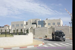
Mukataa
Arabic term for an administrative center
Distance: Approx. 1068 meters
Latitude and longitude: 31.91233333,35.20856389
Mukataa (Arabic: مقاطعة, romanized: muqāṭaʿah) is an Arabic word for headquarters or administrative center, particularly in Palestine. Mukataas were mostly built during the British Mandate as Tegart forts and were used both as British government centers and as dwellings for the British administrative staff. Some Mukataas also included police stations and prisons.

Khalil Sakakini Cultural Center
Cultural center in Ramallah, Palestine
Distance: Approx. 596 meters
Latitude and longitude: 31.898625,35.20179444
Khalil Sakakini Cultural Center (Arabic: مركز خليل السكاكيني الثقافي) is a leading Palestinian arts and culture organization that aims to create a pluralistic, critical liberating culture through research, query, and participation, and that provides an open space for the community to produce vibrant and liberating cultural content. Located in Ramallah, KSCC is housed in a renovated building, dating back to the early 20th century, based on traditional Palestinian architecture. Initially established in May 1996 as a branch of the Palestinian Ministry of Culture, KSCC was registered as a non-profit non-governmental organization (NGO) in 1998.
2000 Ramallah lynching
Lynching of two Israelis in the occupied West Bank
Distance: Approx. 164 meters
Latitude and longitude: 31.905,35.2044
The 2000 Ramallah lynching was a violent incident that took place at the el-Bireh police station, where a Palestinian crowd of passing funeral marchers broke in and killed and mutilated the bodies of two Israeli military reservists on 12 October 2000 during the Second Intifada. Vadim Nurzhitz and Yosef "Yossi" Avrahami had accidentally entered the Palestinian Authority-controlled city of Ramallah in the Israeli-occupied West Bank and were taken into custody by Palestinian Authority policemen, 13 of whom were injured while trying to stop the lynching. Tensions had been escalating prior to the incident; over 100 Palestinians, nearly two dozen of them minors, had been killed in the preceding two weeks; the escalating violence had been condemned just five days beforehand by United Nations Security Council Resolution 1322.

Church of Transfiguration, Ramallah
Church in Ramallah, West Bank, Palestine
Distance: Approx. 631 meters
Latitude and longitude: 31.90376944,35.19672222
The Greek Orthodox Church of Transfiguration in Ramallah was inaugurated in 1852. The Basilica is of Byzantine style. The church contains sacred utensils and old icons, some of which date back to 1830 and were transferred to the church after the destruction of small churches in Ramallah as a result of persecution and several wars.
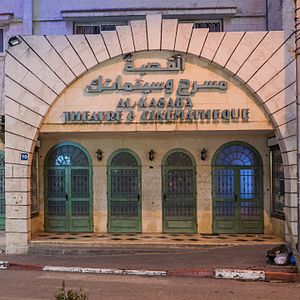
Al-Kasaba Theatre
Cinema in Ramallah, Palestine
Distance: Approx. 156 meters
Latitude and longitude: 31.90246944,35.20392222
Al-Kasaba Theatre and Cinematheque (Arabic: القصبة مسرح وسينماتك) is a cinema in the city of Ramallah, West Bank, Palestine. It was established in 1970 during Israeli occupation for playwrights and eventually began presenting films. Al-Kasaba is the only official multipurpose cinema in the Palestinian territories.
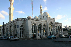
Jamal Abdel Nasser Mosque
Mosque in the city of Al-Bireh, Ramallah and Al-Bireh Governorate, Palestine
Distance: Approx. 390 meters
Latitude and longitude: 31.90396389,35.20752222
Jamal Abdel Nasser Mosque (Arabic: مسجد جمال عبد الناصر Masjid Jamal 'Abd an-Nasser) is the largest mosque in al-Bireh, West Bank, Palestine. Located in the Downtown district of the city, the mosque is named after the late Egyptian president and Arab leader Gamal Abdel Nasser. On March 14, 2002, the Israeli Army (IDF) took over the mosque and used its minaret for sniping, killing four Palestinians.
Qaddura
Refugee Camp in Ramallah and al-Bireh, State of Palestine
Distance: Approx. 397 meters
Latitude and longitude: 31.90092222,35.20588333
Qaddura Refugee Camp (Arabic: مخيّم قدورة) is a Palestinian refugee camp in the Ramallah and al-Bireh Governorate, located just outside downtown Ramallah in the central West Bank. According to the Palestinian Central Bureau of Statistics (PCBS), the Camp had a population of 924 inhabitants in 2017. Qaddura camp was established in 1948, but is not recognized as an official UNRWA camp.
Orjuwan
Restaurant and nightclub in Ramallah
Distance: Approx. 692 meters
Latitude and longitude: 31.89835,35.19987
Orjuwan is an upscale restaurant and nightclub in Ramallah. Orjuwan is located in the "fashionable" Ramallah neighborhood of Al-Masyoun. The restaurant was opened in 2009 by two brothers and a sister from the well-known Sakakini family, Sari, Salim; their sister, Katia.

Al-Manara Square
Square in Ramallah, West Bank, Palestine
Distance: Approx. 166 meters
Latitude and longitude: 31.905,35.20444444
Al-Manara Square (Arabic: ميدان المنارة) is a town square located in Ramallah, West Bank, Palestine.
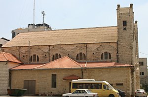
Holy Family Church, Ramallah
Church in Ramallah, Palestine
Distance: Approx. 374 meters
Latitude and longitude: 31.905,35.1997
Holy Family Church (Arabic: كنيسة العائلة المقدسة) is a Catholic Church located in Ramallah, in the West Bank, in the State of Palestine.
List of ambassadors of China to the State of Palestine
Distance: Approx. 281 meters
Latitude and longitude: 31.905843,35.201653
The Chinese Ambassador to Palestine is the official representative of the People's Republic of China to the State of Palestine.
Weather in this IP's area
clear sky
19 Celsius
19 Celsius
18 Celsius
19 Celsius
1013 hPa
77 %
1013 hPa
915 hPa
10000 meters
4.53 m/s
6.95 m/s
288 degree
2 %
06:24:29
18:42:56