Country:
 Germany
Region:
City:
Latitude and Longitude:
Time Zone:
Postal Code:
IP information under different IP Channel
ip-api
Country
Region
City
ASN
Time Zone
ISP
Blacklist
Proxy
Latitude
Longitude
Postal
Route
IPinfo
Country
Region
City
ASN
Time Zone
ISP
Blacklist
Proxy
Latitude
Longitude
Postal
Route
MaxMind
Country
Region
City
ASN
Time Zone
ISP
Blacklist
Proxy
Latitude
Longitude
Postal
Route
Luminati
Country
DERegion
hh
City
hamburg
ASN
Time Zone
Europe/Berlin
ISP
wilhelm.tel GmbH
Latitude
Longitude
Postal
db-ip
Country
Region
City
ASN
Time Zone
ISP
Blacklist
Proxy
Latitude
Longitude
Postal
Route
ipdata
Country
Region
City
ASN
Time Zone
ISP
Blacklist
Proxy
Latitude
Longitude
Postal
Route
Popular places and events near this IP address
Otto Group
German multinational e-commerce company
Distance: Approx. 1789 meters
Latitude and longitude: 53.60088056,10.07253333
The Otto Group (Otto (GmbH & Co KG)) is a German retail company based in Hamburg that operates companies worldwide in the retail, e-commerce, financing, logistics and mail order sectors. In 2023, the Group generated sales of €16.2 billion and had around 41,186 employees.

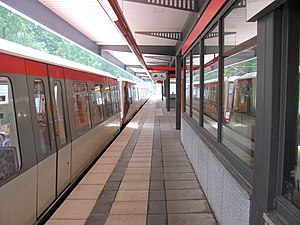
Barmbek station
Railway station and transport hub in Hamburg, Germany
Distance: Approx. 1912 meters
Latitude and longitude: 53.58694444,10.04472222
Barmbek is a railway station and transport hub in Hamburg, Germany, for the underground railway (U-Bahn) system and the suburban railway (S-Bahn) system. The station is located in the district of Barmbek-Nord, Germany. Barmbek-Nord is part of the borough of Hamburg-Nord.

Ohlsdorf Jewish Cemetery
Jewish cemetery in Hamburg
Distance: Approx. 1230 meters
Latitude and longitude: 53.61444444,10.03944444
The Jewish cemetery Ohlsdorf (German: Jüdischer Friedhof Ohlsdorf or Jüdischer Friedhof Ilandkoppel) also known as Ilandkoppel Jewish Cemetery is a Jewish cemetery in the Ohlsdorf district of Hamburg, Germany. It is the only operating Jewish cemetery in Hamburg and still used for burials according to the Jewish ritual and tradition. It is adjacent to the large non-denominational Ohlsdorf Cemetery where more than 1.5 million people are buried.

Hamburg Stadtpark
Park in Hamburg, Germany
Distance: Approx. 1569 meters
Latitude and longitude: 53.598745,10.02403
Hamburg Stadtpark (Hamburger Stadtpark) is a large urban park in the district of Winterhude, in the Hamburg borough of Hamburg-Nord. Spanning an area of 148 hectares (366 acres), it is the second-largest park in the city after Altona Volkspark. The Stadtpark is regarded as the "green heart" of Hamburg, despite being located some 3 km from the city centre.

Habichtstraße station
Railway station in Hamburg, Germany
Distance: Approx. 1232 meters
Latitude and longitude: 53.59361111,10.05194444
Habichtstraße is an elevated rapid transit station located in the Hamburg district of Barmbek-Nord, Germany. The station was opened in 1930 and is served by Hamburg U-Bahn line U3.

Alte Wöhr station
Railway station in Hamburg, Germany
Distance: Approx. 1008 meters
Latitude and longitude: 53.5975,10.03555556
Alte Wöhr is a station on the Hamburg-Altona link line and served by the trains of Hamburg S-Bahn line S1. The station is also known as Alte Wöhr (Stadtpark), due to its proximity to Hamburg Stadtpark. It was opened in 1931 and is located in the Hamburg district of Barmbek-Nord, Germany.

Rübenkamp station
Railway station in Hamburg, Germany
Distance: Approx. 892 meters
Latitude and longitude: 53.60638889,10.03305556
Rübenkamp is a station on the Hamburg-Altona link line and served by the trains of Hamburg S-Bahn line S1. The station is also known as Rübenkamp (City Nord), due to its proximity to City Nord. It was opened in 1913 and is located in the Hamburg district of Barmbek-Nord, Germany.
Sengelmannstraße station
Railway station in Hamburg, Germany
Distance: Approx. 1697 meters
Latitude and longitude: 53.60944444,10.02194444
Sengelmannstraße is a metro station on the Hamburg U-Bahn line U1. The station was opened in September 1975 and is located in the Hamburg district of Alsterdorf, Germany. Alsterdorf is part of the borough of Hamburg-Nord.
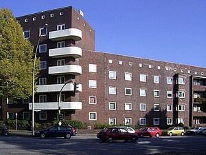
Barmbek-Nord
Quarter of Hamburg in Germany
Distance: Approx. 421 meters
Latitude and longitude: 53.6052,10.0399
(Northern Barmbek) is a quarter of Hamburg, Germany, in the borough of Hamburg-Nord. It is located in the east of Hamburg-Nord, approximately five kilometers from Hamburg city center. Barmbek-Nord is a densely built-up area.

Bramfeld
Quarter of Hamburg in Germany
Distance: Approx. 1821 meters
Latitude and longitude: 53.608611,10.0725
Bramfeld () is a quarter of Hamburg, Germany, in the borough of Wandsbek. It is located on the southeastern border of the borough, which lies in the northeastern part of the city. Bramfeld includes the former village of Hellbrook, but consists today out of residential as well as of commercial areas.
Edekabank
Distance: Approx. 1713 meters
Latitude and longitude: 53.60295,10.02014
The Edekabank AG is a universal bank and a business of the Edeka Group located at the Edeka House, New-York-Ring 6 in the City Nord in Hamburg. The bank is the central financing institute of Edeka grocery retailers and is active in consumer banking as a direct bank with online and phone consulting.

Steilshoop
Quarter in Hamburg, Germany
Distance: Approx. 788 meters
Latitude and longitude: 53.60833333,10.05555556
Steilshoop (German pronunciation: [ˈʃtaɪ̯lsˌhoːp] ) is a quarter of Hamburg, Germany in the Wandsbek borough.
Weather in this IP's area
clear sky
13 Celsius
13 Celsius
12 Celsius
14 Celsius
1027 hPa
92 %
1027 hPa
1024 hPa
10000 meters
3.09 m/s
330 degree
06:57:18
19:31:20