Country:
 Malta
MaltaRegion:
City:
Latitude and Longitude:
Time Zone:
Postal Code:
IP information under different IP Channel
ip-api
Country
Region
City
ASN
Time Zone
ISP
Blacklist
Proxy
Latitude
Longitude
Postal
Route
IPinfo
Country
Region
City
ASN
Time Zone
ISP
Blacklist
Proxy
Latitude
Longitude
Postal
Route
MaxMind
Country
Region
City
ASN
Time Zone
ISP
Blacklist
Proxy
Latitude
Longitude
Postal
Route
Luminati
Country
MTASN
Time Zone
Europe/Malta
ISP
Melita Limited
Latitude
Longitude
Postal
db-ip
Country
Region
City
ASN
Time Zone
ISP
Blacklist
Proxy
Latitude
Longitude
Postal
Route
ipdata
Country
Region
City
ASN
Time Zone
ISP
Blacklist
Proxy
Latitude
Longitude
Postal
Route
Popular places and events near this IP address
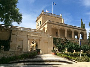
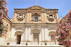
San Anton Palace
Palace in Attard, Malta
Distance: Approx. 1169 meters
Latitude and longitude: 35.89638889,14.44666667
San Anton Palace (Maltese: Il-Palazz Sant'Anton) is a palace in Attard, Malta, that currently serves as the official residence of the president of Malta. It was originally built in the early 17th century as a country villa for Antoine de Paule, a knight of the Order of St. John.

Malta (island)
Largest island of the Maltese Archipelago
Distance: Approx. 1143 meters
Latitude and longitude: 35.88333333,14.45
Malta is an island in Southern Europe. It is the largest and most populous of the three major islands that constitute the Maltese Archipelago.The island is situated in the Mediterranean Sea directly south of Italy and north of Libya. It lies south-east of the smaller islands of Gozo and Comino.The island is 27 kilometres (17 mi) long and 14.5 kilometres (9 mi) wide, with a total area of 246 square kilometres (95 sq mi).

Birkirkara
Local council in Eastern Region, Malta
Distance: Approx. 722 meters
Latitude and longitude: 35.89666667,14.4625
Birkirkara (abbreviated as B'Kara or BKR) is a city in the eastern region of Malta. It is the second most populous on the island, with 24,356 inhabitants as of 2020. The town consists of five autonomous parishes: Saint Helen, Saint Joseph the Worker, Our Lady of Mount Carmel, Saint Mary and San Gorg Preca.
Balzan
Local council in Central Region, Malta
Distance: Approx. 862 meters
Latitude and longitude: 35.89805556,14.45333333
Balzan (Maltese: Ħal Balzan) is a municipality in the Central Region of Malta, one of the so-called three villages, together with Attard and Lija. The village originally consisted of a group of small dwellings and farms but eventually grew, becoming a parish in the 17th century. As of 2021, the town registered a population of 4,774 inhabitants.
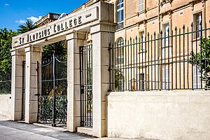
St Aloysius' College (Malta)
School in Birkirkara Malta
Distance: Approx. 557 meters
Latitude and longitude: 35.895979,14.460183
St Aloysius College (SAC) is a Catholic primary, secondary and post-secondary education institution run by the Euro-Mediterranean Province of the Society of Jesus in Birkirkara, Malta. It was founded by the Jesuits in 1907 to complement the seminaries and tertiary institutions already in existence on the island. Today, it comprises a coeducational primary school, boys' secondary school, and a coeducational sixth form.

State of Malta
Country from 1964 to 1974
Distance: Approx. 1143 meters
Latitude and longitude: 35.88333333,14.45
The State of Malta (Maltese: Stat ta’ Malta), commonly known as Malta, was the predecessor to the modern-day Republic of Malta. It existed between 21 September 1964 and 13 December 1974. The Crown Colony of Malta became independent under the Malta Independence Act 1964 (c.

Wignacourt Aqueduct
17th-century aqueduct in Malta
Distance: Approx. 322 meters
Latitude and longitude: 35.89305556,14.46083333
The Wignacourt Aqueduct (Maltese: L-Akwedott ta' Wignacourt) is a 17th-century aqueduct in Malta, which was built by the Order of Saint John to carry water from springs in Dingli and Rabat to the newly built capital city Valletta. The aqueduct carried water through underground pipes and over arched viaducts across depressions in the ground. The first attempts to build the aqueduct were made by Grand Master Martin Garzez in 1596, but construction was suspended before being continued in 1610.
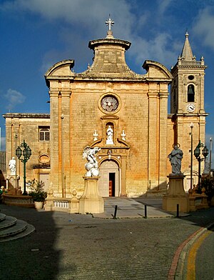
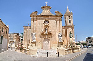
Parish Church of St. Mary, Birkirkara
Church in Birkirkara, Malta
Distance: Approx. 614 meters
Latitude and longitude: 35.895,14.46305556
The Parish Church of Saint Mary (Maltese: Il-Knisja ta' Santa Marija), commonly known as il-Knisja l-Qadima (the old church) is a Roman Catholic parish church in Birkirkara, Malta, dedicated to the Assumption of Mary. It was built in the 17th century, and it has a Renaissance design attributed to the architects Vittorio Cassar and Tommaso Dingli. The church fell out of use when St Helen's Basilica replaced it as Birkirkara's parish church in the 18th century.
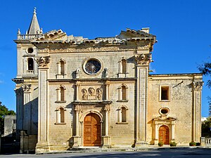
Church of St Alphonse Liguori, Birkirkara
Church in Birkirkara, Malta
Distance: Approx. 645 meters
Latitude and longitude: 35.89708333,14.45838889
The Church of St Alphonse Liguori (Maltese: Il-Knisja ta' San Alfons Liguori) is a Roman Catholic church in Birkirkara, Malta. It was operated by the Discalced Carmelites, and was dedicated to Saint Alphonsus Maria de' Liguori. The church is currently used as a meeting hall known as Our Lady of Mount Carmel Hall (Maltese: Sala Madonna tal-Karmnu).
Annunciation Church, Balzan
Church in Balzan, Malta
Distance: Approx. 1013 meters
Latitude and longitude: 35.8987,14.451464
The Parish Church of the Annunciation is one of the Roman Catholic parish churches located in the village of Balzan, Malta.

Ta' Ganu Windmill
18th-century structure in Malta
Distance: Approx. 979 meters
Latitude and longitude: 35.89993,14.4559
Ta' Ganu Windmill (also known as Tal-Maħlut Windmill) is an eighteenth century windmill in Birkirkara, Malta. It was built in 1724 by the António Manoel de Vilhena Foundation. "Maħlut", the alternative name also used for it historically, is the Maltese word for a mixture of wheat and hops used for making bread.
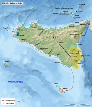
Capture of Malta (218 BC)
Invasion of Malta by the Roman Republic in 218 BC
Distance: Approx. 1143 meters
Latitude and longitude: 35.88333333,14.45
The capture of Malta was the successful invasion of the Carthaginian island of Malta (then known as Maleth, Melite or Melita) by forces of the Roman Republic led by Tiberius Sempronius Longus in the early stages of the Second Punic War in 218 BC.
Weather in this IP's area
clear sky
22 Celsius
23 Celsius
22 Celsius
23 Celsius
1013 hPa
88 %
1013 hPa
1007 hPa
10000 meters
1.03 m/s
300 degree
06:47:59
19:03:53