Country:
Region:
City:
Latitude and Longitude:
Time Zone:
Postal Code:
IP information under different IP Channel
ip-api
Country
Region
City
ASN
Time Zone
ISP
Blacklist
Proxy
Latitude
Longitude
Postal
Route
Luminati
Country
ASN
Time Zone
Europe/Lisbon
ISP
Servicos De Comunicacoes E Multimedia S.A.
Latitude
Longitude
Postal
IPinfo
Country
Region
City
ASN
Time Zone
ISP
Blacklist
Proxy
Latitude
Longitude
Postal
Route
db-ip
Country
Region
City
ASN
Time Zone
ISP
Blacklist
Proxy
Latitude
Longitude
Postal
Route
ipdata
Country
Region
City
ASN
Time Zone
ISP
Blacklist
Proxy
Latitude
Longitude
Postal
Route
Popular places and events near this IP address

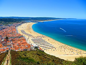
Nazaré, Portugal
Municipality in Oeste e Vale do Tejo, Portugal
Distance: Approx. 9977 meters
Latitude and longitude: 39.60111111,-9.07055556
Nazaré (Portuguese pronunciation: [nɐzɐˈɾɛ] ) is a Portuguese town and municipality located in the Oeste region, in the historical province of Estremadura, and in the Leiria District. The municipality has a population of 14,889 in an area of 82.43 km2, while the town itself has around 10,000 inhabitants. It is one of the most popular seaside resorts in the Silver Coast (Costa de Prata).
Valado dos Frades
Civil parish in Oeste e Vale do Tejo, Portugal
Distance: Approx. 9212 meters
Latitude and longitude: 39.589,-9.019
Valado dos Frades is a Portuguese parish in the municipality of Nazaré. The population in 2011 was 3,109, in an area of 18.51 km².

Sanctuary of Our Lady of Nazaré
Church in Nazaré, Portugal
Distance: Approx. 9967 meters
Latitude and longitude: 39.6055,-9.0767
The Sanctuary of Our Lady of Nazaré is a Marian shrine that memorializes an ancient miracle that occurred under the intercession of the Virgin Mary. It is located on the hilltop called O Sítio, overlooking Nazaré, in Portugal, and was founded in the 14th century.
Alcobaça Formation
Geological formation in Portugal
Distance: Approx. 7778 meters
Latitude and longitude: 39.6,-9
The Alcobaça Formation, previously known as the Guimarota Formation and also known as the Consolação Unit, is a geological formation in Portugal. It dates back to the Kimmeridgian stage of the Late Jurassic. It is an important source of information on the diversity of Late Jurassic mammals.

Nazaré Funicular
Funicular in Nazaré, Portugal
Distance: Approx. 9870 meters
Latitude and longitude: 39.60502778,-9.07441667
The Nazaré Funicular (Portuguese: Ascensor da Nazaré) is a funicular situated in the civil parish of Nazaré, Portugal, municipality of Nazaré, in the portuguese Oeste region.

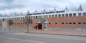
Estádio Municipal da Marinha Grande
Distance: Approx. 9289 meters
Latitude and longitude: 39.736977,-8.931459
Estádio Municipal da Marinha Grande is a football stadium in Marinha Grande, Portugal. It hosts football matches for Atlético Clube Marinhense and hosted the home matches of U.D. Leiria in 2002-03 when Estádio Dr. Magalhães Pessoa was being renovated.

Pederneira
Distance: Approx. 9592 meters
Latitude and longitude: 39.606,-9.071
Pederneira is a former village in Portugal, and currently part of the larger city of Nazaré, Portugal on the coast of the Atlantic Ocean.

Ermida da Memória da Nazaré
Church in Nazaré, Portugal
Distance: Approx. 9998 meters
Latitude and longitude: 39.60463,-9.07605
Memory Hermitage, also known as the Chapel of Our Lady of Nazaré (Portuguese: Ermida da Memória / Capela de Nossa Senhora da Nazaré), is located on the edge of promontory in Nazaré, Portugal. It is a four-sided chapel decorated with blue and white tiles and has a pyramidal roof.

Nazaré Bullring
Bullfighting arena in Nazaré, Portugal
Distance: Approx. 9696 meters
Latitude and longitude: 39.60638889,-9.07333333
The Nazaré bullring (Portuguese: Praça de Touros da Nazaré) is situated on the west coast of Portugal in the village of Sitio in Nazaré, historic Estremadura province. The present bullring was built in 1897 in neo-Arab style and continues to be used for bullfights and other entertainment. An earlier bullring was destroyed by fire.

Praia de Vale Furado
Portuguese location
Distance: Approx. 5543 meters
Latitude and longitude: 39.68333333,-9.05805556
Praia de Vale Furado is a beach located in Pataias, Leiria District, in central Portugal, roughly between Nazaré and São Pedro de Moel. The beach is part of the Portuguese Costa de Prata and is renowned not only for its sandstone cliffs but also its geological heritage: part of the Feligueira Grande formation, the extinct genus of Iberosuchus, a mesoeucrocodylian, was first described here in 1975, a tapir (Paralophiodon cf. leptorhynchum) was also found in addition to other unidentified crocodiles, chelonians and small mammals.
Maceira (Leiria)
Civil parish in Centro, Portugal
Distance: Approx. 8345 meters
Latitude and longitude: 39.68333333,-8.9
Maceira is a village and a civil parish of the municipality of Leiria, Portugal. The population in 2011 was 2,004, in an area of 47.03 km2.
Weather in this IP's area
overcast clouds
14 Celsius
13 Celsius
13 Celsius
14 Celsius
1016 hPa
81 %
1016 hPa
1001 hPa
10000 meters
4.91 m/s
11.06 m/s
115 degree
100 %
07:23:08
17:19:11
