Country:
Region:
City:
Latitude and Longitude:
Time Zone:
Postal Code:
IP information under different IP Channel
ip-api
Country
Region
City
ASN
Time Zone
ISP
Blacklist
Proxy
Latitude
Longitude
Postal
Route
Luminati
Country
Region
07
City
evora
ASN
Time Zone
Europe/Lisbon
ISP
Servicos De Comunicacoes E Multimedia S.A.
Latitude
Longitude
Postal
IPinfo
Country
Region
City
ASN
Time Zone
ISP
Blacklist
Proxy
Latitude
Longitude
Postal
Route
db-ip
Country
Region
City
ASN
Time Zone
ISP
Blacklist
Proxy
Latitude
Longitude
Postal
Route
ipdata
Country
Region
City
ASN
Time Zone
ISP
Blacklist
Proxy
Latitude
Longitude
Postal
Route
Popular places and events near this IP address

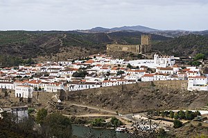
Mértola
Municipality in Alentejo, Portugal
Distance: Approx. 303 meters
Latitude and longitude: 37.64027778,-7.66111111
Mértola (Portuguese pronunciation: [ˈmɛɾtulɐ] ) is a town and municipality in southeastern Portuguese Alentejo near the Spanish border. In 2011, the population was 7,274, in an area of approximately 1,292.87 square kilometres (499.18 sq mi): it is the sixth-largest municipality in Portugal. Meanwhile, it is the second-lowest population centre by density with approximately 5.62 persons/1 square kilometre (0.39 sq mi) (second to the adjacent Alcoutim).

Guadiana Valley Natural Park
Distance: Approx. 1650 meters
Latitude and longitude: 37.65055556,-7.645
Guadiana Valley Natural Park (Portuguese: Parque Natural do Vale do Guadiana) is a natural park in southeastern Portugal. It is one of the 30 areas which are officially under protection in the country. The top of the flow gage tower was reached by the Guadiana twice in 50 years.

Ponte de Mértola
Bridge in Beja, Portugal
Distance: Approx. 846 meters
Latitude and longitude: 37.63580556,-7.66419444
The Ponte Velha de Mértola ("Old Bridge of Mértola"), also referred to as the Ponte Branca or Torre do Rio, is a structure located along the Guadiana River, in the civil parish of Mértola, municipality of Mértola, in the Portuguese district of Beja. Although named a bridge, the structure is the remains of a wharf and fortified port, linked to the defensive curtain of the walled city.

Church of Nossa Senhora da Anunciação
Church in Alentejo, Portugal
Distance: Approx. 565 meters
Latitude and longitude: 37.63833333,-7.66361111
The Church of Nossa Senhora da Anunciação (Portuguese: Igreja Paroquial de Mértola/Igreja de Nossa Senhora da Assunção/Igreja de Nossa Senhora da Anunciação) is a 12th-century church and former mosque in the civil parish of Mértola in the municipality of Mértola, in the Portuguese Alentejo.

Myrtilis Iulia
Roman Municipium in times of Augustus, present day Mértola, Portugal
Distance: Approx. 303 meters
Latitude and longitude: 37.64027778,-7.66111111
Myrtilis Iulia was the Roman name given to present day Mértola, Portugal. During Classical Antiquity, Mértola was inhabited by Phoenicians, Carthaginians and finally the Romans, who called it Myrtilis Iulia. The region was inhabited at least since the Iron Age at least by the Conni and Cynetes and was influenced by the Phoenicians.

Castle of Mertola
Castle in Mértola, Portugal
Distance: Approx. 503 meters
Latitude and longitude: 37.639,-7.66375
The Castle of Mértola (Portuguese: Castelo de Mértola) is a well-preserved medieval castle located in the civil parish and municipality of Mértola, in the Portuguese district of Beja.
Weather in this IP's area
overcast clouds
15 Celsius
15 Celsius
15 Celsius
15 Celsius
1016 hPa
86 %
1016 hPa
1009 hPa
10000 meters
1.1 m/s
3.43 m/s
134 degree
100 %
07:13:09
17:18:29