Country:
 Czech Republic
Region:
City:
Latitude and Longitude:
Time Zone:
Postal Code:
IP information under different IP Channel
ip-api
Country
Region
City
ASN
Time Zone
ISP
Blacklist
Proxy
Latitude
Longitude
Postal
Route
IPinfo
Country
Region
City
ASN
Time Zone
ISP
Blacklist
Proxy
Latitude
Longitude
Postal
Route
MaxMind
Country
Region
City
ASN
Time Zone
ISP
Blacklist
Proxy
Latitude
Longitude
Postal
Route
Luminati
Country
CZRegion
71
City
prostejov
ASN
Time Zone
Europe/Prague
ISP
Quantcom, a.s.
Latitude
Longitude
Postal
db-ip
Country
Region
City
ASN
Time Zone
ISP
Blacklist
Proxy
Latitude
Longitude
Postal
Route
ipdata
Country
Region
City
ASN
Time Zone
ISP
Blacklist
Proxy
Latitude
Longitude
Postal
Route
Popular places and events near this IP address

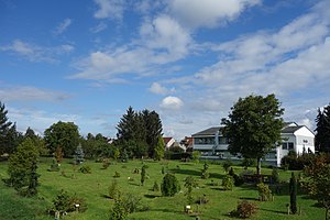
Prostějov
City in Olomouc Region, Czech Republic
Distance: Approx. 872 meters
Latitude and longitude: 49.47222222,17.11055556
Prostějov (Czech pronunciation: [ˈproscɛjof] ; German: Proßnitz) is a city in the Olomouc Region of the Czech Republic. It has about 44,000 inhabitants. The city is historically known for its fashion industry.

Vrahovice
Village in Czech Republic
Distance: Approx. 2444 meters
Latitude and longitude: 49.48083333,17.14833333
Vrahovice is a village and administrative part of Prostějov in the Olomouc Region of the Czech Republic. It has about 3,300 inhabitants.

Držovice
Municipality in Olomouc, Czech Republic
Distance: Approx. 1909 meters
Latitude and longitude: 49.49111111,17.13416667
Držovice is a municipality and village in Prostějov District in the Olomouc Region of the Czech Republic. It has about 1,600 inhabitants. Držovice lies approximately 3 kilometres (2 mi) north-east of Prostějov, 15 km (9 mi) south-west of Olomouc, and 206 km (128 mi) east of Prague.
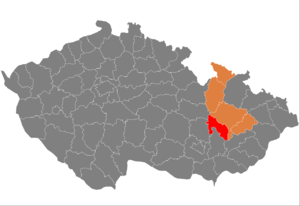
Prostějov District
District in Olomouc, Czech Republic
Distance: Approx. 2504 meters
Latitude and longitude: 49.5,17.1
Prostějov District (Czech: okres Prostějov) is a district in the Olomouc Region of the Czech Republic. Its capital is the city of Prostějov.

Smržice
Municipality in Olomouc, Czech Republic
Distance: Approx. 2972 meters
Latitude and longitude: 49.50583333,17.10694444
Smržice is a municipality and village in Prostějov District in the Olomouc Region of the Czech Republic. It has about 1,600 inhabitants. Smržice lies approximately 4 kilometres (2 mi) north of Prostějov, 15 km (9.3 mi) south-west of Olomouc, and 204 km (127 mi) east of Prague.

National House, Prostějov
Distance: Approx. 667 meters
Latitude and longitude: 49.47361111,17.11472222
The National House (Czech: Národní dům) is a historical building in Prostějov in the Czech Republic. It was built for cultural and social purposes. It is a significant cultural monument of the city.
St. Bartholomew's Church, Vrahovice
Distance: Approx. 2491 meters
Latitude and longitude: 49.48166667,17.14888889
St. Bartholomew's Church (Czech: Kostel svatého Bartoloměje) is a baroque building which was built from 1831 to 1836 and which is used by a Catholic Church. It lies at the main square in Vrahovice.
Arboretum Vrahovice
Arboretum in Vrahovice, Czech Republic
Distance: Approx. 2199 meters
Latitude and longitude: 49.4796,17.145
The Arboretum Vrahovice is a small arboretum in Vrahovice, Czech Republic. The Arboretum Vrahovice was established by Spolek za staré Vrahovice in 2010 and developed between 2010 and 2015. The Arboretum contains trees and bushes originating from North America, Europe and Asia.

Church of the Exaltation of the Holy Cross, Prostějov
Church in Prostějov, Czech Republic
Distance: Approx. 890 meters
Latitude and longitude: 49.47176111,17.11218611
The Church of the Exaltation of the Holy Cross (Czech: Kostel Povýšení svatého Kříže) is a Catholic parish church in Prostějov in the Olomouc Region of the Czech Republic. It is dedicated to the Exaltation of the Holy Cross. The building is the landmark of the city and it is its oldest monument.
Bloody Sunday (1968)
Soviet attack on civilians during Warsaw Pact invasion of Czechoslovakia
Distance: Approx. 980 meters
Latitude and longitude: 49.4724,17.1068
Bloody Sunday was a massacre on 25 August 1968 when Soviet soldiers shot three unarmed civilians in Prostějov during Warsaw Pact invasion of Czechoslovakia. Nine others were injured.

Beth ha-midrash synagogue
Former synagogue in the Czech Republic
Distance: Approx. 864 meters
Latitude and longitude: 49.47186,17.11367
The Beth ha-midrash synagogue (Hebrew: בית המדרש, Czech: synagoga Bet ha-midraš) is a former Jewish synagogue and bet midrash, located in Prostějov, in the Olomouc Region of the Czech Republic.
TK Agrofert Prostějov
Tennis club in Prostějov, Czech Republic
Distance: Approx. 1037 meters
Latitude and longitude: 49.4813,17.1005
TK Agrofert Prostějov is a tennis club and training center located in Prostějov, Czech Republic. It is one of the most prestigious tennis clubs in the country.
Weather in this IP's area
scattered clouds
15 Celsius
14 Celsius
14 Celsius
17 Celsius
1021 hPa
44 %
1021 hPa
994 hPa
10000 meters
7.4 m/s
12.79 m/s
159 degree
27 %
07:17:36
17:55:21