46.29.228.116 - IP Lookup: Free IP Address Lookup, Postal Code Lookup, IP Location Lookup, IP ASN, Public IP
Country:
Region:
City:
Location:
Time Zone:
Postal Code:
IP information under different IP Channel
ip-api
Country
Region
City
ASN
Time Zone
ISP
Blacklist
Proxy
Latitude
Longitude
Postal
Route
Luminati
Country
Region
42
City
chomutov
ASN
Time Zone
Europe/Prague
ISP
ISP Alliance a.s.
Latitude
Longitude
Postal
IPinfo
Country
Region
City
ASN
Time Zone
ISP
Blacklist
Proxy
Latitude
Longitude
Postal
Route
IP2Location
46.29.228.116Country
Region
ustecky kraj
City
lenesice
Time Zone
Europe/Prague
ISP
Language
User-Agent
Latitude
Longitude
Postal
db-ip
Country
Region
City
ASN
Time Zone
ISP
Blacklist
Proxy
Latitude
Longitude
Postal
Route
ipdata
Country
Region
City
ASN
Time Zone
ISP
Blacklist
Proxy
Latitude
Longitude
Postal
Route
Popular places and events near this IP address
Louny
Town in the Czech Republic
Distance: Approx. 2977 meters
Latitude and longitude: 50.35722222,13.79694444
Louny (Czech pronunciation: [ˈlounɪ]; German: Laun) is a town in the Ústí nad Labem Region of the Czech Republic. It has about 18,000 inhabitants. It lies on the Ohře river.
Postoloprty
Town in Ústí nad Labem, Czech Republic
Distance: Approx. 5235 meters
Latitude and longitude: 50.36055556,13.69583333
Postoloprty (Czech pronunciation: [ˈpostolopr̩tɪ]; German: Postelberg) is a town in Louny District in the Ústí nad Labem Region of the Czech Republic. It has about 4,700 inhabitants.

St. Nicholas Church, Louny
Church in Louny, Czech Republic
Distance: Approx. 2889 meters
Latitude and longitude: 50.35725,13.79528
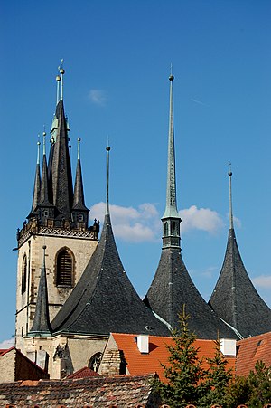
St. Nicholas Church in Louny (Czech: Chrám svatého Mikuláše v Lounech) is a Roman Catholic, parochial church dedicated to Saint Nicholas, located in Louny, Czech Republic. The 1517 fire destroyed the nave and damaged the tower of the original church.

Břvany
Municipality in Ústí nad Labem, Czech Republic
Distance: Approx. 4263 meters
Latitude and longitude: 50.40111111,13.72166667
Břvany (German: Weberschan) is a municipality and village in Louny District in the Ústí nad Labem Region of the Czech Republic. It has about 300 inhabitants. Břvany lies approximately 8 kilometres (5 mi) north-west of Louny, 36 km (22 mi) south-west of Ústí nad Labem, and 61 km (38 mi) north-west of Prague.
Chraberce
Municipality in Ústí nad Labem, Czech Republic
Distance: Approx. 5841 meters
Latitude and longitude: 50.40833333,13.82972222
Chraberce is a municipality and village in Louny District in the Ústí nad Labem Region of the Czech Republic. It has about 100 inhabitants. Chraberce lies approximately 7 kilometres (4 mi) north of Louny, 32 km (20 mi) south-west of Ústí nad Labem, and 56 km (35 mi) north-west of Prague.

Cítoliby
Market town in Ústí nad Labem, Czech Republic
Distance: Approx. 5756 meters
Latitude and longitude: 50.33277778,13.81222222
Cítoliby (until 1923 Citoliby; German: Zittolib) is a market town in Louny District in the Ústí nad Labem Region of the Czech Republic. It has about 1,100 inhabitants.

Dobroměřice
Municipality in Ústí nad Labem, Czech Republic
Distance: Approx. 2118 meters
Latitude and longitude: 50.37027778,13.79472222
Dobroměřice is a municipality and village in Louny District in the Ústí nad Labem Region of the Czech Republic. It has about 1,400 inhabitants. Dobroměřice lies approximately 3 kilometres (2 mi) north of Louny, 37 km (23 mi) southwest of Ústí nad Labem, and 56 km (35 mi) northwest of Prague.
Lenešice
Municipality in Ústí nad Labem, Czech Republic
Distance: Approx. 17 meters
Latitude and longitude: 50.37527778,13.76611111
Lenešice (German: Leneschitz) is a municipality and village in Louny District in the Ústí nad Labem Region of the Czech Republic. It has about 1,400 inhabitants. Lenešice lies approximately 4 kilometres (2 mi) north-west of Louny, 37 km (23 mi) south-west of Ústí nad Labem, and 57 km (35 mi) north-west of Prague.

Raná (Louny District)
Municipality in Ústí nad Labem, Czech Republic
Distance: Approx. 4172 meters
Latitude and longitude: 50.41166667,13.77944444
Raná (German: Rannay) is a municipality and village in Louny District in the Ústí nad Labem Region of the Czech Republic. It has about 200 inhabitants. Raná lies approximately 7 kilometres (4 mi) north of Louny, 34 km (21 mi) south-west of Ústí nad Labem, and 59 km (37 mi) north-west of Prague.
Vršovice (Louny District)
Municipality in Ústí nad Labem, Czech Republic
Distance: Approx. 5468 meters
Latitude and longitude: 50.36861111,13.84222222
Vršovice is a municipality and village in Louny District in the Ústí nad Labem Region of the Czech Republic. It has about 200 inhabitants. Vršovice lies approximately 4 kilometres (2 mi) north-east of Louny, 35 km (22 mi) south-west of Ústí nad Labem and 53 km (33 mi) north-west of Prague.
Chomutovka
River in Ústí nad Labem, Czech Republic
Distance: Approx. 3680 meters
Latitude and longitude: 50.3625,13.71805556
The Chomutovka is a river in the Czech Republic, a left tributary of the Ohře River. It flows through the Ústí nad Labem Region. It is 50.4 km (31.3 mi) long.

Postoloprty Castle
Baroque castle in Postoloprty, Czech Republic
Distance: Approx. 4961 meters
Latitude and longitude: 50.3590775,13.7007604
Postoloprty Castle (Czech: Zámek Postoloprty; German: Schloss Postelberg) is a Baroque palace in Postoloprty in the Czech Republic. The castle was constructed in the 17th century on the location of a former monastery. It was a seat of the princely Schwarzenberg family until the Second World War, when it was confiscated, first by the German Reich and afterwards by the Czechoslovakian Government.
Weather in this IP's area
broken clouds
2 Celsius
-3 Celsius
1 Celsius
3 Celsius
1020 hPa
82 %
1020 hPa
997 hPa
10000 meters
5.81 m/s
8.05 m/s
335 degree
76 %


