Country:
 Cyprus
Region:
City:
Latitude and Longitude:
Time Zone:
Postal Code:
IP information under different IP Channel
ip-api
Country
Region
City
ASN
Time Zone
ISP
Blacklist
Proxy
Latitude
Longitude
Postal
Route
IPinfo
Country
Region
City
ASN
Time Zone
ISP
Blacklist
Proxy
Latitude
Longitude
Postal
Route
MaxMind
Country
Region
City
ASN
Time Zone
ISP
Blacklist
Proxy
Latitude
Longitude
Postal
Route
Luminati
Country
CYRegion
01
City
ayiosdhometios
ASN
Time Zone
Asia/Nicosia
ISP
Primetel PLC
Latitude
Longitude
Postal
db-ip
Country
Region
City
ASN
Time Zone
ISP
Blacklist
Proxy
Latitude
Longitude
Postal
Route
ipdata
Country
Region
City
ASN
Time Zone
ISP
Blacklist
Proxy
Latitude
Longitude
Postal
Route
Popular places and events near this IP address
Church of Cyprus
Christian Eastern Orthodox jurisdiction in Cyprus
Distance: Approx. 740 meters
Latitude and longitude: 35.1683,33.3362
The Church of Cyprus (Greek: Ἐκκλησία τῆς Κύπρου, romanized: Ekklisia tis Kyprou) is one of the autocephalous Greek Orthodox churches that together with other Eastern Orthodox churches form the communion of the Eastern Orthodox Church. It is one of the oldest Eastern Orthodox autocephalous churches; it claims to have always been independent, although it may have been subject to the Church of Antioch before its autocephaly was recognized in 431 at the Council of Ephesus. The bishop of the ancient capital, Salamis (renamed Constantia by Emperor Constantius II) was constituted metropolitan by Emperor Zeno, with the title archbishop.

Presidential Palace, Nicosia
Presidential Palace of the Republic of Cyprus
Distance: Approx. 998 meters
Latitude and longitude: 35.1556,33.3473
The Presidential Palace (Greek: Προεδρικό Μέγαρο; Turkish: Cumhurbaşkanlığı Sarayı) is the official residence and principal workplace of the president of Cyprus. It is located in the Strovolos area of Nicosia and is surrounded by a thick pine woodland.

The English School, Nicosia
Selective secondary school
Distance: Approx. 1558 meters
Latitude and longitude: 35.1512,33.3503
The English School is an independent selective secondary school in Nicosia, Cyprus. It has a rigorous selection process for admittance. It is one of the secondary schools in Nicosia designated to be bi-communal, with both Greek and Turkish Cypriots being educated at the school.
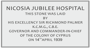
Nicosia Old General Hospital
Hospital in Nicosia, Cyprus
Distance: Approx. 1475 meters
Latitude and longitude: 35.172,33.353
Nicosia Old General Hospital was the chief hospital of Nicosia, Cyprus from 1936 to 2006. In 2006, its patients were transferred to the Nicosia New General Hospital, and it was demolished in 2010 amidst some controversy over whether it should have been preserved. The decision for erecting a purpose built general hospital in Nicosia was taken during the British colonial administration of Cyprus in 1936.
European University Cyprus
Distance: Approx. 444 meters
Latitude and longitude: 35.15944444,33.33888889
The European University Cyprus (EUC) (Greek: Ευρωπαϊκό Πανεπιστήμιο Κύπρου) is a private non- profit university in Nicosia, Cyprus which evolved out of Cyprus College, the oldest institution of higher education in Cyprus. EUC has a selective admission policy based on students' past academic record and performance. The institution has a current enrollment of over 8,500 students and provides internationally recognized undergraduate, graduate, and doctorate degrees.
United Nations High Commissioner for Refugees Representation in Cyprus
Diplomatic mission
Distance: Approx. 444 meters
Latitude and longitude: 35.1632048,33.3459768
The United Nations High Commissioner for Refugees Representation in Cyprus is an office of the United Nations High Commissioner for Refugees (UNHCR) opened in August 1974 upon the request of the Government of Cyprus and the Secretary-General of the United Nations. UNHCR Representation in Cyprus was designated as Coordinator of the United Nations Humanitarian Assistance for Cyprus. UNHCR was also responsible upon the request of the Cyprus Government to examine applications for refugee status.

Ministry of Foreign Affairs (Cyprus)
Distance: Approx. 1142 meters
Latitude and longitude: 35.1564,33.3507
The Cypriot Ministry of Foreign Affairs (Greek: Υπουργείο Εξωτερικών της Κυπριακής Δημοκρατίας), is a ministry in the Republic of Cyprus. The primary mission of the Ministry is to exercise the foreign policy of Cyprus and to advance its interests alongside protection of its citizens abroad.

GSP Stadium (1902)
Football stadium in Nicosia, Cyprus
Distance: Approx. 1447 meters
Latitude and longitude: 35.167954,33.355804
GCP Stadium (Greek: Στάδιο Γυμναστικός Σύλλογος "Τα Παγκύπρια") was a football stadium in Nicosia, Cyprus. It had a capacity of 12,000 and was built in 1902 with donations given by Greek Cypriot Nicosians. On 17 October 1934, after a general assembly of the GCP association, the stadium was renamed "GCP Stadium, Eugenia and Antonios Theodotou" in honour of the stadium's major benefactors.
Costas Papaellinas Arena
Indoor arena in Strovolos, Nicosia, Cyprus
Distance: Approx. 1252 meters
Latitude and longitude: 35.1517966,33.3398598
Costas Papaellinas Arena is an indoor arena in Strovolos, Nicosia, Cyprus. It is the home venue of the Keravnos BC. Currently the arena has a capacity around 2,000 seats.

American International School in Cyprus
Private school in Nicosia, Cyprus
Distance: Approx. 1494 meters
Latitude and longitude: 35.15907,33.3568
American International School in Cyprus (AISC) is a private coeducational school in Nicosia, Cyprus. It offers an American and international university preparatory education, including the option of the International Baccalaureate program for the last two years of secondary school. AISC is owned by Esol Education.
Ayioi Omoloyites, Nicosia
Place in Nicosia District, Cyprus
Distance: Approx. 991 meters
Latitude and longitude: 35.16083333,33.35166667
Ayioi Omoloyites is a Neighbourhood, Quarter, Mahalla or Parish of Nicosia, Cyprus and the parish church thereof. Its name in Greek is Άγιοι Ομολογητές, which means Holy Confessors (a group of saints defined by the church) and also has the name Ayii Omoloyitades (sometimes with "dh" instead of "d") used in older English language works and Turkish. At the last Census (2011) it had a population of 10,528, an increase from a population of 9,630 in 2001.

Agios Georgios Hill, Nicosia
Distance: Approx. 1340 meters
Latitude and longitude: 35.16527778,33.35555556
Agios Georgios Hill is an archaeological site in Nicosia, Cyprus. The site is rich and complex, spanning almost the entire history of Nicosia from the Chalcolithic through the Byzantine and Lusignan periods. The surveyed archaeological area is about 650 m2, the whole area measuring 49500 m2.
Weather in this IP's area
clear sky
23 Celsius
23 Celsius
23 Celsius
24 Celsius
1010 hPa
64 %
1010 hPa
991 hPa
10000 meters
3.92 m/s
6.3 m/s
270 degree
2 %
06:33:16
18:46:49